Country:
 France
Region:
City:
Latitude and Longitude:
Time Zone:
Postal Code:
IP information under different IP Channel
ip-api
Country
Region
City
ASN
Time Zone
ISP
Blacklist
Proxy
Latitude
Longitude
Postal
Route
IPinfo
Country
Region
City
ASN
Time Zone
ISP
Blacklist
Proxy
Latitude
Longitude
Postal
Route
MaxMind
Country
Region
City
ASN
Time Zone
ISP
Blacklist
Proxy
Latitude
Longitude
Postal
Route
Luminati
Country
FRRegion
idf
City
lagarennecolombes
ASN
Time Zone
Europe/Paris
ISP
Eurofiber France SAS
Latitude
Longitude
Postal
db-ip
Country
Region
City
ASN
Time Zone
ISP
Blacklist
Proxy
Latitude
Longitude
Postal
Route
ipdata
Country
Region
City
ASN
Time Zone
ISP
Blacklist
Proxy
Latitude
Longitude
Postal
Route
Popular places and events near this IP address

La Garenne-Colombes
Commune in Île-de-France, France
Distance: Approx. 296 meters
Latitude and longitude: 48.9056,2.2445
La Garenne-Colombes (French pronunciation: [la gaʁɛn kɔlɔ̃b] ) is a commune in the northwestern suburbs of Paris, France. It is located 9.6 km (6.0 mi) from Notre Dame de Paris, France's kilometre zero.

Courbevoie
Commune in Île-de-France, France
Distance: Approx. 1030 meters
Latitude and longitude: 48.8978,2.2531
Courbevoie (French pronunciation: [kuʁbəvwa] ) is a commune located in the Hauts-de-Seine Department of the Île-de-France region of France. It is a suburb of Paris, 8.2 km (5.1 mi) from the center of Paris. The centre of Courbevoie is situated 2 km (1.2 mi) from the city limits of Paris.
Courbevoie station
Railway station in Hauts-de-Seine department, France
Distance: Approx. 909 meters
Latitude and longitude: 48.89833333,2.24861111
Courbevoie is a railway station serving the town Courbevoie, Hauts-de-Seine department, in the western suburbs of Paris, France. It is served by Transilien Line L services between Paris Gare Saint-Lazare and Gare de Saint-Cloud.

Lycée Paul Lapie
Senior high school in France
Distance: Approx. 893 meters
Latitude and longitude: 48.9005,2.2564
Lycée Paul Lapie is a French senior high school/sixth-form college in Courbevoie, Hauts-de-Seine, France, in the Paris metropolitan area. The school building, designed by Florent Nanquette, opened in the fall of 1933. The school's design plans had been made in 1930.

Canton of Colombes-2
Administrative division of Hauts-de-Seine, France
Distance: Approx. 722 meters
Latitude and longitude: 48.91,2.24
The canton of Colombes-2 is an administrative division of the Hauts-de-Seine department, in northern France. It was created at the French canton reorganisation which came into effect in March 2015. Its seat is in Colombes.
Canton of Courbevoie-1
Administrative division of Hauts-de-Seine, France
Distance: Approx. 1121 meters
Latitude and longitude: 48.9,2.26
The canton of Courbevoie-1 is an administrative division of the Hauts-de-Seine department, in northern France. It was created at the French canton reorganisation which came into effect in March 2015. Its seat is in Courbevoie.
Canton of Courbevoie-2
Administrative division of Hauts-de-Seine, France
Distance: Approx. 945 meters
Latitude and longitude: 48.9,2.24
The canton of Courbevoie-2 is an administrative division of the Hauts-de-Seine department, in northern France. It was created at the French canton reorganisation which came into effect in March 2015. Its seat is in Courbevoie.

European School of Paris-La Défense
School in Courbevoie, France
Distance: Approx. 1256 meters
Latitude and longitude: 48.896,2.242
The European School of Paris-La Défense (French: École Européenne Paris-La Défense) is a public Accredited European School in the business district of La Défense near Paris, France. Founded in 2019, it is an all-through school, which offers a multicultural and multilingual education leading to the European Baccalaureate as its secondary leaving qualification.
Centre Charras
Distance: Approx. 1293 meters
Latitude and longitude: 48.89525,2.25272222
Complexe Urbain Charras, promoted in real estate as Zodiaque and commonly called Centre Charras, is a former military garrison site and current residential and entertainment district in Courbevoie, Hauts-de-Seine, France.
Tour des Jardins de l'Arche
Building in Nanterre, France
Distance: Approx. 1302 meters
Latitude and longitude: 48.8958,2.2555
Tour des Jardins de l'Arche is a 206-meter skyscraper project located in Nanterre, in the business district of La Défense (Hauts-de-Seine, France). Designed by architect Jean Mas, on behalf of Vinci Construction, the tower is planned to accommodate a 730-room hotel from the InterContinental Hotels group on 45,000 square metres (480,000 sq ft) as well as, according to the Epadesa website: "offices, a business center, co-working and fab-lab spaces, well-being and relaxation areas including fitness, shops and restaurants". The tower will be located west of the Grande Arche, in the immediate vicinity of the Paris La Défense Arena, the Racing 92 rugby stadium and performance hall.

Les Vallées station
Railway station in La Garenne-Colombes, France
Distance: Approx. 1046 meters
Latitude and longitude: 48.91346,2.2579
Les Vallées station (French: Gare des Vallées) is a French Railway station located on the Place de la Gare-des-Vallées in the commune of La Garenne-Colombes, Hauts-de-Seine department in the Île-de-France region. Due to the surrounding density of the stations neighbourhood, it also serves the nearby communes of Bois-Colombes and Colombes. Established at an elevation of 39 meters, the station is located at kilometric point (KP) 6.973 on the Paris-Saint-Lazare—Saint-Germain-en-Laye railway, between the stations of Bécon-les-Bruyères and La Garenne-Colombes.

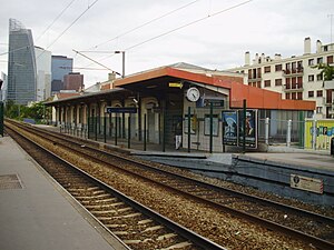
La Garenne-Colombes station
Railway station in La Garenne-Colombes, France
Distance: Approx. 695 meters
Latitude and longitude: 48.90943407,2.2399216
La Garenne-Colombes station is a French railway station serving the commune of La Garenne-Colombes on the Paris–Saint-Germain-en-Laye railway. It is largely located on the territory of the commune of Colombes, on the edge of the commune of La Garenne-Colombes, from where the main entrance to the station is located on Rue de l'Arrivée. This station is served by trains from the Line L of the Transilien commuter rail network.
Weather in this IP's area
overcast clouds
16 Celsius
16 Celsius
15 Celsius
17 Celsius
1026 hPa
75 %
1026 hPa
1021 hPa
10000 meters
5.14 m/s
20 degree
100 %
07:29:25
20:02:19