Country:
 France
Region:
City:
Latitude and Longitude:
Time Zone:
Postal Code:
IP information under different IP Channel
ip-api
Country
Region
City
ASN
Time Zone
ISP
Blacklist
Proxy
Latitude
Longitude
Postal
Route
IPinfo
Country
Region
City
ASN
Time Zone
ISP
Blacklist
Proxy
Latitude
Longitude
Postal
Route
MaxMind
Country
Region
City
ASN
Time Zone
ISP
Blacklist
Proxy
Latitude
Longitude
Postal
Route
Luminati
Country
FRRegion
pac
City
lagarde
ASN
Time Zone
Europe/Paris
ISP
Eurofiber France SAS
Latitude
Longitude
Postal
db-ip
Country
Region
City
ASN
Time Zone
ISP
Blacklist
Proxy
Latitude
Longitude
Postal
Route
ipdata
Country
Region
City
ASN
Time Zone
ISP
Blacklist
Proxy
Latitude
Longitude
Postal
Route
Popular places and events near this IP address

Arc de Triomphe
Triumphal arch in Paris, France
Distance: Approx. 352 meters
Latitude and longitude: 48.87377778,2.29502778
The Arc de Triomphe de l'Étoile, often called simply the Arc de Triomphe, is one of the most famous monuments in Paris, France, standing at the western end of the Champs-Élysées at the centre of Place Charles de Gaulle, formerly named Place de l'Étoile—the étoile or "star" of the juncture formed by its twelve radiating avenues. The location of the arc and the plaza is shared between three arrondissements, 16th (south and west), 17th (north), and 8th (east). The Arc de Triomphe honours those who fought and died for France in the French Revolutionary and Napoleonic Wars, with the names of all French victories and generals inscribed on its inner and outer surfaces.

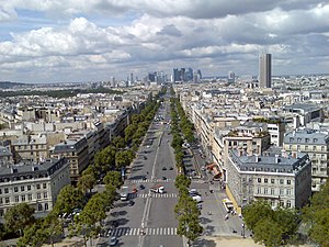
Place Charles de Gaulle
Public square in Paris, France
Distance: Approx. 329 meters
Latitude and longitude: 48.87388889,2.29472222
The Place Charles de Gaulle (French: [plas ʃaʁl də ɡol]), historically known as the Place de l'Étoile (French: [plas də letwal]), is a large road junction in Paris, France, the meeting point of twelve straight avenues (hence its historic name, which translates as "Square of the Star") including the Champs-Élysées. It was renamed in 1970, following the death of President Charles de Gaulle. It is still often referred to by its original name; the nearby Métro and RER station retains the designation Charles de Gaulle–Étoile.

Argentine station
Metro station in Paris, France
Distance: Approx. 192 meters
Latitude and longitude: 48.87527778,2.29
Argentine (French pronunciation: [aʁʒɑ̃tin] ) is a station on Line 1 of the Paris Métro, located on the boundary between the 16th arrondissement and the 17th arrondissement, in the western part of the city.

Charles de Gaulle–Étoile station
Metro and train station in Paris
Distance: Approx. 341 meters
Latitude and longitude: 48.87388889,2.295
Charles de Gaulle–Étoile station (French: [ʃaʁl də ɡol etwal] ) is a station on Line 1, Line 2 and Line 6 of the Paris Métro, as well as on Île-de-France's commuter rail RER A. It lies on the border of the 8th, 16th and 17th arrondissements of Paris. Originally called simply Étoile, after its location at Place de l'Étoile, it took on the additional name of President Charles de Gaulle in 1970.

Avenue des Ternes
Distance: Approx. 324 meters
Latitude and longitude: 48.87916667,2.29138889
The Avenue des Ternes is an avenue in the 17th arrondissement of Paris, between the Place des Ternes and the Boulevard Gouvion-Saint-Cyr. It is 920 m (0.57 mi) long and 35 m (115 ft) wide and was given its present name in 1863. It is on both sides of the Place Tristan-Bernard.
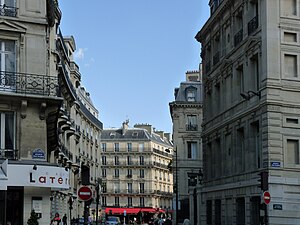
Rue de Tilsitt
Street in Paris, France
Distance: Approx. 258 meters
Latitude and longitude: 48.87527778,2.29527778
The Rue de Tilsitt is a street in the 8th and 17th arrondissements of Paris. It is one of two streets which form a circle around the Place de l’Étoile (renamed the Place Charles de Gaulle in 1970) - the other is the Rue de Presbourg. It was named after the Peace of Tilsit by a decree of 2 March 1864 (its spelling with the two final "t"s reflects old German spellings, which tended to double terminal consonants after short vowels).
Avenue de la Grande Armée
Major thoroughfare in Paris
Distance: Approx. 262 meters
Latitude and longitude: 48.87583333,2.28861111
The Avenue de la Grande Armée is an avenue in Paris, France, marking the boundary between its 16th and 17th arrondissements. It was formerly named Avenue de la Porte Maillot as part of Route nationale 13, but was renamed to its present name in 1864 in honour of the Grande Armée of the Napoleonic Wars.

Embassy of Ireland, Paris
Diplomatic mission of Ireland to France
Distance: Approx. 252 meters
Latitude and longitude: 48.8740752,2.2914557
The Embassy of Ireland in Paris (French: Ambassade d'Irlande à Paris) is the diplomatic mission of Ireland to France. It is located at 12 Avenue Foch in the 16th arrondissement. Ireland is also represented in France by honorary consuls in Cherbourg, Antibes/Cannes,Toulouse and Lyon.

Hôtel de Breteuil
Hôtel particulier in Paris, France
Distance: Approx. 260 meters
Latitude and longitude: 48.874,2.2915
The Hôtel de Breteuil is a historic building in the 16th arrondissement of Paris, France.

Salle Wagram
Distance: Approx. 353 meters
Latitude and longitude: 48.8767,2.2969
The Salle Wagram is a historic auditorium in the 17th arrondissement of Paris, France. It was built in 1865. It has been listed as an official historical monument by the French Ministry of Culture since March 2, 1981.
L'Arc de Triomphe, Wrapped
2021 artwork and event
Distance: Approx. 350 meters
Latitude and longitude: 48.87379722,2.29501111
L'Arc de Triomphe, Wrapped, known as "L'Arc de Triomphe Empaqueté" in French, was a temporary art installation by artists Christo and Jeanne-Claude where the Arc de Triomphe in Paris was wrapped in a silver-blue fabric and red rope for two weeks in 2021.
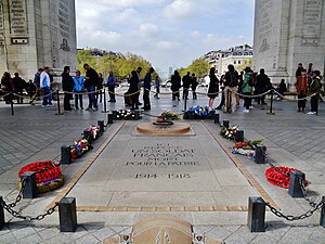
Tomb of the Unknown Soldier (France)
War memorial
Distance: Approx. 352 meters
Latitude and longitude: 48.87377778,2.29502778
The Tomb of the Unknown Soldier (French: Tombe du Soldat inconnu) holds an unidentified member of the French armed forces killed during the First World War, to symbolically commemorate all soldiers who have died for France throughout history. It was installed in Paris under the Arc de Triomphe on 11 November 1920, simultaneously with the interment of a British unknown soldier in Westminster Abbey, making both graves the first examples of a tomb of the Unknown Soldier, and the first to honour the unknown dead of the First World War. The burial site, surrounded by black metal posts linked together by chains, consists of a slab of granite from Vire on which is inscribed the epitaph: Ici repose un soldat français mort pour la Patrie, 1914–1918 ("Here rests a French soldier who died for the Fatherland, 1914–1918").
Weather in this IP's area
overcast clouds
16 Celsius
16 Celsius
15 Celsius
17 Celsius
1026 hPa
76 %
1026 hPa
1018 hPa
10000 meters
5.14 m/s
20 degree
100 %
07:29:16
20:02:07