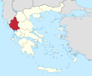
Country:
 Greece
Region:
City:
Latitude and Longitude:
Time Zone:
Postal Code:
IP information under different IP Channel
ip-api
Country
Region
City
ASN
Time Zone
ISP
Blacklist
Proxy
Latitude
Longitude
Postal
Route
IPinfo
Country
Region
City
ASN
Time Zone
ISP
Blacklist
Proxy
Latitude
Longitude
Postal
Route
MaxMind
Country
Region
City
ASN
Time Zone
ISP
Blacklist
Proxy
Latitude
Longitude
Postal
Route
Luminati
Country
GRASN
Time Zone
Europe/Athens
ISP
University Of Ioannina
Latitude
Longitude
Postal
db-ip
Country
Region
City
ASN
Time Zone
ISP
Blacklist
Proxy
Latitude
Longitude
Postal
Route
ipdata
Country
Region
City
ASN
Time Zone
ISP
Blacklist
Proxy
Latitude
Longitude
Postal
Route
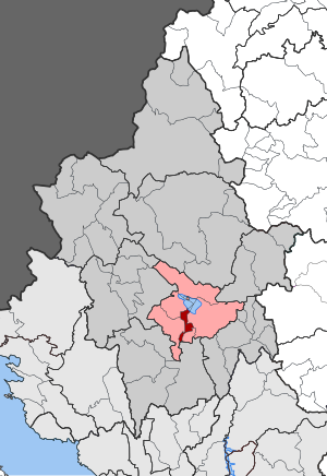
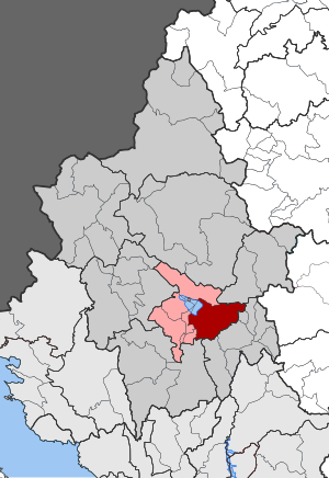
Popular places and events near this IP address

Ioannina
Capital and largest city of Ioannina and Epirus, Greece
Distance: Approx. 5453 meters
Latitude and longitude: 39.66361111,20.85222222
Ioannina (Greek: Ιωάννινα Ioánnina [i.oˈa.ni.na] ), often called Yannena (Γιάννενα Yánnena [ˈʝa.ne.na]) within Greece, is the capital and largest city of the Ioannina regional unit and of Epirus, an administrative region in northwestern Greece. According to the 2021 census, the city population was 64,896 while the municipality had 113,978 inhabitants. It lies at an elevation of approximately 500 metres (1,640 feet) above sea level, on the western shore of Lake Pamvotis (Παμβώτις).
Epirus (region)
Administrative region of Greece
Distance: Approx. 4158 meters
Latitude and longitude: 39.6,20.8
Epirus ( ih-PY-rəs; Greek: Ήπειρος, romanized: Ípiros, [ˈi.pi.ros]) is a traditional geographic and modern administrative region in northwestern Greece. It borders the regions of Western Macedonia and Thessaly to the east, West Greece to the south, the Ionian Sea and Ionian Islands to the west and Albania to the north. The region has an area of about 9,200 km2 (3,600 sq mi).
Anatoli
Municipal unit in Greece
Distance: Approx. 2795 meters
Latitude and longitude: 39.63333333,20.86666667
Anatoli (Greek: Ανατολή, romanized: Anatolí) is a town and a former municipality in the Ioannina regional unit, Epirus, Greece. Since the 2011 local government reform it is part of the municipality Ioannina, of which it is a municipal unit. The municipal unit has an area of 15.845 km2, the community 7.698 km2.
Pamvotida
Municipal unit in Greece
Distance: Approx. 4772 meters
Latitude and longitude: 39.61666667,20.9
Pamvotida (Greek: Παμβώτιδα) is a former municipality in the Ioannina regional unit, Epirus, Greece. Since the 2011 local government reform it is part of the municipality Ioannina, of which it is a municipal unit. It is named after the Lake of Ioannina, which is also known as Pamvotida.
University of Ioannina
Distance: Approx. 414 meters
Latitude and longitude: 39.6175,20.84083333
The University of Ioannina (UoI; Greek: Πανεπιστήμιο Ιωαννίνων, Panepistimio Ioanninon) is a public university located in Ioannina, Greece. The university was founded in 1964, as a charter of the Aristotle University of Thessaloniki and became an independent university in 1970. As of 2017, there is a student population of 25,000 enrolled at the university (21,900 at the undergraduate level and 3,200 at the postgraduate level) and 580 faculty members, while teaching is further supplemented by 171 Teaching Fellows and 132 Technical Laboratory staff.
Katsikas
Community in Greece
Distance: Approx. 3344 meters
Latitude and longitude: 39.61666667,20.88333333
Katsikas (Greek: Κατσικάς) is the largest village of the municipal unit Pamvotida, in the Ioannina regional unit, Epirus, northern Greece. Since the 2011 local government reform it is part of the municipality Ioannina. Its population is 5,180 (2021).
Sanjak of Ioannina
Sanjak of the Ottoman Empire
Distance: Approx. 5032 meters
Latitude and longitude: 39.66,20.85
The Sanjak of Ioannina (variously also Janina or Yanina, Ottoman Turkish: Sanjak-i Yanya) was a sanjak (second-level province) of the Ottoman Empire whose capital was Ioannina in Epirus.

Greek National Road 17
Trunk road in Greece
Distance: Approx. 4278 meters
Latitude and longitude: 39.5833,20.8162
Greek National Road 17 (Greek: Εθνική Οδός 17, abbreviated as EO17) is a single carriageway road in northwestern Greece. It connects Ioannina with Dodoni, via Bizani.
Panepirotan National Athletic Center
Distance: Approx. 1833 meters
Latitude and longitude: 39.62222222,20.86361111
The Panepirotiko Stadio of Ioannina (Greek: Πανηπειρωτικό Στάδιο Ιωαννίνων), more commonly known as Panepirotiko Stadio (Greek: "Πανηπειρωτικό Στάδιο") is a sports venue in Ioannina, Epirus, Greece. Panepirotiko Stadio is part of the Panepirotiko Sports Center of the East, 50 games are held every year in various sports, it is open for use to the public and in amateur clubs as well as in sports activities and school championships.

Veli Pasha Mosque (Ioannina)
Historical mosque in Ioannina, Greece
Distance: Approx. 5552 meters
Latitude and longitude: 39.66416667,20.85527778
The Veli Pasha Mosque (Greek: Τζαμί του Βελή Πασά, from Turkish: Veli Paşa Camii) is an Ottoman building located in the Greek town of Ioannina, in the northwest region of Epirus. The mosque was renovated at the turn of the 19th century by Veli Pasha of Ioannina and formed a complex consisting in particular of a madrasa and kitchens. Today it is no longer open for worship.
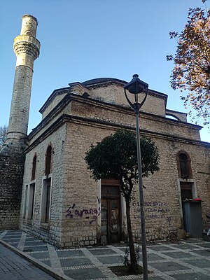
Kaloutsiani Mosque
Historical mosque in Ioannina, Greece
Distance: Approx. 5174 meters
Latitude and longitude: 39.66083333,20.85444444
The Mosque of Kaloutsiani (Turkish: Kanlı Çeşme Camii, lit. 'mosque of the bloody fountain', rendered in Greek as Τζαμί Καλούτσιανης) is a historical Ottoman mosque in the town of Ioannina, Epirus, in northwestern Greece. It was built in 1740, and since 2005 it been the subject of restoration campaigns and works. It is one of several surviving mosques in Ioannina, others being the Veli Pasha Mosque, the Fethiye Mosque and the Aslan Pasha Mosque.
Pedini, Greece
Community in Greece
Distance: Approx. 1686 meters
Latitude and longitude: 39.6,20.84166667
Pedini (Greek: Πεδινή, before 1928: Ραψίστα - Rapsista) is a village in the municipal unit of Bizani, Ioannina regional unit, Greece. In 2021 its population was 2,605. Between 1997 and 2010, it was the seat of the municipality Bizani.
Weather in this IP's area
few clouds
23 Celsius
23 Celsius
23 Celsius
23 Celsius
1015 hPa
73 %
1015 hPa
960 hPa
10000 meters
1.03 m/s
140 degree
20 %
07:11:36
19:57:13