Country:
Region:
City:
Latitude and Longitude:
Time Zone:
Postal Code:
IP information under different IP Channel
ip-api
Country
Region
City
ASN
Time Zone
ISP
Blacklist
Proxy
Latitude
Longitude
Postal
Route
Luminati
Country
ASN
Time Zone
Europe/Amsterdam
ISP
EveryWare AG
Latitude
Longitude
Postal
IPinfo
Country
Region
City
ASN
Time Zone
ISP
Blacklist
Proxy
Latitude
Longitude
Postal
Route
db-ip
Country
Region
City
ASN
Time Zone
ISP
Blacklist
Proxy
Latitude
Longitude
Postal
Route
ipdata
Country
Region
City
ASN
Time Zone
ISP
Blacklist
Proxy
Latitude
Longitude
Postal
Route
Popular places and events near this IP address

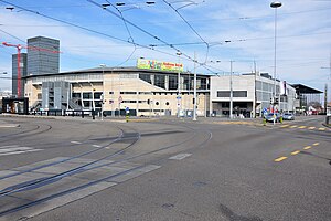
Hallenstadion
Stadium in Zurich, Switzerland
Distance: Approx. 902 meters
Latitude and longitude: 47.41138889,8.55166667
The Hallenstadion (German: Zürcher Hallenstadion, Zürich Indoor Stadium) is a multi-purpose facility in the Oerlikon quarter of northern Zürich. It has a capacity of 11,200 spectators. Designed by Bruno Giacometti, it opened on November 4, 1939, and was renovated in 2004–05.

Oerlikon (Zürich)
Quarter of Zürich, Switzerland
Distance: Approx. 310 meters
Latitude and longitude: 47.41666667,8.55
Oerlikon is a quarter in the northern part of the city of Zürich, Switzerland. A formerly independent municipality, Oerlikon was merged with Zürich in 1934 and forms today, together with Affoltern and Seebach, the city district 11.
Kalaidos University of Applied Sciences
University in Switzerland
Distance: Approx. 520 meters
Latitude and longitude: 47.415367,8.543868
The Kalaidos University of Applied Sciences Switzerland (Kalaidos UAS) is a University of Applied Sciences in Switzerland with the departments of Business and Management, Law, Health, Music and Applied Psychology. It was founded in 1997 and today is one of nine accredited Swiss Universities of Applied Sciences, being the only privately owned one. It has 3’813 students, 766 lecturers (as of December 31, 2023) and around 12’000 graduates.

Maschinenfabrik Oerlikon
Swiss engineering company (1876-1967)
Distance: Approx. 905 meters
Latitude and longitude: 47.4125,8.541
Maschinenfabrik Oerlikon was a Swiss engineering company based in the Zürich district of Oerlikon known for the early development of electric locomotives. It was founded in 1876 as the Werkzeug- und Maschinen-Fabrik Oerlikon by the industrialist Peter Emil Huber-Werdmüller, and occupied a large site immediately to the west of Oerlikon railway station. In 1906, the armaments business was demerged to form Schweizerische Werkzeugmaschinenfabrik Oerlikon, which evolved into the technology company OC Oerlikon and the armaments company Rheinmetall Air Defence (formerly Oerlikon Contraves).

Zürich Oerlikon railway station
Railway station in Zürich, Switzerland
Distance: Approx. 896 meters
Latitude and longitude: 47.4115,8.54411111
Zürich Oerlikon railway station (German: Bahnhof Zürich Oerlikon) is a railway station located in District 11 of Zürich. It is one of the two major nodes for local and regional public transportation in the northern part of Zürich, the other being the railway station at Zurich Airport. Oerlikon station is a junction station, or Keilbahnhof: tracks 1 and 2 are on the Zürich–Winterthur line, while tracks 3–8 are on the Oerlikon–Bülach line.

Oerliker Park
Distance: Approx. 894 meters
Latitude and longitude: 47.41472222,8.53805556
The Oerliker Park is a public multi-purpose district park covering 188,000 square feet (17,500 m2) in Oerlikon, just to the north of Zürich. The Oerliker Park was created by the Grün Stadt Zürich in 2001 as part of the regional development project "Zentrum Zürich Nord" and was the first of four parks. The MFO-Park (2002), the Louis-Häfliger-Park (2003) and the Wahlenpark (2005) were built close-by, each of which are matched to local needs as district- and neighbourhood-parks, as well as playgrounds.
MFO-Park
Distance: Approx. 962 meters
Latitude and longitude: 47.41222222,8.54027778
The MFO-Park is a public park in the Oerlikon quarter of the Swiss city of Zürich. The area to the north of Zürich Oerlikon railway station was once home to the extensive works of Maschinenfabrik Oerlikon (MFO), as site that has now been redeveloped as Neu Oerlikon. As part of that redevelopment, four new parks were created, including the MFO-Park, which was created on the footprint of one of MFO's buildings.
Wahlenpark
Public park in New Oerlikon in Zurich
Distance: Approx. 634 meters
Latitude and longitude: 47.41583333,8.54111111
The Wahlenpark is a public park in New Oerlikon in the northern part of Zurich. The park covers 139,931 ft². It was created in 2005 as part of the regional development "Zentrum Zürich Nord", as the last of four parks.
Leutschenpark
Public park in the northern Zürich neighbourhood of Leutschenbach
Distance: Approx. 662 meters
Latitude and longitude: 47.41805556,8.55666667
Leutschenpark is a public park in the northern Zürich neighbourhood of Leutschenbach. As the main park, the 161,459 ft² Leutschenpark and its flowing shapes bring a new accent to the district which was previously characterized by industry and service buildings. The former industrial and commercial district to the north of Zürich is being transformed into an attractive, mixed neighbourhood for living and working.

Zurich Seebach railway station
Railway station in the Seebach quarter of the Swiss city of Zürich
Distance: Approx. 307 meters
Latitude and longitude: 47.4186,8.544
Zürich Seebach (German: Zürich Seebach) is a railway station in the Seebach quarter of the Swiss city of Zürich. It is located on the Wettingen–Effretikon railway line (Furttal line).
Sevanan Business School
Distance: Approx. 824 meters
Latitude and longitude: 47.4179,8.5588
Sevanan Business School was a Swiss private business school. It offered management courses at undergraduate level and Masters level, accredited to London School of Marketing. Sevanan Business School provided international programs in business management & marketing management.

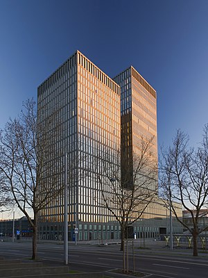
Sunrise Tower (Zurich)
Skyscraper in Zürich, Switzerland
Distance: Approx. 690 meters
Latitude and longitude: 47.41376,8.55265
The Sunrise Tower (German: Sonnenaufgangsturm) also known as Hochhaus Hagenholzstrasse is a high-rise office building in Zürich, Switzerland. Built between 2000 and 2004, the composition consists of two cojoined towers standing at 90 m (300 ft) respectively 72.5 m (238 ft), with the taller half being divided into 26 floors. They share the position of the 15th tallest buildings in Switzerland.
Weather in this IP's area
overcast clouds
8 Celsius
7 Celsius
7 Celsius
9 Celsius
1030 hPa
86 %
1030 hPa
976 hPa
10000 meters
2.06 m/s
20 degree
100 %
07:20:21
16:58:51


