Country:
Region:
City:
Latitude and Longitude:
Time Zone:
Postal Code:
IP information under different IP Channel
ip-api
Country
Region
City
ASN
Time Zone
ISP
Blacklist
Proxy
Latitude
Longitude
Postal
Route
Luminati
Country
Region
32
City
kriukivshchyna
ASN
Time Zone
Europe/Kyiv
ISP
Maximum-Net LLC
Latitude
Longitude
Postal
IPinfo
Country
Region
City
ASN
Time Zone
ISP
Blacklist
Proxy
Latitude
Longitude
Postal
Route
db-ip
Country
Region
City
ASN
Time Zone
ISP
Blacklist
Proxy
Latitude
Longitude
Postal
Route
ipdata
Country
Region
City
ASN
Time Zone
ISP
Blacklist
Proxy
Latitude
Longitude
Postal
Route
Popular places and events near this IP address

Zhuliany
Neighbourhood in the capital of Ukraine
Distance: Approx. 5406 meters
Latitude and longitude: 50.39338056,30.44044722
Zhuliany (Ukrainian: Жуляни) is a neighbourhood in the south-west of Kyiv, the capital of Ukraine. It is a predominantly cottage-built area, part of the Solomianskyi district. As well as Troieshchyna, Zhuliany became a part of Kyiv municipality in 1988.

Borshchahivka
Neighborhood located to the west and south-west of Kyiv
Distance: Approx. 6186 meters
Latitude and longitude: 50.426268,30.373728
Borshchahivka (Ukrainian: Борщагівка, Russian: Борщаговка) is a neighborhood located to the west and south-west of Kyiv, the capital of Ukraine. It is part of the city's Sviatoshynskyi District. The neighborhood is named after a large village that was founded at the site.
Vyshneve, Kyiv Oblast
City in Kyiv Oblast, Ukraine
Distance: Approx. 2100 meters
Latitude and longitude: 50.38694444,30.35805556
Vyshneve (Ukrainian: Вишневе) is a city in Bucha Raion, Kyiv Oblast, Ukraine, located two kilometres (1.2 mi) south of the capital Kyiv. Vyshneve hosts the administration of Vyshneve urban hromada, one of the hromadas of Ukraine. It has a population of 42,983 (2022 estimate).

Kyiv Ukraine Temple
Latter-day Saint religious building in Ukraine
Distance: Approx. 4047 meters
Latitude and longitude: 50.404178,30.395324
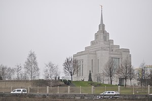
The Kyiv Ukraine Temple is the 134th operating temple of the Church of Jesus Christ of Latter-day Saints (LDS Church). The intent to build the temple was announced by the church's First Presidency on July 20, 1998. Located in Sofiivska Borshchahivka, near Kyiv (the capital of Ukraine), it is the LDS Church's 11th temple in Europe, the first in the territory of the former Soviet Union, and the second in the former Eastern Bloc.
Hatne, Ukraine
Rural locality in Kyiv Oblast, Ukraine
Distance: Approx. 2291 meters
Latitude and longitude: 50.35833333,30.39888889
Hatne (Ukrainian: Гатне) is a selo in Fastiv Raion in Kyiv Oblast of northern Ukraine. It hosts the administration of Hatne rural hromada, one of the hromadas of Ukraine.
Academy of Technological Sciences of Ukraine
Distance: Approx. 4981 meters
Latitude and longitude: 50.3623,30.442
The Academy of Technological Sciences of Ukraine (ATS of Ukraine, ATSU) is a Ukrainian national academy, a public organization aiming at the consolidation of the intellectual and industrial-technological potential of applied scientists, technologists, and other experts in Ukraine.

Chabany
Rural locality in Kyiv Oblast, Ukraine
Distance: Approx. 4891 meters
Latitude and longitude: 50.34027778,30.42277778
Chabany (Ukrainian: Чабани) is a rural settlement in Fastiv Raion of Kyiv Oblast (province), located on the southern border of Kyiv. It hosts the administration of Chabany settlement hromada, one of the hromadas of Ukraine. Population: 5,334 (2022 estimate).
Teremky (Kyiv Metro)
Kyiv Metro Station
Distance: Approx. 5773 meters
Latitude and longitude: 50.36704444,30.45420278
Teremky (Ukrainian: Теремки, ) is a station on the Kyiv Metro's Obolonsko–Teremkivska Line opened on 6 November 2013. It is the southern end of the line, located just after the Ipodrom station. The station is named after the Teremky neighborhood of Kyiv.

Kiltseva Doroha (Kyiv Light Rail)
Kyiv Light Rail station
Distance: Approx. 6090 meters
Latitude and longitude: 50.42527778,30.36722222
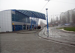
Kiltseva Doroha (Ukrainian: Кільцева дорога) is a station on the Kyiv Light Rail. It was opened in 1977.

Teremky
Neighborhood of Kyiv in Holosiivskyi District, Ukraine
Distance: Approx. 5771 meters
Latitude and longitude: 50.36694444,30.45416667
Teremky (Ukrainian: Теремки) is a neighborhood located in the Holosiivskyi district of Kyiv, the capital of Ukraine. It is located in the southern part of the city, in between the city's Holosiiv, Feofaniia, and Zhuliany neighborhoods. The National Expocenter of Ukraine and Kyiv's Ipodrom horse racetrack are located in the neighborhood.
Kriukivshchyna
Rural locality in Kyiv Oblast, Ukraine
Distance: Approx. 445 meters
Latitude and longitude: 50.36833333,30.36805556
Kriukivshchyna (Ukrainian: Крюківщина) is a village in Bucha Raion (district) of Kyiv Oblast in northern Ukraine. It belongs to Vyshneve urban hromada, one of the hromadas of Ukraine.

Odesa Square
Street in Kyiv, Ukraine
Distance: Approx. 6072 meters
Latitude and longitude: 50.37,30.45861111
Odesa Square (or Odeska Square; Ukrainian: Одеська площа, romanized: Odeska ploshcha, pronounced [ɔˈdɛsʲkɐ ˈpɫɔʃt͡ʃɐ]) is one of the squares of Kyiv, Ukraine. It is located in the neighborhood Teremky in the Holosiiv Raion of Kyiv. It was named after big Ukrainian city port Odesa.
Weather in this IP's area
few clouds
6 Celsius
2 Celsius
6 Celsius
8 Celsius
1010 hPa
81 %
1010 hPa
988 hPa
10000 meters
4.65 m/s
8.74 m/s
260 degree
13 %
07:17:55
16:09:50

