Country:
 Czech Republic
Region:
City:
Latitude and Longitude:
Time Zone:
Postal Code:
IP information under different IP Channel
ip-api
Country
Region
City
ASN
Time Zone
ISP
Blacklist
Proxy
Latitude
Longitude
Postal
Route
IPinfo
Country
Region
City
ASN
Time Zone
ISP
Blacklist
Proxy
Latitude
Longitude
Postal
Route
MaxMind
Country
Region
City
ASN
Time Zone
ISP
Blacklist
Proxy
Latitude
Longitude
Postal
Route
Luminati
Country
CZRegion
10
City
prague
ASN
Time Zone
Europe/Prague
ISP
Quantcom, a.s.
Latitude
Longitude
Postal
db-ip
Country
Region
City
ASN
Time Zone
ISP
Blacklist
Proxy
Latitude
Longitude
Postal
Route
ipdata
Country
Region
City
ASN
Time Zone
ISP
Blacklist
Proxy
Latitude
Longitude
Postal
Route
Popular places and events near this IP address

Žižkov Television Tower
TV tower in Prague, Czech Republic
Distance: Approx. 583 meters
Latitude and longitude: 50.08083333,14.45138889
The Žižkov Television Tower (Czech: Žižkovský vysílač) is a transmitter tower built in Prague between 1985 and 1992. Designed by the architect Václav Aulický and the structural engineer Jiří Kozák, it stands high above the city's traditional skyline from its position on top of a hill in the district of Žižkov, from which it takes its name. The tower is an example of high-tech architecture.

Vinohrady
Distance: Approx. 160 meters
Latitude and longitude: 50.07555556,14.44583333
Vinohrady (until 1960 Královské Vinohrady, in English literally "Royal Vineyards" German: Königliche Weinberge) is a cadastral district in Prague. It is so named because the area was once covered in vineyards dating from the 14th century. Vinohrady lies in the municipal and administrative districts of Prague 2 (west part), Prague 3 (north-east part) and Prague 10 (south-east part), little parts also of Prague 1 (Prague State Opera and Federal Assembly of Czechoslovakia) and Prague 4 (near Nusle).

Prague 2
Municipal district in Prague, Czechia
Distance: Approx. 425 meters
Latitude and longitude: 50.07416667,14.44277778
Prague 2, formally the Prague 2 Municipal District (Městská čast Praha 2), is a second-tier municipality in Prague. It is co-extensive with the national administrative district (správní obvod) of the same name. As of the end of 2004, 48,918 people lived in 34,689 homes in the district.

Jiřího z Poděbrad (Prague Metro)
Prague metro station
Distance: Approx. 258 meters
Latitude and longitude: 50.07783028,14.450295
Jiřího z Poděbrad (Czech pronunciation: [ˈjɪr̝iːɦo ˈspoɟɛbrat]) is a Prague Metro station on Line A, located in Vinohrady, Prague 3. In January 2023 it closed for reconstruction.

University of Finance and Administration
Czech academic publisher
Distance: Approx. 667 meters
Latitude and longitude: 50.0711122,14.4530614
The University of Finance and Administration (Czech: Vysoká škola finanční a správní o.p.s., VŠFS) is a private business school in the Czech Republic. It was founded by the Bank Academy and Czech Coal Group in 1999 and was one of the first private business schools in the country. It has had full university status from the accreditation committee of the Czech government since 2009.

Prague City University
Distance: Approx. 629 meters
Latitude and longitude: 50.07855556,14.43996667
Prague City University is an English-language private university in the Vinohrady district of Prague, Czech Republic, founded in 2004. Formerly known as Prague College, the university adopted its current name in 2021. The university has two campuses, both located in the Prague 1 district.
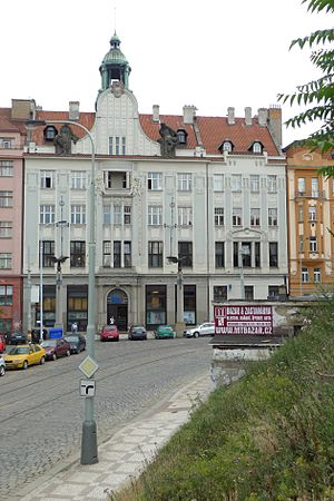
Vršovice Savings Bank Building
Bank in Prague, Czech Republic
Distance: Approx. 525 meters
Latitude and longitude: 50.071986,14.451495
Vršovice Savings Bank Building (Czech: Vršovická záložna or Vršovická spořitelna) is an Art Nouveau building, which is located in Prague 10-Vršovice. The architect of the building was Antonin Balšánek.
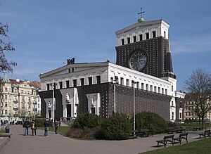
Church of the Most Sacred Heart of Our Lord
Distance: Approx. 289 meters
Latitude and longitude: 50.07803333,14.45060556
The Church of the Most Sacred Heart of Our Lord (Czech: Kostel Nejsvětějšího Srdce Páně) is a Roman Catholic church at Jiřího z Poděbrad Square in Prague's Vinohrady district. It was built between 1929 and 1932 and designed by the Slovene architect Jože Plečnik. Plečnik found the inspiration for this construction in old Christian and ancient patterns.

Šaloun Villa
Distance: Approx. 408 meters
Latitude and longitude: 50.0725,14.449
Šaloun Villa (Czech: Šalounova vila) is a studio in Prague designed by and for the sculptor Ladislav Šaloun. The villa was designed and built to construct the Jan Hus Memorial but it was also a meeting place for the Czech intelligentsia. Today the building has been restored and it is used for education.

Hus Congregational House
Church in Prague , Czech Republic
Distance: Approx. 208 meters
Latitude and longitude: 50.074343,14.4489
The Hus Congregational House, or Husův sbor, is a Hussite church in Dykova Street in Prague 10. It was completed in 1935 as part of a multi-functional development by architect Pavel Janák in the constructivist style. The tall, six-storey minimalist tower and belfry carries a 700 kg copper chalice as a symbol of the Hussite Church.

Vinohrady Water Tower
Water Tower in Prague, Czech Republic
Distance: Approx. 132 meters
Latitude and longitude: 50.0752,14.4491
Vinohrady Water Tower (Czech: Vinohradská vodárna) is a building in Vinohrady in Prague 10 which was originally built as a water tower. Today its architecture is recognized as culturally important although it is now converted to accommodate offices and apartments. The viewing platform at the top is 40 metres above the street level.

Jiřího z Poděbrad Square
Distance: Approx. 272 meters
Latitude and longitude: 50.078,14.4503
Jiřího z Poděbrad Square (George of Poděbrady Square, Czech: náměstí Jiřího z Poděbrad) is located in the Vinohrady district of Prague, the capital of the Czech Republic. It is dominated by the 1932 Art Nouveau Church of the Most Sacred Heart of Our Lord in its centre. The square is largely an urban park.
Weather in this IP's area
clear sky
19 Celsius
19 Celsius
18 Celsius
21 Celsius
1012 hPa
75 %
1012 hPa
981 hPa
10000 meters
4.12 m/s
80 degree
06:28:06
19:31:53