195.12.42.60 - IP Lookup: Free IP Address Lookup, Postal Code Lookup, IP Location Lookup, IP ASN, Public IP
Country:
Region:
City:
Location:
Time Zone:
Postal Code:
ISP:
ASN:
language:
User-Agent:
Proxy IP:
Blacklist:
IP information under different IP Channel
ip-api
Country
Region
City
ASN
Time Zone
ISP
Blacklist
Proxy
Latitude
Longitude
Postal
Route
db-ip
Country
Region
City
ASN
Time Zone
ISP
Blacklist
Proxy
Latitude
Longitude
Postal
Route
IPinfo
Country
Region
City
ASN
Time Zone
ISP
Blacklist
Proxy
Latitude
Longitude
Postal
Route
IP2Location
195.12.42.60Country
Region
obwalden
City
engelberg
Time Zone
Europe/Zurich
ISP
Language
User-Agent
Latitude
Longitude
Postal
ipdata
Country
Region
City
ASN
Time Zone
ISP
Blacklist
Proxy
Latitude
Longitude
Postal
Route
Popular places and events near this IP address

Engelberg
Municipality in Obwalden, Switzerland
Distance: Approx. 584 meters
Latitude and longitude: 46.82102778,8.40897222
Engelberg (lit.: mountain of angel(s)) is a village resort and a municipality in the canton of Obwalden in Switzerland. Alongside the central village of Engelberg, the municipality encompasses additional settlements, including Grafenort, Oberberg and Schwand. The municipality of Engelberg is an exclave, entirely encircled by the neighboring cantons of Bern, Nidwalden and Uri.

Engelberg Abbey
Benedictine monastery in Engelberg, Canton of Obwalden, Switzerland
Distance: Approx. 644 meters
Latitude and longitude: 46.82055556,8.40972222
Engelberg Abbey (German: Kloster Engelberg) is a Benedictine monastery in Engelberg, Canton of Obwalden, Switzerland. It was formerly in the Diocese of Constance, but is now in the Diocese of Chur. It is dedicated to Our Lady of the Angels and occupies a commanding position at the head of the Nidwalden Valley.

Trübsee
Lake in Wolfenschiessen, Central Switzerland, Switzerland
Distance: Approx. 3132 meters
Latitude and longitude: 46.79388889,8.39083333
Trübsee (1,788 m (5,866 ft)) is an intermediate cable car station by the Titlis Bergbahnen, Trüebsee (lit.: turbid lake, Germanized: Trübsee) is an Alpine lake (1,764 m (5,787 ft)) on the Ober Trüebsee Alpine pasture (or often just incorrectly shortened to Trüebsee) in the upper part of the extensive municipality of Wolfenschiessen in the Swiss canton of Nidwalden. The lake lies at the foot of the Titlis above the village resort of Engelberg. It can be reached from the village by cable car, or via several alpine walking paths, e.g.

Gross-Titlis-Schanze
Ski jump in Engelberg, Switzerland
Distance: Approx. 648 meters
Latitude and longitude: 46.81555556,8.40388889
Gross-Titlis-Schanze (en: Large Titlis hill) is a large ski jumping hill, located in Engelberg, Switzerland. It is named after the local mountain of Titlis, at an altitude of 1180 m above sea level and is a regular venue in the FIS Ski jumping World Cup. Mostly, the competitions take place in December, just before the Four Hills Tournament.

Rigidalstock
Mountain in Switzerland
Distance: Approx. 3735 meters
Latitude and longitude: 46.85222222,8.41963889
The Rigidalstock is a mountain of the Urner Alps, located on the border between the cantons of Nidwalden and Obwalden in Central Switzerland. It lies south of the Gross Walenstock. The closest locality is Engelberg on its southern side.
Hahnen
Mountain in Switzerland
Distance: Approx. 4149 meters
Latitude and longitude: 46.82388889,8.45561111
The Hahnen is a mountain of the Urner Alps, overlooking Engelberg in the Swiss canton of Obwalden. It has an elevation of 2,606 metres above sea level.

Eugenisee
Lake in Obwalden, Switzerland
Distance: Approx. 892 meters
Latitude and longitude: 46.819,8.39
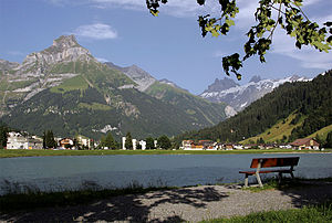
Eugenisee is a lake at Engelberg in the canton of Obwalden, Switzerland. In summer, it is stocked with brown trout and rainbow trout for fishing. In the floods of August 2005, the lake was filled with large quantities of sediments.

Grafenort – Engelberg Tunnel
Railway tunnel in Switzerland
Distance: Approx. 2169 meters
Latitude and longitude: 46.8374,8.3857
The Grafenort – Engelberg Tunnel is a railway tunnel on the Luzern–Stans–Engelberg-Bahn line, which forms one portion of the Zentralbahn in Switzerland. It replaced the steepest section of the line, an inclined length of 1,600 meters that had a peak gradient of 25%, allowing for a faster transit since its completion. Following a number of preparatory surveys and assessments, construction of the tunnel commenced during March 2000.

Engelberg railway station
Railway station in Switzerland
Distance: Approx. 203 meters
Latitude and longitude: 46.81952306,8.40263306
Engelberg railway station is a Swiss railway station in the municipality of Engelberg in the canton of Obwalden. It is the terminus of the Luzern–Stans–Engelberg line, which is owned by the Zentralbahn railway company.

Härzlisee
Artificial lake in Obwalden, Switzerland
Distance: Approx. 2379 meters
Latitude and longitude: 46.84138889,8.41111111
The Härzlisee is an artificial lake in Obwalden, Switzerland. It was created to serve the tourist area of Brunni.

Brunni (Engelberg)
Ski resort in Obwalden, Switzerland
Distance: Approx. 2354 meters
Latitude and longitude: 46.841172,8.411032
Brunni is a recreational area in the municipality of Engelberg, Obwalden, Switzerland. Located on a south-facing slope, it is known as "Engelberg's sunny side".

Gerschnialpbahn
Funicular railway in Switzerland
Distance: Approx. 917 meters
Latitude and longitude: 46.8145,8.3941
Gerschnialpbahn is a funicular railway in Obwalden, Switzerland. The line leads from Engelberg at 1000 m to Gerschnialp at 1262 m on the slopes of Titlis (3239 m). The funicular with two cars has a single track with a passing loop and a tunnel (88 m) at upper end.
Weather in this IP's area
few clouds
-1 Celsius
-6 Celsius
-1 Celsius
-1 Celsius
1023 hPa
80 %
1023 hPa
831 hPa
10000 meters
5.25 m/s
4.96 m/s
165 degree
24 %
