Country:
 Sweden
Region:
City:
Latitude and Longitude:
Time Zone:
Postal Code:
IP information under different IP Channel
ip-api
Country
Region
City
ASN
Time Zone
ISP
Blacklist
Proxy
Latitude
Longitude
Postal
Route
IPinfo
Country
Region
City
ASN
Time Zone
ISP
Blacklist
Proxy
Latitude
Longitude
Postal
Route
MaxMind
Country
Region
City
ASN
Time Zone
ISP
Blacklist
Proxy
Latitude
Longitude
Postal
Route
Luminati
Country
 DE
DEASN
Time Zone
Europe/Berlin
ISP
Arelion Sweden AB
Latitude
Longitude
Postal
db-ip
Country
Region
City
ASN
Time Zone
ISP
Blacklist
Proxy
Latitude
Longitude
Postal
Route
ipdata
Country
Region
City
ASN
Time Zone
ISP
Blacklist
Proxy
Latitude
Longitude
Postal
Route
Popular places and events near this IP address

Råsunda Stadium
Association football stadium in Solna, Sweden between 1937–2012
Distance: Approx. 860 meters
Latitude and longitude: 59.36277778,17.99638889
Råsunda Stadium (Swedish: [ˈrôːˌsɵnːda] ; also known as Råsunda Fotbollsstadion, Råsundastadion, Råsunda Football Stadium or just Råsunda) was the Swedish national football stadium. It was located in Solna Municipality in Stockholm and named after the district in Solna where it is located. The stadium was demolished in 2013 after being replaced by the Friends Arena.

Råsunda (district)
Urban district in Solna Municipality, Sweden
Distance: Approx. 753 meters
Latitude and longitude: 59.36472222,17.99472222
Råsunda is a district in Solna Municipality, and a suburb in the Stockholm metropolitan area with around 17,500 inhabitants. The movie industry set up in the area Filmstaden, formerly an ostrich farm, in 1919–1969 (nowadays the area has homes, offices) in western Råsunda. A large football stadium (Råsunda Stadium) stood in central Råsunda 1937–2003, on the grounds of a sports field that existed from 1910.

European Centre for Disease Prevention and Control
Agency of the European Union
Distance: Approx. 819 meters
Latitude and longitude: 59.37277778,18.01722222
The European Centre for Disease Prevention and Control (ECDC) is an agency of the European Union (EU) whose mission is to strengthen Europe's defences against infectious diseases. It covers a wide spectrum of activities, such as: surveillance, epidemic intelligence, response, scientific advice, microbiology, preparedness, public health training, international relations, health communication, and the scientific journal Eurosurveillance. The centre was established in 2004 and is headquartered in Solna, Sweden.

Hagalund
Distance: Approx. 889 meters
Latitude and longitude: 59.36220278,18.0117
Hagalund () is a residential area and railway yard in Solna Municipality, 5 km north of central Stockholm. It is known for the blue highrise buildings "Blåkulla" (Blue Hill or Blockula) which, against a rather strong and long-lasting opinion, in the beginning of the 1970s replaced a picturesque working-class and craftsman neighbourhood built in the 1890s and portrayed by artist Olle Olsson Hagalund. There are still about half a dozen old houses preserved, a minor area called Gamla Hagalund (Old Hagalund) in the eastern part of the area.

Solna centrum metro station
Stockholm Metro station
Distance: Approx. 1102 meters
Latitude and longitude: 59.35997222,17.998
Solna centrum is a metro station in Solna Municipality, approximately 5 km (3.1 mi) from central Stockholm, Sweden. It is close to the Sona Centrum shopping cenrre and Strawberry Arena. It opened on 31 August 1975 as part the first stretch of the Blue Line between T-Centralen and Hjulsta.

Strawberry Arena
Association football stadium in Solna, Stockholm, Sweden
Distance: Approx. 438 meters
Latitude and longitude: 59.3725,18
Nationalarenan, known as Strawberry Arena for sponsorship reasons, is a retractable roof multi-purpose stadium in Stockholm, Sweden. Located next to the lake Råstasjön in Solna, just north of the City Centre, it is the largest stadium in Scandinavia. Since its opening, the venue has served as Sweden's national stadium for men's football, hence the name Nationalarenan.

Råstasjön
Lake in Solna Municipality, Sweden
Distance: Approx. 943 meters
Latitude and longitude: 59.37222222,17.98888889
Råstasjön is a lake next to the Strawberry Arena in Solna north of Stockholm, Sweden. On the lake, the 1912 final of the Swedish national bandy championship took place. A promenade of 2.1 km length leads around the lake.

SAS Frösundavik Office Building
Building in Frösundavik, Solna, Sweden
Distance: Approx. 1132 meters
Latitude and longitude: 59.3717,18.0239
The SAS Frösundavik Office Building is an office building in Frösundavik, Solna Municipality, Sweden, north of Stockholm. It serves as the head office of Scandinavian Airlines (SAS) and the SAS Group. The SAS head office was for a brief period located in a different building on the property of Stockholm Arlanda Airport in Sigtuna Municipality.

Råsunda IP
Football stadium in Solna, Sweden
Distance: Approx. 865 meters
Latitude and longitude: 59.36274167,17.99630833
Råsunda IP (Swedish pronunciation: [ˈrôːˌsɵnːda] ) was a football stadium in Solna, Sweden and the former home stadium for the football team AIK between 1910 and 1912. It was founded in 1910 and was demolished in 1937 when Råsunda Stadium was built on the existing site of the stadium.
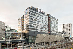
Westfield Mall of Scandinavia
Shopping mall in Stockholm, Sweden
Distance: Approx. 79 meters
Latitude and longitude: 59.37,18.00472222
Westfield Mall of Scandinavia is a shopping mall located in Solna in Stockholm, Sweden. It was inaugurated on November 12, 2015, and is the fourth largest mall in the Nordic countries with 224 stores and restaurants, many of them with double-height storefronts up to 8 m (26 ft) tall. 50,000 shoppers showed up to the opening of the mall.

Solna Gymnasium
Secondary school in Solna, Sweden
Distance: Approx. 297 meters
Latitude and longitude: 59.3677,18.0003
Solna Gymnasium is a secondary school in Solna, Sweden, in the Stockholm metropolitan area. It was opened as the Solna Läroverk in April 1948. Crown Prince Gustaf VI Adolf of Sweden attended the opening.

Solna station
Railway station in Solna, Sweden
Distance: Approx. 606 meters
Latitude and longitude: 59.36472222,18.01027778
Solna is a station in Solna Municipality in Stockholm for commuter trains and the Tvärbanan light rail. The lines J40 (Uppsala C-Södertälje C), J41 (Märsta-Södertälje C), J42 (Märsta-Nynäshamn) and L30 (Sickla-Solna station) stop here, as well as ten bus lines. The commuter train station opened in 1895, but was moved a 100 meters in 1903 and moved again in 1911, when the tunnel through the hill Hagalundsberget to the south was completed.
Weather in this IP's area
clear sky
10 Celsius
9 Celsius
9 Celsius
11 Celsius
1020 hPa
93 %
1020 hPa
1019 hPa
10000 meters
2.06 m/s
130 degree
07:33:32
17:32:18