Country:
 Latvia
Region:
City:
Latitude and Longitude:
Time Zone:
Postal Code:
IP information under different IP Channel
ip-api
Country
Region
City
ASN
Time Zone
ISP
Blacklist
Proxy
Latitude
Longitude
Postal
Route
IPinfo
Country
Region
City
ASN
Time Zone
ISP
Blacklist
Proxy
Latitude
Longitude
Postal
Route
MaxMind
Country
Region
City
ASN
Time Zone
ISP
Blacklist
Proxy
Latitude
Longitude
Postal
Route
Luminati
Country
LVASN
Time Zone
Europe/Riga
ISP
SIA Tet
Latitude
Longitude
Postal
db-ip
Country
Region
City
ASN
Time Zone
ISP
Blacklist
Proxy
Latitude
Longitude
Postal
Route
ipdata
Country
Region
City
ASN
Time Zone
ISP
Blacklist
Proxy
Latitude
Longitude
Postal
Route
Popular places and events near this IP address
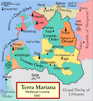
Archbishopric of Riga
Medieval Catholic state in present-day Latvia (1186-1561)
Distance: Approx. 1055 meters
Latitude and longitude: 56.96666667,24.13333333
The Archbishopric of Riga (Latin: Archiepiscopatus Rigensis, Low German: Erzbisdom Riga) was an archbishopric in Medieval Livonia, a subject to the Holy See. It was established in 1186 as the bishopric of Livonia at Ikšķile, then after moving to Riga it became the bishopric of Riga in 1202 and was elevated to an archbishopric in 1255.

Swedish Livonia
Baltic dominion of the Swedish Empire (1629–1721)
Distance: Approx. 1051 meters
Latitude and longitude: 56.9667,24.1333
Swedish Livonia (Swedish: Svenska Livland) was a dominion of the Swedish Empire from 1629 until 1721. The territory, which constituted the southern part of modern Estonia (including the island of Ösel ceded by Denmark after the Treaty of Brömsebro) and the northern part of modern Latvia (the Vidzeme region), represented the conquest of the major part of the Polish-Lithuanian Duchy of Livonia during the 1600–1629 Polish-Swedish War. Parts of Livonia and the city of Riga were under Swedish control as early as 1621 and the situation was formalized in the Truce of Altmark 1629, but the whole territory was not ceded formally until the Treaty of Oliva in 1660.
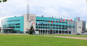
Arena Riga
Indoor arena in Riga, Latvia
Distance: Approx. 1047 meters
Latitude and longitude: 56.96795833,24.12134444
Arena Riga (Latvian: Arēna Rīga) is an indoor arena in Riga, Latvia. It is primarily used for ice hockey, basketball and concerts. Arena Riga holds a maximum of 14,500 and was opened on 15 February 2006.

BA School of Business and Finance
Business school in Riga, Latvia
Distance: Approx. 286 meters
Latitude and longitude: 56.97560278,24.13496389
BA School of Business and Finance (Latvian: Banku Augstskola) is one of the leading, self-financing business schools in Latvia. It was founded in 1992 as a Banking College under the Bank of Latvia and received accreditation in 1997 In 2007 BA School of Business and Finance celebrated its 15th anniversary. It supports United Nations initiative and follows the Principles for Responsible Management Education.

Great Cemetery
Cemetery in Riga, Latvia
Distance: Approx. 983 meters
Latitude and longitude: 56.97055556,24.14305556
The Great Cemetery (Latvian: Lielie kapi; German: Großer Friedhof) was formerly the principal cemetery of Riga in Latvia, established in 1773. It was the main burial ground of the Baltic Germans in Latvia. Extensive damage and removal of many headstones and graves by the Soviet authorities governing the Latvian SSR after 1945 led to the suspension of burials and the eventual conversion of the burial ground to a public park.

Church of Christ, Riga
Church building in Riga, Latvia
Distance: Approx. 909 meters
Latitude and longitude: 56.96883611,24.13747778
Church of Christ (Latvian: Kristus Evaņģēliski luteriskā baznīca) is a Lutheran church in Riga, the capital of Latvia. It is a parish church of the Evangelical Lutheran Church of Latvia, under the episcopal authority of the Archbishop of Riga. The location where the church meets is situated at the address 1 Mēness Street.
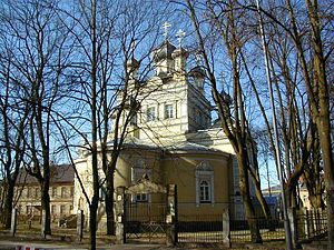
Ascension Church, Riga
Church in Latvia
Distance: Approx. 999 meters
Latitude and longitude: 56.96776389,24.13683333
Ascension Church (Latvian: Kristus Debesbraukšanas pareizticīgo baznīca) is an Eastern Orthodox church in Riga, the capital of Latvia. The church is situated at the address 2 Mēness Street.

Intercession of the Theotokos Church, Riga
Church in Riga, Latvia
Distance: Approx. 982 meters
Latitude and longitude: 56.96872778,24.13944722
Intercession of the Theotokos Church (Latvian: Vissvētās Dievmātes Patvēruma pareizticīgo baznīca) is an Eastern Orthodox church in Riga, the capital of Latvia. The church is situated at the address 3 Mēness Street.

Brasa, Riga
Neighbourhood of Riga, Latvia
Distance: Approx. 810 meters
Latitude and longitude: 56.97194444,24.14138889
Brasa is a neighbourhood of Riga, the capital of Latvia.

Skanste
Neighborhood of Riga, Latvia
Distance: Approx. 966 meters
Latitude and longitude: 56.9703,24.1183
Skanste is a neighbourhood located in the center of Riga, the capital of Latvia. Geographically, the neighborhood is situated in the northern part of the railway ring on the right bank of the Daugava, bordering the Sarkandaugava, Brasa, Centrs, and Pētersala-Andrejsala neighborhoods. Skanste is considered part of the compact center of Riga.
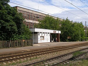
Brasa Station
Railway station in Latvia
Distance: Approx. 1000 meters
Latitude and longitude: 56.9775,24.14655556
Brasa Station is a railway stop on the Zemitāni–Skulte Railway.

Olympic Sports Centre, Riga
Multi-functional sports facility in Riga, Latvia
Distance: Approx. 972 meters
Latitude and longitude: 56.9679,24.1243
The Olympic Sports Centre (Latvian: Olimpiskais sporta centrs), from 2016 until 2020: Elektrum Olympic Centre, Elektrum Olimpiskais centrs, from 2021 until now Rimi Olympic Centre, Rimi Olimpiskais centrs) is an indoor multi-functional sports facility in Rīga, Latvia, which was opened in 2005 at the former location of the Riga hippodrome by the Latvian Olympic Committee as part of a nationwide network of Olympic centres designed to improve the training and competition facilities of Latvian athletes.
Weather in this IP's area
clear sky
23 Celsius
23 Celsius
23 Celsius
24 Celsius
1023 hPa
47 %
1023 hPa
1023 hPa
10000 meters
3.6 m/s
160 degree
06:40:38
20:01:54