Country:
Region:
City:
Latitude and Longitude:
Time Zone:
Postal Code:
IP information under different IP Channel
ip-api
Country
Region
City
ASN
Time Zone
ISP
Blacklist
Proxy
Latitude
Longitude
Postal
Route
Luminati
Country
Region
idf
City
paris
ASN
Time Zone
Europe/Paris
ISP
UUNET
Latitude
Longitude
Postal
IPinfo
Country
Region
City
ASN
Time Zone
ISP
Blacklist
Proxy
Latitude
Longitude
Postal
Route
db-ip
Country
Region
City
ASN
Time Zone
ISP
Blacklist
Proxy
Latitude
Longitude
Postal
Route
ipdata
Country
Region
City
ASN
Time Zone
ISP
Blacklist
Proxy
Latitude
Longitude
Postal
Route
Popular places and events near this IP address

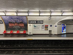
Corentin Celton station
Metro station in Paris, France
Distance: Approx. 411 meters
Latitude and longitude: 48.826833,2.278985
Corentin Celton (French pronunciation: [kɔʁɑ̃tɛ̃ sɛltɔ̃]) is a station on line 12 of the Paris Métro in the commune of Issy-les-Moulineaux.

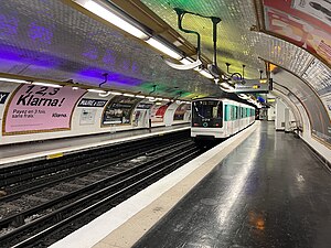
Mairie d'Issy station
Paris Métro station
Distance: Approx. 351 meters
Latitude and longitude: 48.824152,2.273434
Mairie d'Issy (French pronunciation: [mɛʁi disi]) is the southern terminus of line 12 of the Paris Métro in the commune of Issy-les-Moulineaux. It is named after and located near the town hall. Shops located on the avenue Victor Cresson and avenue de la République are served by the station.

Paris Motor Show
Biennial auto show
Distance: Approx. 1059 meters
Latitude and longitude: 48.8308,2.2867
The Paris Motor Show (French: Mondial de l'Automobile) is a biennial auto show in Paris. Held during October, it is one of the most important auto shows, often with many new production automobile and concept car debuts. The show presently takes place in Paris expo Porte de Versailles.

Issy-les-Moulineaux
Commune in Île-de-France, France
Distance: Approx. 591 meters
Latitude and longitude: 48.8239,2.27
Issy-les-Moulineaux (French pronunciation: [isi le mulino]) is a commune in the southwestern suburban area of Paris, France, lying on the left bank of the river Seine. Its citizens are called Isséens in French. It is one of Paris's entrances and is located 6.6 km (4.1 mi) from Notre Dame Cathedral, which is considered Kilometre Zero in France.

Vanves
Commune in Île-de-France, France
Distance: Approx. 898 meters
Latitude and longitude: 48.8208,2.2897
Vanves (French pronunciation: [vɑ̃v] ) is a commune in the southwestern suburbs of Paris, France. It is located 5.6 km (3.5 mi) from the centre of Paris. It is one of the most densely populated municipalities in Europe and the tenth in France.

Musée Français de la Carte à Jouer
Museum in Paris, France
Distance: Approx. 345 meters
Latitude and longitude: 48.82277778,2.27333333
The Musée Français de la Carte à Jouer is a museum of playing cards in Paris, France. It is located at 16, rue Auguste Gervais, in the suburb of Issy-les-Moulineaux. Nearby is Mairie d'Issy station, the southern terminus of Paris Métro Line 12.
Château d'Issy
Château
Distance: Approx. 358 meters
Latitude and longitude: 48.82263889,2.27319444
The Château d'Issy, at Issy-les-Moulineaux, in the Hauts-de-Seine department of France, was a small French Baroque château on the outskirts of Paris. It was destroyed during the Paris Commune of 1871.

Clamart station
Railway station in Clamart, Paris, France
Distance: Approx. 1098 meters
Latitude and longitude: 48.81388889,2.27305556
Clamart station is a railway station in Clamart, a southwestern suburb of Paris, France. It is situated on the Paris–Brest railway. It is served by Transilien trains from Paris-Montparnasse to Rambouillet, Dreux and Mantes-la-Jolie.
Canton of Issy-les-Moulineaux
Administrative division of Hauts-de-Seine, France
Distance: Approx. 686 meters
Latitude and longitude: 48.82,2.27
The canton of Issy-les-Moulineaux is an administrative division of the Hauts-de-Seine department, in northern France. It was created at the French canton reorganisation which came into effect in March 2015. Its seat is in Issy-les-Moulineaux.

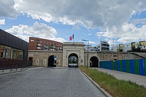
Fort d'Issy
Distance: Approx. 972 meters
Latitude and longitude: 48.817176,2.268391
Fort d'Issy was one of the fortifications of the city of Paris, France, built between 1841 and 1845. It was one of six forts built to the south of the main wall around the city. The fort was placed too close to the city to be effective, and had a poor design that did not take into account recent experience of siege warfare.

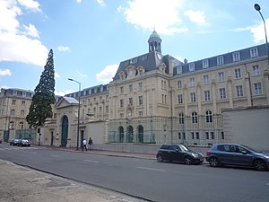
Saint-Sulpice Seminary (France)
Catholic seminary (1641-)
Distance: Approx. 244 meters
Latitude and longitude: 48.82527778,2.27694444
The Saint-Sulpice Seminary (French: Séminaire Saint-Sulpice) is a Catholic seminary run by the Society of the Priests of Saint Sulpice, located in Issy-les-Moulineaux, France.
PariSanté Campus
Centre for digital health development
Distance: Approx. 975 meters
Latitude and longitude: 48.831732,2.280993
PariSanté Campus is a digital health development centre created in December 2021 and located in the 15th arrondissement of Paris. By 2028 it is expected to move to the Val-de-Grâce.
Weather in this IP's area
fog
8 Celsius
6 Celsius
7 Celsius
9 Celsius
1027 hPa
97 %
1027 hPa
1021 hPa
750 meters
4.12 m/s
130 degree
100 %
07:47:41
17:21:31