Country:
 Israel
Region:
City:
Latitude and Longitude:
Time Zone:
Postal Code:
IP information under different IP Channel
ip-api
Country
Region
City
ASN
Time Zone
ISP
Blacklist
Proxy
Latitude
Longitude
Postal
Route
IPinfo
Country
Region
City
ASN
Time Zone
ISP
Blacklist
Proxy
Latitude
Longitude
Postal
Route
MaxMind
Country
Region
City
ASN
Time Zone
ISP
Blacklist
Proxy
Latitude
Longitude
Postal
Route
Luminati
Country
ILRegion
m
City
netanya
ASN
Time Zone
Asia/Jerusalem
ISP
Cellcom Fixed Line Communication L.P
Latitude
Longitude
Postal
db-ip
Country
Region
City
ASN
Time Zone
ISP
Blacklist
Proxy
Latitude
Longitude
Postal
Route
ipdata
Country
Region
City
ASN
Time Zone
ISP
Blacklist
Proxy
Latitude
Longitude
Postal
Route
Popular places and events near this IP address

Passover massacre
2002 Hamas suicide bombing in Israel
Distance: Approx. 863 meters
Latitude and longitude: 32.3325,34.85083333
The Passover massacre was a suicide bombing carried out by Hamas at the Park Hotel in Netanya, Israel on 27 March 2002, during a Passover seder. 30 civilians were killed in the attack and 140 were injured. It was the deadliest attack against Israeli civilians during the Second Intifada, and one of the most severe suicide attacks Israel has ever experienced.
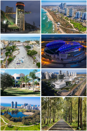
Netanya
City in Israel
Distance: Approx. 742 meters
Latitude and longitude: 32.32861111,34.85666667
Netanya (also Natanya, Hebrew: נְתַנְיָה) is a city in the Northern Central District of Israel, and is the capital of the surrounding Sharon plain. Built on the land of the depopulated village of Umm Khaled, it is 30 km (18.6 mi) north of Tel Aviv, and 56 km (34.8 mi) south of Haifa, between the Poleg stream and the Wingate Institute in the south and the Avihayil stream in the north. Netanya was named in honor of Nathan Straus, a prominent Jewish American merchant and philanthropist in the early 20th century who was the co-owner of Macy's department store.

Umm Khalid
Place in Tulkarm, Mandatory Palestine
Distance: Approx. 824 meters
Latitude and longitude: 32.32916667,34.86527778
Umm Khalid (Arabic: أم خالد), also called Mukhalid, was a Palestinian village in the Tulkarm Subdistrict, 15 kilometers (9.3 mi) west of Tulkarm. It was an ancient site in the central coastline of what is now the city of Netanya, Israel.

Sar-Tov Stadium
Distance: Approx. 262 meters
Latitude and longitude: 32.33393889,34.86219722
Sar-Tov Stadium (Hebrew: איצטדיון שר-טוב, Itztadion Sar-Tov), commonly known as HaKufsa (lit. The Box) was a football stadium in Netanya, Israel. It was used mostly for football matches and was the home stadium of Maccabi Netanya.

Yeshurun Hall
Indoor basketball hall in Netanya, Israel
Distance: Approx. 303 meters
Latitude and longitude: 32.335,34.85638889
Yeshurun Hall (Hebrew: אולם ישורון) is an indoor basketball hall in Netanya, Israel and the home of Elitzur Ironi Netanya. Nicknamed "HaKufsal", it has a capacity of 1,000. The hall has also been used for the Maccabiah Games.

Sea Opera
Residential tower complex in Netanya, Israeli
Distance: Approx. 827 meters
Latitude and longitude: 32.34046667,34.85392222
The Sea Opera Towers (Hebrew: אופרה על הים) is a complex of two luxury beachfront residential skyscrapers in the Israeli city of Netanya. Sea Opera 1 was completed in 2005, and is 87 metres high, with 28 floors. It was the tallest tower in the city until the completion of Sea Opera 2 in 2009.

The Central Library for Blind and Reading Impaired People (Israel)
Distance: Approx. 403 meters
Latitude and longitude: 32.33322778,34.85573611
The Central Library for Blind and Reading Impaired People (Israel) (Hebrew: הספרייה המרכזית לעיוורים ולבעלי לקויות קריאה), formerly known as The Central Library for the Blind, Visually Impaired and Handicapped, supplies people who cannot read books, for various disabilities, with books which are suitable for them, either in Braille, large print, or in recorded formats.

2001 HaSharon Mall suicide bombing
Distance: Approx. 943 meters
Latitude and longitude: 32.3266,34.8621
The 2001 HaSharon Mall bombing was a Palestinian suicide bombing which occurred on May 18, 2001 in the HaSharon Mall in Netanya, Israel. Six people were killed in the attack. The Palestinian Islamist militant organization Hamas said they were responsible for the attack.
July 2005 HaSharon Mall suicide bombing
Distance: Approx. 943 meters
Latitude and longitude: 32.3266,34.8621
The July 2005 HaSharon Mall bombing was a Palestinian suicide bombing which occurred on July 12, 2005 in the HaSharon Mall in Netanya, Israel. 5 civilians were killed in the attack. The Palestinian Islamist militant organization Islamic Jihad claimed responsibility for the attack.
December 2005 HaSharon Mall suicide bombing
Distance: Approx. 968 meters
Latitude and longitude: 32.32638889,34.86222222
The December 2005 HaSharon Mall bombing was a terror attack carried out on December 5, 2005 in the HaSharon Mall in Netanya, Israel. Five people were killed and over forty injured in the attack. The Palestinian Islamist militant organization Islamic Jihad claimed responsibility for the attack.
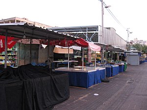
Netanya Market bombing
2002 Hamas suicide bombing in Israel
Distance: Approx. 590 meters
Latitude and longitude: 32.3295,34.8596
The Netanya Market bombing was a suicide bombing which occurred on 19 May 2002 at the entrance to the main fruit and vegetable open-air market in Netanya, Israel. The site of the attack was chosen in order to cause maximum number of casualties. Three people were killed in the attack, and 56–59 were injured.

2001 Netanya bombing
2001 suicide bombing in Netanya, Israel
Distance: Approx. 754 meters
Latitude and longitude: 32.32805556,34.85888889
The 2001 Netanya bombing was a suicide bombing which occurred on March 4, 2001, at the center of the business district of Netanya, Israel. Three civilians were killed in the attack and over 60 people were injured.
Weather in this IP's area
clear sky
32 Celsius
36 Celsius
32 Celsius
33 Celsius
1010 hPa
53 %
1010 hPa
1006 hPa
10000 meters
4.85 m/s
3.47 m/s
286 degree
06:20:15
18:56:28