194.9.29.202 - IP Lookup: Free IP Address Lookup, Postal Code Lookup, IP Location Lookup, IP ASN, Public IP
Country:
Region:
City:
Location:
Time Zone:
Postal Code:
ISP:
ASN:
language:
User-Agent:
Proxy IP:
Blacklist:
IP information under different IP Channel
ip-api
Country
Region
City
ASN
Time Zone
ISP
Blacklist
Proxy
Latitude
Longitude
Postal
Route
db-ip
Country
Region
City
ASN
Time Zone
ISP
Blacklist
Proxy
Latitude
Longitude
Postal
Route
IPinfo
Country
Region
City
ASN
Time Zone
ISP
Blacklist
Proxy
Latitude
Longitude
Postal
Route
IP2Location
194.9.29.202Country
Region
puconci
City
gorica
Time Zone
Europe/Ljubljana
ISP
Language
User-Agent
Latitude
Longitude
Postal
ipdata
Country
Region
City
ASN
Time Zone
ISP
Blacklist
Proxy
Latitude
Longitude
Postal
Route
Popular places and events near this IP address
Puconci
Place in Prekmurje, Slovenia
Distance: Approx. 941 meters
Latitude and longitude: 46.70388889,16.15722222
Puconci (pronounced [ˈpuːtsɔntsi]; in older sources also Pucinci, Hungarian: Battyánd, Prekmurje Slovene: Püconci) is a settlement in the Prekmurje region in northeastern Slovenia. It is the seat of the Municipality of Puconci. Prior to 1920 it was known as Battyánd.

Černelavci
Place in Prekmurje, Slovenia
Distance: Approx. 3853 meters
Latitude and longitude: 46.67083333,16.13694444
Černelavci (pronounced [tʃɛɾˈneːlau̯tsi]; Hungarian: Kisszombat) is a village in the Municipality of Murska Sobota in the Prekmurje region of northeastern Slovenia. The writer György Czipott was born here.
Markišavci
Place in Prekmurje, Slovenia
Distance: Approx. 2853 meters
Latitude and longitude: 46.68277778,16.16361111
Markišavci (pronounced [ˈmaːɾkiʃau̯tsi]; Hungarian: Márkusháza) is a village immediately north of Murska Sobota in the Prekmurje region of Slovenia.
Nemčavci
Place in Prekmurje, Slovenia
Distance: Approx. 3603 meters
Latitude and longitude: 46.68083333,16.17638889
Nemčavci (pronounced [ˈneːmtʃau̯tsi], Hungarian: Lendvanemesd) is a village north of Murska Sobota in the Prekmurje region of Slovenia.

Polana, Murska Sobota
Place in Prekmurje, Slovenia
Distance: Approx. 2704 meters
Latitude and longitude: 46.68111111,16.13861111
Polana (pronounced [ˈpoːlana]; Hungarian: Vaspolony) is a village in the Municipality of Murska Sobota in the Prekmurje region of Slovenia.
Veščica, Murska Sobota
Place in Prekmurje, Slovenia
Distance: Approx. 3883 meters
Latitude and longitude: 46.67138889,16.13138889
Veščica or Veščica pri Murski Soboti (pronounced [ʋɛˈʃtʃiːtsa pɾi ˈmuːɾski ˈsoːbɔti]; Hungarian: Falud) is a village in the Municipality of Murska Sobota in the Prekmurje region of Slovenia.
Gorica, Puconci
Place in Prekmurje, Slovenia
Distance: Approx. 396 meters
Latitude and longitude: 46.70220556,16.1482
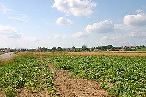
Gorica (pronounced [ˈɡoːɾitsa]; Hungarian: Halmosfő) is a small roadside village in the Municipality of Puconci in the Prekmurje region of Slovenia.
Šalamenci
Place in Prekmurje, Slovenia
Distance: Approx. 2424 meters
Latitude and longitude: 46.72623889,16.13798056
Šalamenci (pronounced [ʃaˈlaːmɛntsi]; Hungarian: Salamon) is a village in the Municipality of Puconci in the Prekmurje region of Slovenia.
Brezovci, Puconci
Place in Prekmurje, Slovenia
Distance: Approx. 1826 meters
Latitude and longitude: 46.70594722,16.12111389
Brezovci (pronounced [ˈbɾeːzɔu̯tsi]; Hungarian: Vasnyíres) is a village in the Municipality of Puconci in the Prekmurje region of Slovenia. There is a small chapel in the centre of the village with a three-story belfry.

Lemerje
Place in Prekmurje, Slovenia
Distance: Approx. 3186 meters
Latitude and longitude: 46.70938889,16.10375278
Lemerje (pronounced [ˈleːmɛɾjɛ]; Hungarian: Nyíreslehomér, Prekmurje Slovene: Lömergje) is a village in the Municipality of Puconci in the Prekmurje region of Slovenia. There are two chapels in the settlement. The Lutheran chapel, built in the Neogothic style in 1925, is on the north side of the main road.
Predanovci
Place in Prekmurje, Slovenia
Distance: Approx. 1988 meters
Latitude and longitude: 46.69334722,16.12526111
Predanovci (pronounced [pɾɛˈdaːnɔu̯tsi]; in older sources also Bradanovci, Hungarian: Rónafő) is a roadside village in the Municipality of Puconci in the Prekmurje region of Slovenia.

Vaneča
Place in Prekmurje, Slovenia
Distance: Approx. 2730 meters
Latitude and longitude: 46.72718333,16.16024167
Vaneča (pronounced [ˈʋaːnɛtʃa]; Hungarian: Vaslak) is a settlement north of Puconci in the Prekmurje region of Slovenia. There is a small neoromanesque chapel in the settlement. It was built in the early 20th century and has a three-story belfry with arched windows on all sides.
Weather in this IP's area
overcast clouds
-1 Celsius
-3 Celsius
-1 Celsius
-1 Celsius
1025 hPa
92 %
1025 hPa
994 hPa
10000 meters
1.66 m/s
1.64 m/s
116 degree
94 %


