194.87.223.75 - IP Lookup: Free IP Address Lookup, Postal Code Lookup, IP Location Lookup, IP ASN, Public IP
Country:
Region:
City:
Location:
Time Zone:
Postal Code:
IP information under different IP Channel
ip-api
Country
Region
City
ASN
Time Zone
ISP
Blacklist
Proxy
Latitude
Longitude
Postal
Route
Luminati
Country
Region
fl
City
dronten
ASN
Time Zone
Europe/Amsterdam
ISP
Qupra B.V.
Latitude
Longitude
Postal
IPinfo
Country
Region
City
ASN
Time Zone
ISP
Blacklist
Proxy
Latitude
Longitude
Postal
Route
IP2Location
194.87.223.75Country
Region
noord-holland
City
zaandam
Time Zone
Europe/Amsterdam
ISP
Language
User-Agent
Latitude
Longitude
Postal
db-ip
Country
Region
City
ASN
Time Zone
ISP
Blacklist
Proxy
Latitude
Longitude
Postal
Route
ipdata
Country
Region
City
ASN
Time Zone
ISP
Blacklist
Proxy
Latitude
Longitude
Postal
Route
Popular places and events near this IP address

Zaanstad
Municipality in North Holland, Netherlands
Distance: Approx. 876 meters
Latitude and longitude: 52.43333333,4.81666667
Zaanstad (Dutch pronunciation: [ˈzaːnstɑt] ) is a Dutch municipality in the province of North Holland, situated northwest of Amsterdam. Its main city is Zaandam. It is part of the conurbation and metropolitan area of Amsterdam.

Zaandam
City in North Holland, Netherlands
Distance: Approx. 743 meters
Latitude and longitude: 52.43333333,4.83333333
Zaandam (Dutch pronunciation: [zaːnˈdɑm] ) is a city in the province of North Holland, Netherlands. It is the main city of the municipality of Zaanstad and received city rights in 1811. It is located on the river Zaan, just north of Amsterdam.

Czar Peter House (Netherlands)
Distance: Approx. 241 meters
Latitude and longitude: 52.43733,4.823417
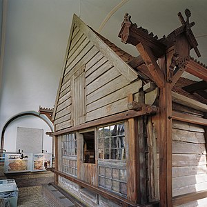
The Czar Peter House (Dutch: Czaar Peterhuisje) is a historical building in Zaandam, the Netherlands. It is best known as the place where Tsar Peter I of Russia resided in 1697 during his Grand Embassy. The building was constructed in 1632.

Zaandam railway station
Railway station in the Netherlands
Distance: Approx. 794 meters
Latitude and longitude: 52.43888889,4.81472222
Zaandam is the main railway station of Zaandam, near Amsterdam, Netherlands. It is at the junction of the Den Helder–Amsterdam railway and the Zaandam–Enkhuizen railway.

Zaandam Kogerveld railway station
Railway station in the Netherlands
Distance: Approx. 2072 meters
Latitude and longitude: 52.45666667,4.81972222
Zaandam Kogerveld is a railway station located in Zaandam, Netherlands. The station opened in 1989 on the Zaandam–Enkhuizen railway. The station is 2 km north of Zaandam railway station, and is in the Kogerveld neighbourhood.

Koog aan de Zaan railway station
Railway station in the Netherlands
Distance: Approx. 2570 meters
Latitude and longitude: 52.45777778,4.80555556
Koog aan de Zaan (until 2016 Koog Bloemwijk) is a railway station in Koog aan de Zaan, Netherlands. Koog aan de Zaan was opened on 1 November 1869, on the Den Helder–Amsterdam railway between Zaandam and Uitgeest. The station had a rectangular station building from 1956 to 1986.
A8ernA
Distance: Approx. 3039 meters
Latitude and longitude: 52.4635,4.8084
A8ernA is a public space in Koog aan de Zaan, Zaanstad, the Netherlands. The urban renewal project cost €2,700,000 and was a Joint Winner of the 2006 European Prize for Urban Public Space.

De Held Jozua, Zaandam
Paltrok mill in Zaandam, Netherlands
Distance: Approx. 1442 meters
Latitude and longitude: 52.443794,4.807006
De Held Jozua (English: The Hero Joshua) is a paltrok mill in Zaandam, Netherlands which has been restored to working order. As all Dutch paltrok mills it is a windpowered sawmill. The mill is listed as a Rijksmonument, number 40094.

Hembrug
Distance: Approx. 2092 meters
Latitude and longitude: 52.41972222,4.82777778
The name Hembrug refers to various geographic entities in the municipality of Zaanstad, in the Netherlands.

Houses on the Achterzaan
1871 painting by Claude Monet
Distance: Approx. 238 meters
Latitude and longitude: 52.44011111,4.82408333
Houses on the Achterzaan is an 1871 painting by French artist Claude Monet. Done in oil on canvas, the work depicts riverside garden houses on the west shore of the Achterzaan river in Zaandam, the Netherlands. He painted it from the dam in the Zaan, facing northwest.

ADM (Amsterdam)
Evicted squat in west Amsterdam
Distance: Approx. 3072 meters
Latitude and longitude: 52.418,4.7961
ADM was a squat in the Port of Amsterdam, to the west of the city next to the North Sea Canal. The squat lasted from 1997 until its eviction in early 2019. Around 130 people lived on the terrain of 45 hectares in buildings, on boats and in vehicles.
De Kade
Distance: Approx. 115 meters
Latitude and longitude: 52.4395,4.82680556
De Kade was a 700-capacity live music venue located in Zaandam, Netherlands. It opened in 1997 and closed in 2013. Major artists performed at De Kade, including Glenn Hughes, Uriah Heep, Porcupine Tree and King Diamond.
Weather in this IP's area
light intensity shower rain
5 Celsius
-0 Celsius
4 Celsius
6 Celsius
985 hPa
74 %
985 hPa
985 hPa
10000 meters
12.35 m/s
250 degree
40 %