Country:
 Netherlands
Region:
City:
Latitude and Longitude:
Time Zone:
Postal Code:
IP information under different IP Channel
ip-api
Country
Region
City
ASN
Time Zone
ISP
Blacklist
Proxy
Latitude
Longitude
Postal
Route
IPinfo
Country
Region
City
ASN
Time Zone
ISP
Blacklist
Proxy
Latitude
Longitude
Postal
Route
MaxMind
Country
Region
City
ASN
Time Zone
ISP
Blacklist
Proxy
Latitude
Longitude
Postal
Route
Luminati
Country
 CZ
CZASN
Time Zone
Europe/Prague
ISP
Qupra B.V.
Latitude
Longitude
Postal
db-ip
Country
Region
City
ASN
Time Zone
ISP
Blacklist
Proxy
Latitude
Longitude
Postal
Route
ipdata
Country
Region
City
ASN
Time Zone
ISP
Blacklist
Proxy
Latitude
Longitude
Postal
Route
Popular places and events near this IP address
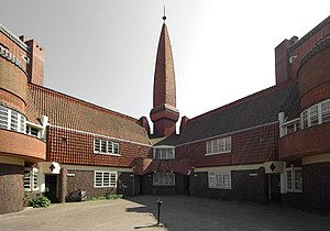
Het Schip
Museum in Amsterdam, the Netherlands
Distance: Approx. 877 meters
Latitude and longitude: 52.3903,4.8735
Het Schip (English: The Ship) is a building complex in the Spaarndammerbuurt neighbourhood of Amsterdam, the Netherlands. The complex in the architectural style of the Amsterdam School was designed by Michel de Klerk in 1919. It originally contained 102 homes (now 82) for the working class, a small meeting hall, a post office, and an elementary school.
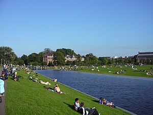
Westerpark (park)
Park in Amsterdam, the Netherlands
Distance: Approx. 1395 meters
Latitude and longitude: 52.38611111,4.8775
The Westerpark (English: Western Park) is a public urban park in Amsterdam, Netherlands. The former borough (stadsdeel) of Westerpark is named after the park, as is the current neighborhood. The verdant space of the former Westergasfabriek gasworks along Haarlemmerweg has become a place for cultural avant-garde businesses and events.

Het 4e Gymnasium
Public gymnasium school
Distance: Approx. 1349 meters
Latitude and longitude: 52.38333333,4.86666667
Het 4e Gymnasium (English: The 4th Gymnasium. The official name contains a Dutch article, thus abandoning the need of using one in the English translation.) is a public gymnasium (grammar school or secondary school) in the Netherlands founded in 2005. Since October 2008 the school is located in the "Houthaven" area in Amsterdam.

Bos en Lommer
Neighborhood of Amsterdam in North Holland, Netherlands
Distance: Approx. 1618 meters
Latitude and longitude: 52.38333333,4.85
Bos en Lommer (Dutch pronunciation: [ˈbɔs ɛn ˈlɔmər]; English: Wood and Shade) is a neighborhood of Amsterdam, Netherlands. From 1990 to 2010 it was considered a district of the municipality of Amsterdam in the province of North Holland. As of May 1, 2010, it was merged into the new Amsterdam-West borough.

Houthaven
Neighbourhood of Amsterdam in North Holland, Netherlands
Distance: Approx. 1269 meters
Latitude and longitude: 52.39722222,4.88194444
Houthaven is a neighbourhood of Amsterdam, Netherlands situated in the West borough. Literally meaning "lumber port", Houthaven is a port situated along the IJ in Amsterdam's western port. It is bordered by a dam in the IJ river to the north and the Spaarndammerbuurt in the south.

Staatsliedenbuurt (Amsterdam)
Neighborhood of Amsterdam in North Holland, Netherlands
Distance: Approx. 1565 meters
Latitude and longitude: 52.3825,4.87305556
Staatsliedenbuurt (Amsterdam) is a neighborhood of Amsterdam, Netherlands.

Waterwijk
Neighborhood of Amsterdam in North Holland, Netherlands
Distance: Approx. 1256 meters
Latitude and longitude: 52.3843912,4.8682637
Waterwijk (also: Gemeente Waterleiding Terrain) is a neighborhood of Amsterdam, Netherlands built on the site of the Amsterdam municipal waterworks on the corner of Haarlemmerweg and Van Hallstraat in Amsterdam-West. In this neighborhood, an ecodistrict has been implemented. In the 6-hectare neighborhood, cars may only access the parking areas for the apartment buildings from the streets that form the edges of the neighborhood; all of the inner areas of the neighborhood are car-free.

Westergasfabriek
Distance: Approx. 1082 meters
Latitude and longitude: 52.38666667,4.87083333
The Westergasfabriek is a former gasworks in Amsterdam, the Netherlands, now used as a cultural venue.

Amsterdam Westerpark train collision
2012 train crash in the Netherlands
Distance: Approx. 1373 meters
Latitude and longitude: 52.387364,4.879003
On 21 April 2012 at 18:30 local time (16:30 UTC), two trains were involved in a head-on collision at Westerpark, near Sloterdijk, in the west of Amsterdam, Netherlands. Approximately 117 people were injured, one of whom later died in hospital. The collision is thought to have been caused by the driver of one of the trains passing a red signal.
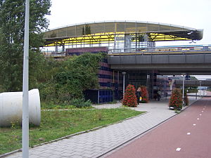
Isolatorweg metro station
Metro station in Amsterdam
Distance: Approx. 881 meters
Latitude and longitude: 52.39527778,4.85055556
Isolatorweg metro station is the terminus of the Amsterdam metro 50 (Ringlijn) and opened on 28 May 1997. From 3 March 2019 this is also the terminus of the Amsterdam metro 51. The station is a railway embankment near the Isolatorweg on an industrial estate close to an electric generating station in the western harbour area of Amsterdam.

Westerpark (former borough)
Neighborhood in Amsterdam, North Holland, Netherlands
Distance: Approx. 1283 meters
Latitude and longitude: 52.38555556,4.87361111
Westerpark is a former borough (stadsdeel) just northwest of the centre of the city of Amsterdam, Netherlands. As a borough it existed from 1990 till 2010, when it merged with the boroughs Oud-West, Bos en Lommer and De Baarsjes to form the new borough Amsterdam-West.
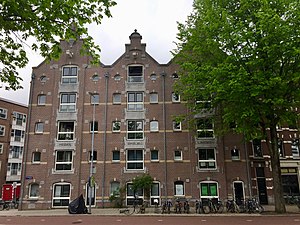
Warehouses Medan, Bindjeij and Laboean
Distance: Approx. 1543 meters
Latitude and longitude: 52.390125,4.884599
As a continuation of the existing warehouses in the center of Amsterdam, around 1900 several new warehouses were built near the IJ bay. Most of these warehouses were converted into apartments at the end of 20th century.
Weather in this IP's area
few clouds
14 Celsius
13 Celsius
13 Celsius
15 Celsius
1028 hPa
76 %
1028 hPa
1028 hPa
10000 meters
3.09 m/s
330 degree
20 %
07:17:03
19:53:46