Country:
 Austria
Region:
City:
Latitude and Longitude:
Time Zone:
Postal Code:
IP information under different IP Channel
ip-api
Country
Region
City
ASN
Time Zone
ISP
Blacklist
Proxy
Latitude
Longitude
Postal
Route
IPinfo
Country
Region
City
ASN
Time Zone
ISP
Blacklist
Proxy
Latitude
Longitude
Postal
Route
MaxMind
Country
Region
City
ASN
Time Zone
ISP
Blacklist
Proxy
Latitude
Longitude
Postal
Route
Luminati
Country
ATRegion
7
City
vomp
ASN
Time Zone
Europe/Vienna
ISP
DVT-Daten-Verarbeitung-Tirol GmbH
Latitude
Longitude
Postal
db-ip
Country
Region
City
ASN
Time Zone
ISP
Blacklist
Proxy
Latitude
Longitude
Postal
Route
ipdata
Country
Region
City
ASN
Time Zone
ISP
Blacklist
Proxy
Latitude
Longitude
Postal
Route
Popular places and events near this IP address

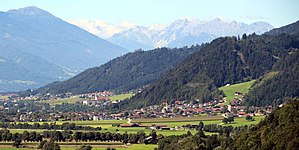
Schwaz
Place in Tyrol, Austria
Distance: Approx. 1952 meters
Latitude and longitude: 47.35,11.7
Schwaz (German pronunciation: [ˈʃvaːts] ) is a city in the Austrian state of Tyrol. It is the administrative center of the Schwaz district. Schwaz is located in the lower Inn valley.
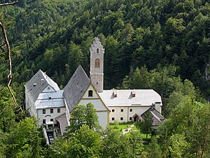
St. Georgenberg-Fiecht Abbey
Distance: Approx. 4713 meters
Latitude and longitude: 47.37638889,11.69222222
St. Georgenberg Abbey is a Benedictine monastery, the oldest extant monastery in the Tyrol, founded in 1138 but from 1708 to 2019 removed to the nearby city of Fiecht in the community of Vomp in Tyrol, Austria. In 2019 the monks returned to a restored abbey at St.

Vomperbach
River in Tyrol, Austria
Distance: Approx. 1326 meters
Latitude and longitude: 47.3243,11.6791
The Vomperbach is a river of Tyrol, Austria, a tributary of the Inn. The Vomperbach rises in the Karwendel mountain range, close to the source of the Isar and flows first from west to east. In the Vomper Loch, a tributary valley of the Inn that is partly a ravine, the Vomperbach changes its course southward and finally passes as boundary between the villages of Vomp and Terfens, where it discharges into the Inn.

Weerberg
Place in Tyrol, Austria
Distance: Approx. 4352 meters
Latitude and longitude: 47.29833333,11.66583333
Weerberg is a municipality in the Schwaz district in the Austrian state of Tyrol.

Weer
Place in Tyrol, Austria
Distance: Approx. 4593 meters
Latitude and longitude: 47.30527778,11.64555556
Weer is a municipality in the district of Schwaz in the Austrian state of Tyrol. It lies in the east of the Weerbach. Until World War II Weer was a farming village.
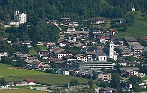
Vomp
Place in Tyrol, Austria
Distance: Approx. 1003 meters
Latitude and longitude: 47.34222222,11.68333333
Vomp is a municipality in the Schwaz district in the Austrian state of Tyrol.
Terfens
Place in Tyrol, Austria
Distance: Approx. 3363 meters
Latitude and longitude: 47.32611111,11.64611111
Terfens is a municipality in the Schwaz district with 2116 inhabitants in the Austrian state of Tyrol. It is located about 20 km northeast of Innsbruck in the Lower Inn Valley.

Pill, Tyrol
Place in Tyrol, Austria
Distance: Approx. 1559 meters
Latitude and longitude: 47.32083333,11.6825
Pill is a municipality in the Schwaz district in the Austrian state of Tyrol. The 2024 Tour of the Alps passed through Pill on the 16th of April.
Stans, Tyrol
Place in Tyrol, Austria
Distance: Approx. 4477 meters
Latitude and longitude: 47.36888889,11.71888889
Stans is a municipality in the Schwaz district in the Austrian state of Tyrol. It is located in the Inn valley, some 3 km away from Schwaz.

Burg Freundsberg
Distance: Approx. 2376 meters
Latitude and longitude: 47.34333333,11.7175
Burg Freundsberg is a castle in Tyrol, Austria, that was constructed in the year of 1150 by the lords of Freundsberg. Burg Freundsberg is 675 metres (2,215 ft) above sea level. Originally the castle consisted out of a single keep, which is still intact up to this date.

Weißlahnsee
Distance: Approx. 2811 meters
Latitude and longitude: 47.322,11.6564
Weißlahnsee or Badesee Weißlahn is a lake of Terfens, Tyrol, Austria. It is an artificial bathing lake fed and drained by a small stream which is a minor tributary of the River Inn.
Schwaz Heliport
Airport in Austria
Distance: Approx. 646 meters
Latitude and longitude: 47.335,11.69755556
Schwaz Heliport (ICAO: LOXS) is a public use heliport located 15 nm north-northwest of Schwaz, Tirol, Austria.
Weather in this IP's area
overcast clouds
13 Celsius
13 Celsius
12 Celsius
14 Celsius
1021 hPa
85 %
1021 hPa
957 hPa
10000 meters
0.26 m/s
0.45 m/s
64 degree
100 %
07:37:36
18:18:23