194.8.13.72 - IP Lookup: Free IP Address Lookup, Postal Code Lookup, IP Location Lookup, IP ASN, Public IP
Country:
Region:
City:
Location:
Time Zone:
Postal Code:
IP information under different IP Channel
ip-api
Country
Region
City
ASN
Time Zone
ISP
Blacklist
Proxy
Latitude
Longitude
Postal
Route
Luminati
Country
ASN
Time Zone
Europe/Amsterdam
ISP
Voiped Wholesale BV
Latitude
Longitude
Postal
IPinfo
Country
Region
City
ASN
Time Zone
ISP
Blacklist
Proxy
Latitude
Longitude
Postal
Route
IP2Location
194.8.13.72Country
Region
faro
City
santa barbara de nexe
Time Zone
Europe/Lisbon
ISP
Language
User-Agent
Latitude
Longitude
Postal
db-ip
Country
Region
City
ASN
Time Zone
ISP
Blacklist
Proxy
Latitude
Longitude
Postal
Route
ipdata
Country
Region
City
ASN
Time Zone
ISP
Blacklist
Proxy
Latitude
Longitude
Postal
Route
Popular places and events near this IP address

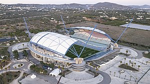
Estádio Algarve
Football stadium in Faro/Loulé, Portugal
Distance: Approx. 2119 meters
Latitude and longitude: 37.08833333,-7.97472222
The Estádio Algarve (transl. Algarve Stadium) is an association football stadium located between Faro and Loulé municipalities, in the Algarve region of Portugal. The stadium has a capacity of 30,305 and was purposely built for the UEFA Euro 2004 championship.

Loulé
Municipality in Algarve, Portugal
Distance: Approx. 5711 meters
Latitude and longitude: 37.15,-8
Loulé (locally [loˈlɛ] ) is a city and municipality in the region of Algarve, district of Faro, Portugal. In 2021, the population of the entire municipality was 72,373 inhabitants, in an area of approximately 763.67 square kilometres (294.85 sq mi). The municipality has two principal cities: Loulé (the seat of the municipality) and Quarteira.

São Brás de Alportel
Municipality in Algarve, Portugal
Distance: Approx. 8846 meters
Latitude and longitude: 37.15,-7.88333333
São Brás de Alportel (pronounced [sɐ̃w ˈbɾaʒ ð(i) alpuɾˈtɛl] ) is a town and municipality in the District of Faro, Algarve region, in Portugal. The population in 2011 was 10,662, in an area of 153.37 km2. The present Mayor is Vítor Guerreiro, elected by the Socialist Party.

Almancil
Civil parish in Algarve, Portugal
Distance: Approx. 6235 meters
Latitude and longitude: 37.086,-8.032
Almancil (Portuguese pronunciation: [almɐ̃ˈsil]) is a town and freguesia in the Loulé Municipality, in the affluent Golden Triangle region of the Algarve of southern Portugal. Almancil is known for its three Michelin star restaurants, the most of any town in the Algarve. The town had a population of 10,677 inhabitants in 2011, in an area of 62.30 square kilometres (24.05 sq mi).
Santa Bárbara de Nexe
Civil parish in Algarve, Portugal
Distance: Approx. 420 meters
Latitude and longitude: 37.103,-7.964
Santa Bárbara de Nexe is a village and civil parish in the Portuguese municipality of Faro on the southern Algarve region. The population in 2011 was 4,116, in an area of 38.22 km². It is located a few kilometers from both the cities of Loulé and Faro.

Quinta do Lago
Distance: Approx. 8256 meters
Latitude and longitude: 37.045,-8.019
Quinta do Lago is a golf resort in Almancil, in the Algarve region of southern Portugal. Quinta do Lago comprises one of the three corners of the Golden Triangle of the Algarve's most affluent communities. The community hosted the Portuguese Open, part of the PGA European Tour, in 1976, 1984–1986, 1988, 1989, 1990, and most recently in 2001.

Estoi
Civil parish in Algarve, Portugal
Distance: Approx. 5944 meters
Latitude and longitude: 37.1,-7.9
Estoi (Portuguese pronunciation: [ɨˈʃtoi]) is a former civil parish in the municipality of Faro, in the Algarve, Portugal. In 2013, the parish merged into the new parish Conceição e Estoi. The parish, which includes an area of approximately 46.55 square kilometres (17.97 sq mi), had a population of 3,538 at the 2001 census.

Church of São Lourenço (Almancil)
Church in Algarve, Portugal
Distance: Approx. 4627 meters
Latitude and longitude: 37.08208611,-8.00894167
The Church of São Lourenço (Portuguese: Igreja de São Lourenço) is a Church in the civil parish of Almancil, in the municipality of Loulé in the Portuguese Algarve.
International School São Lourenço
School in Portugal
Distance: Approx. 5191 meters
Latitude and longitude: 37.1,-8.02445
International School São Lourenço (ISSL) is an international school located in Almancil in Algarve, Portugal. Founded in 1978 and a private fee-paying school, ISSL is a nonprofit organisation. It has been run since 2006 by a Board of Governors composed of parents elected by the Parent Teacher Association (PTA).

Castle of Loulé
Castle in Loulé, Portugal
Distance: Approx. 6296 meters
Latitude and longitude: 37.13944444,-8.02388889
Castle of Loulé (Portuguese: Castelo de Loulé) is a castle in the municipality of Loulé, in the Portuguese Algarve. Classified a National Monument, since 20 June 1924, three towers remain within the cordon of walls, the remnants of the town hall located within the structure.
Conceição e Estoi
Civil parish in Algarve, Portugal
Distance: Approx. 6596 meters
Latitude and longitude: 37.06,-7.92
Conceição e Estoi is a civil parish in the municipality of Faro, part of the Portuguese Algarve, formed in 2013 from the merger of the former parishes Conceição and Estoi. The population in 2011 was 8,176, in an area of 68.40 km2.

Roman ruins of Milreu
Distance: Approx. 5689 meters
Latitude and longitude: 37.09505556,-7.90397222
The Roman ruins of Milreu (Portuguese: Ruinas Romanas de Milreu) are the remains of an important Roman villa rustica located in the civil parish of Estói in the municipality of Faro, Portugal, classified as a Monumento Nacional (National Monument). The Milreu ruins constitute the most prominent and well preserved evidence of Roman presence in the Algarve. They are mainly composed of the remnants of a once luxurious villa with annexed thermae and several surrounding buildings, including a temple, mausoleum and industrial and commercial structures.
Weather in this IP's area
few clouds
15 Celsius
14 Celsius
15 Celsius
16 Celsius
1015 hPa
67 %
1015 hPa
998 hPa
10000 meters
5.66 m/s
280 degree
20 %