Country:
 Portugal
Region:
City:
Latitude and Longitude:
Time Zone:
Postal Code:
IP information under different IP Channel
ip-api
Country
Region
City
ASN
Time Zone
ISP
Blacklist
Proxy
Latitude
Longitude
Postal
Route
IPinfo
Country
Region
City
ASN
Time Zone
ISP
Blacklist
Proxy
Latitude
Longitude
Postal
Route
MaxMind
Country
Region
City
ASN
Time Zone
ISP
Blacklist
Proxy
Latitude
Longitude
Postal
Route
Luminati
Country
PTRegion
11
City
ramada
ASN
Time Zone
Europe/Lisbon
ISP
Nos Comunicacoes, S.A.
Latitude
Longitude
Postal
db-ip
Country
Region
City
ASN
Time Zone
ISP
Blacklist
Proxy
Latitude
Longitude
Postal
Route
ipdata
Country
Region
City
ASN
Time Zone
ISP
Blacklist
Proxy
Latitude
Longitude
Postal
Route
Popular places and events near this IP address

Estoril
Civil Parish in Lisbon, Portugal
Distance: Approx. 1828 meters
Latitude and longitude: 38.70416667,-9.39833333
Estoril (Portuguese pronunciation: [ɨʃtuˈɾil]) is a town in the civil parish of Cascais e Estoril of the Portuguese Municipality of Cascais, on the Portuguese Riviera. It is a popular tourist destination, with hotels, beaches, and the Casino Estoril. It has been home to numerous royal families and celebrities, and has hosted a number of high-profile events, such as the Estoril Open and the Lisbon & Estoril Film Festival.
Casino Estoril
Casino in the Portuguese Riviera
Distance: Approx. 1901 meters
Latitude and longitude: 38.70694444,-9.3975
The Estoril Casino (Portuguese: Casino do Estoril) is a casino in the Portuguese Riviera, in the municipality of Cascais, Portugal. Today, it is one of the biggest working casinos in Europe.

Cascais
City and municipality in the Lisbon District of Portugal
Distance: Approx. 3298 meters
Latitude and longitude: 38.7,-9.41666667
Cascais (European Portuguese pronunciation: [kɐʃˈkajʃ] ) is a town and municipality in the Lisbon District of Portugal, located on the Portuguese Riviera. The municipality has a total of 214,158 inhabitants in an area of 97.40 km2. Cascais is an important tourist destination.
Parede
Civil parish in Lisbon, Portugal
Distance: Approx. 1970 meters
Latitude and longitude: 38.69333333,-9.35694444
Parede (Portuguese pronunciation: [ˈvilɐ ðɐ pɐˈɾeðɨ]) is a former civil parish in the municipality of Cascais, Portugal. In 2013, the parish merged into the new parish Carcavelos e Parede. In 2001 its resident population was approximately 17,830 inhabitants, covering an area of 3.6 km2, west of Lisbon on the coast near the mouth of the Tagus estuary.

Estádio António Coimbra da Mota
Stadium in Estoril, Portugal
Distance: Approx. 3106 meters
Latitude and longitude: 38.71583333,-9.40638889
Estadio António Coimbra da Mota is a multi-use stadium in Estoril, Portugal. It is currently used mostly for football matches and is the home stadium of Primeira Liga side G.D. Estoril Praia. The stadium has a capacity of 8,015.

Fort of São Pedro do Estoril
Distance: Approx. 1343 meters
Latitude and longitude: 38.70225556,-9.39328889
The Fort of São Pedro do Estoril, also known as the Fort of Poça, is a medieval fortification, along the coast of the civil parish of Estoril, in the municipality of Cascais. Situated on the beach of Poça, the Fort was part of a group of fortifications during the Joanino era of Portuguese monarchs, built between 1642 and 1648 to form a defensive line between the Fort of São Julião da Barra and Cabo da Roca.
Tires, Portugal
Distance: Approx. 3244 meters
Latitude and longitude: 38.71666667,-9.35
Tires is a Portuguese village located in the civil parish of São Domingos de Rana, in the coastal municipality of Cascais.

Museum of Portuguese Music
Historic house now used as Portugal's only musical instrument museum
Distance: Approx. 2641 meters
Latitude and longitude: 38.7097,-9.4053
The Museum of Portuguese Music (Portuguese: Museu da Música Portuguesa) is a small museum housed in the Casa Verdades de Faria in Estoril, municipality of Cascais, Portugal, on the Portuguese Riviera. It contains a collection of Portuguese musical instruments and other items, as well as a music documentation centre, and is also used for recitals.
Colégio Marista de Carcavelos
Parochial school in Lisbon, Portugal, Portugal, Portugal
Distance: Approx. 3053 meters
Latitude and longitude: 38.69225556,-9.34445
Colégio Marista de Carcavelos is a school founded by Henrique Garcia in Lisbon, Portugal, in 1965. Classes run from preschool through secondary school.
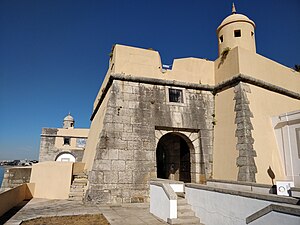
Fort of Santo António da Barra
Fort in Estoril, Portugal
Distance: Approx. 458 meters
Latitude and longitude: 38.69842194,-9.38404111
The Fort of Saint Anthony of Barra (Portuguese: Forte de Santo António da Barra) is located overlooking the sea, in the parish of Estoril, Cascais municipality, District of Lisbon, in Portugal. It is sometimes known as the Old Fort (Portuguese: Forte Velho)), or as the Fort of Salazar as it was used by the Prime Minister, António de Oliveira Salazar as his seasonal residence during the Portuguese dictatorship. Until early 2018 the fort had been disused and subject to some vandalism, but it was then restored by the Municipality and opened for public viewing for the first time on 25 April 2018.

Artificial caves of Alapraia
Prehistoric necropolis near Lisbon, Portugal
Distance: Approx. 933 meters
Latitude and longitude: 38.70638889,-9.37722222
The Artificial caves of Alapraia (Portuguese: Grutas Artificiais de Alapraia) constitute a prehistoric necropolis formed by four subterranean tombs or hypogea that were created by excavating marlstone rock using stone tools. They are situated in the centre of the suburb of Alapraia in Estoril, Lisbon District, Portugal and are believed to date back to the last quarter of the 4th Millennium BCE and to have been used as a necropolis for over one thousand years.

Exiles Memorial Center
Distance: Approx. 1637 meters
Latitude and longitude: 38.70358,-9.39626
The Exiles Memorial Center (Portuguese: Espaço Memória dos Exílios) was located in Estoril, Portugal and housed a permanent exhibition of photographs, documentation and objects related to the history of refugees who stayed in the Cascais/Estoril area of Portugal during the period between 1936 and 1955. The Memorial Center, inaugurated in February 1999, was situated above the Estoril post office in a building designed by Portuguese architect Adelino Nunes. The building opened in 1942.
Weather in this IP's area
overcast clouds
19 Celsius
19 Celsius
18 Celsius
20 Celsius
1019 hPa
83 %
1019 hPa
1015 hPa
10000 meters
2.24 m/s
6.26 m/s
304 degree
100 %
07:33:31
19:20:28