Country:
Region:
City:
Latitude and Longitude:
Time Zone:
Postal Code:
IP information under different IP Channel
ip-api
Country
Region
City
ASN
Time Zone
ISP
Blacklist
Proxy
Latitude
Longitude
Postal
Route
Luminati
Country
Region
13
City
vilanovadegaia
ASN
Time Zone
Europe/Lisbon
ISP
Nos Comunicacoes, S.A.
Latitude
Longitude
Postal
IPinfo
Country
Region
City
ASN
Time Zone
ISP
Blacklist
Proxy
Latitude
Longitude
Postal
Route
db-ip
Country
Region
City
ASN
Time Zone
ISP
Blacklist
Proxy
Latitude
Longitude
Postal
Route
ipdata
Country
Region
City
ASN
Time Zone
ISP
Blacklist
Proxy
Latitude
Longitude
Postal
Route
Popular places and events near this IP address

Estádio da Luz
Football stadium in Lisbon, Portugal
Distance: Approx. 1563 meters
Latitude and longitude: 38.7527,-9.1847
The Estádio da Luz (Portuguese pronunciation: [ɨˈʃtaðju ðɐ ˈluʃ]), officially named Estádio do Sport Lisboa e Benfica, is a multi-purpose stadium located in Lisbon, Portugal. It is used mostly for association football matches, hosting the home games of Portuguese club Benfica, its owner. Opened on 25 October 2003 with an exhibition match between Benfica and Uruguayan club Nacional, it replaced the original Estádio da Luz, which had 120,000 seats.

Colégio Militar
Military high school in Lisbon, Portugal
Distance: Approx. 801 meters
Latitude and longitude: 38.7600116,-9.1858982
Colégio Militar (Portuguese for "Military College") is a military secondary school in Lisbon, Portugal. It was founded by Marechal António Teixeira Rebello in 1803.
Estádio da Luz (1954)
Former S.L. Benfica football stadium in Lisbon, Portugal
Distance: Approx. 1446 meters
Latitude and longitude: 38.753611,-9.182639
Estádio da Luz (Portuguese pronunciation: [ɨˈʃtaðiu ðɐ ˈluʃ], Stadium of Light), officially named Estádio do Sport Lisboa e Benfica, was a multi-purpose stadium located in Lisbon, Portugal. It was used mostly for football matches and hosted the home matches of S.L. Benfica and the Portugal national team. The stadium was opened on 1 December 1954 and it was able to hold an official maximum of 120,000 people, making it the largest stadium in Europe and the third largest in the world in terms of capacity.
Instituto Nacional de Engenharia, Tecnologia e Inovação
Portuguese research institute
Distance: Approx. 306 meters
Latitude and longitude: 38.7692954,-9.1815165
The Instituto Nacional de Engenharia, Tecnologia e Inovação (National Institute of Engineering, Technology and Innovation), usually known as INETI for short, was a state-run R&D institution in Lisbon, Portugal, with scientific and technological activities in areas like new systems, processes and products; environmental and sustainable management; geological resources and risks; citizen protection, health and safety; space and defence; laboratory support and testing; etc. In 2007 it was merged into the Laboratório Nacional de Energia e Geologia. The Instituto Nacional de Engenharia, Tecnologia e Inovação (National Institute for Engineering, Technology and Innovation) carries out research, testing and technological development.

Carnide
Civil parish in Lisbon, Portugal
Distance: Approx. 943 meters
Latitude and longitude: 38.76,-9.189
Carnide (Portuguese pronunciation: [kɐɾˈniðɨ]) is a freguesia (civil parish) and typical quarter of Lisbon, the capital city of Portugal. Located in northern Lisbon, Carnide is north of São Domingos de Benfica and Benfica, east of Lumiar, and directly south of Lisbon's border with Odivelas. The population in 2021 was 18,028.
Registro Internacional Naval
Distance: Approx. 214 meters
Latitude and longitude: 38.76830556,-9.18105556
Registro Internacional Naval (RINAVE) is a maritime classification society, based in Lisbon, Portugal.
Eusébio Cup
Football tournament
Distance: Approx. 1446 meters
Latitude and longitude: 38.75361111,-9.18263889
The Eusébio Cup is a pre-season friendly football match hosted by Portuguese club S.L. Benfica since 2008. It has been played mostly at their home stadium, Estádio da Luz, with the two exceptions being the 2015 and 2018 editions (played at Estadio BBVA and Estádio Algarve, respectively). The two-team competition is named after former Benfica player and Portugal international Eusébio, who presented the trophy to the winning team until 2013, before his death in January 2014.

Igreja de Nossa Senhora da Luz (Carnide)
Distance: Approx. 710 meters
Latitude and longitude: 38.761981,-9.1878248
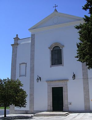
The Church-Shrine of Our Lady of Light (Portuguese: Igreja-Santuário de Nossa Senhora da Luz) is a Marian shrine and Catholic church in freguesia Carnide of Lisbon, Portugal. It is classified as a National Monument.
Telheiras Station
Metro station in Lisbon, Portugal
Distance: Approx. 1563 meters
Latitude and longitude: 38.76027778,-9.16611111
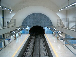
Telheiras station is the northern terminus on the Green Line of the Lisbon Metro. The station is located between Rua Prof. Francisco Gentil and Estrada de Telheiras, next to Azinhaga do Areeiro.

Colombo Centre
Shopping mall in Lisbon, Portugal
Distance: Approx. 1454 meters
Latitude and longitude: 38.75444444,-9.18833333
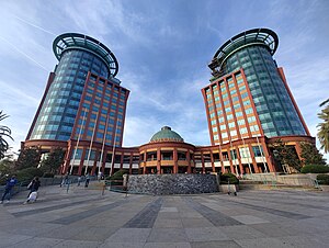
The Colombo Centre (Centro Colombo in Portuguese) is a shopping mall located in the parish of Carnide in Lisbon and attracts many visitors. It is situated next to the Lusíada avenue and the Segunda Circular; there is a bus terminal next to the building and the Lisbon Metro station Colégio Militar/Luz allows visitors easy access to Colombo.
Pontinha Station
Lisbon metro station
Distance: Approx. 1371 meters
Latitude and longitude: 38.76166667,-9.19666667
Pontinha station is part of the Blue Line of the Lisbon Metro and is located in the Bairro Mário Madeira neighbourhood of Lisbon, near the border with Amadora and Odivelas.
Carnide Station
Station on the Lisbon Metro
Distance: Approx. 1279 meters
Latitude and longitude: 38.75861111,-9.19277778
Carnide station is part of the Blue Line of the Lisbon Metro and is located near the Bairro da Horta Nova neighbourhood of Lisbon.
Weather in this IP's area
clear sky
15 Celsius
15 Celsius
14 Celsius
16 Celsius
1019 hPa
81 %
1019 hPa
1007 hPa
10000 meters
3.09 m/s
310 degree
07:22:53
17:21:22


