Country:
 Portugal
Region:
City:
Latitude and Longitude:
Time Zone:
Postal Code:
IP information under different IP Channel
ip-api
Country
Region
City
ASN
Time Zone
ISP
Blacklist
Proxy
Latitude
Longitude
Postal
Route
IPinfo
Country
Region
City
ASN
Time Zone
ISP
Blacklist
Proxy
Latitude
Longitude
Postal
Route
MaxMind
Country
Region
City
ASN
Time Zone
ISP
Blacklist
Proxy
Latitude
Longitude
Postal
Route
Luminati
Country
PTRegion
11
City
porto
ASN
Time Zone
Europe/Lisbon
ISP
Nos Comunicacoes, S.A.
Latitude
Longitude
Postal
db-ip
Country
Region
City
ASN
Time Zone
ISP
Blacklist
Proxy
Latitude
Longitude
Postal
Route
ipdata
Country
Region
City
ASN
Time Zone
ISP
Blacklist
Proxy
Latitude
Longitude
Postal
Route
Popular places and events near this IP address
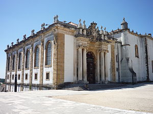
Biblioteca Joanina
Building
Distance: Approx. 1419 meters
Latitude and longitude: 40.2071,-8.4265
The Biblioteca Joanina, sometimes known in English as the Joanine Library, is a Baroque library in Coimbra, Portugal, located at the heart of the University of Coimbra. The Biblioteca Joanina is regularly considered one of the most beautiful libraries in the world. The Biblioteca Joanina is named after its founder, King John V of Portugal, who began construction on the library in 1717, during the onset of the Age of Enlightenment in Europe.

Quinta das Lágrimas
Distance: Approx. 614 meters
Latitude and longitude: 40.19805556,-8.43333333
Quinta das Lágrimas (Portuguese pronunciation: [ˈkĩtɐ ðɐʒ ˈlaɣɾimɐʃ]) is a quinta in Coimbra. It was classified in 1977 as an "Imóvel de Interesse Publico" (En: Building of Public Interest) by the IPPAR. It includes 12 ha (29.6 acres) of gardens and a palace that has been converted into a luxury hotel.
Coimbra University Stadium
Sports complex in Coimbra, Portugal
Distance: Approx. 829 meters
Latitude and longitude: 40.20598,-8.43475
The Coimbra University Stadium (Portuguese: Estádio Universitário de Coimbra), or EUC, is an extensive sports complex of the University of Coimbra on Mondego's left bank, in Santa Clara parish, in the city of Coimbra, Portugal. The stadium was opened in 1963. It has 2 football (soccer) fields, one of them with an athletics track, a rugby union field, gymnasiums, tennis courts, a Radio-Controlled car track, and two multisports pavilions for play indoor sports such as basketball, handball, rink hockey, and volleyball.

Portugal dos Pequenitos
Miniature park in Coimbra, Portugal
Distance: Approx. 627 meters
Latitude and longitude: 40.20305556,-8.43416667
The Portugal dos Pequenitos (translated as Portugal of/for the Little Ones) is a miniature park in the civil parish of Santa Clara e Castelo Viegas, in the municipality of Coimbra, in the Portuguese district of Coimbra. The park consists of diminutive versions of Portuguese houses and monuments, and has pavilions dedicated to the former Portuguese colonies.

Monastery of Santa Clara-a-Velha
Distance: Approx. 661 meters
Latitude and longitude: 40.20275556,-8.43343889
The ruins of the Monastery of Santa Clara-a-Velha (Old St. Clare) are located in the city of Coimbra, in Portugal. The monastery was built in the 14th century on the left bank of the Mondego River, but had to be abandoned in the 17th century due to frequent floods.

Monastery of Santa Clara-a-Nova
Distance: Approx. 525 meters
Latitude and longitude: 40.2034,-8.4362
The Monastery of Santa Clara-a-Nova (Portuguese: Mosteiro de Santa Clara-a-Nova) is a monastery in Coimbra, Portugal. It was built to replace the mediaeval Monastery of Santa Clara-a-Velha, located nearby, which at the time was prone to frequent flooding by the waters of the Mondego river. The monastery was built in the 17th and 18th centuries and is classified as a National Monument.
Santa Clara (Coimbra)
Civil parish in Centro, Portugal
Distance: Approx. 1010 meters
Latitude and longitude: 40.19083333,-8.43833333
Santa Clara is a former civil parish in the municipality of Coimbra, Portugal. It was also known as São Francisco or São Francisco da Ponte after its foundation in 1855. The population in 2011 was 9,929, in an area of 9.77 km2.

Pedro e Inês bridge
Footbridge in Coimbra, Portugal
Distance: Approx. 1111 meters
Latitude and longitude: 40.20111111,-8.42722222
The Pedro e Inês bridge is a footbridge opened in 2007 in the town of Coimbra in Portugal. It was designed by Cecil Balmond, Arup Group, and Portuguese civil engineer António Adão da Fonseca. Spanning the Rio Mondego, the 600 feet (180 m) structure is the city's first footbridge and has become locally known as the "bridge that doesn't meet." Partly inspired by skipping stones, the design is created from two cantilevered walkways joining in the middle.

Igreja de Santiago (Coimbra)
Distance: Approx. 1407 meters
Latitude and longitude: 40.2094718,-8.4295292
Igreja de Santiago (São Tiago Church) is a church located at Praça do Comércio in São Bartolomeu parish, Coimbra, Portugal. Built between the late 12th and early 13th centuries, it is one of the great Romanesque monuments of the city, and is classified as a National Monument. First construction began before 957, as evidenced by a document donated to Lorraine Monastery.
Santa Clara e Castelo Viegas
Civil parish in Centro, Portugal
Distance: Approx. 27 meters
Latitude and longitude: 40.2,-8.44
Santa Clara e Castelo Viegas is a civil parish in the municipality of Coimbra, Portugal. It was formed in 2013 by the merger of the former parishes Santa Clara and Castelo Viegas. The population in 2011 was 11,624, in an area of 17.63 km².
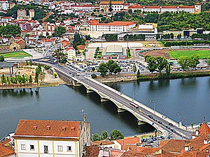
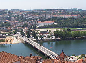
Ponte de Santa Clara
Bridge in Portugal
Distance: Approx. 1079 meters
Latitude and longitude: 40.20611111,-8.43055556
The Ponte de Santa Clara (Portuguese for Santa Clara Bridge) is a t-section and haunched girder bridge completed and opened on 30 October 1954, crossing the Mondego River leading to the town square of Coimbra. It was inaugurated on the same date it opened by prime minister António de Oliveira Salazar for a total cost of 15,000 contos (€ 75,000).
São Bartolomeu (Coimbra)
Civil parish in Centro, Portugal
Distance: Approx. 1255 meters
Latitude and longitude: 40.21,-8.43388889
São Bartolomeu is a former civil parish in the municipality of Coimbra, Portugal. The population in 2011 was 627 in an area of 0.17 km2, meaning it's the least populated bairro in Coimbra. On 28 January 2013 it merged with Sé Nova, Santa Cruz, and Almedina to form Coimbra (Sé Nova, Santa Cruz, Almedina e São Bartolomeu).
Weather in this IP's area
overcast clouds
17 Celsius
17 Celsius
17 Celsius
17 Celsius
1019 hPa
98 %
1019 hPa
1006 hPa
10000 meters
0.58 m/s
0.9 m/s
50 degree
100 %
07:30:15
19:16:13