Country:
 Portugal
Region:
City:
Latitude and Longitude:
Time Zone:
Postal Code:
IP information under different IP Channel
ip-api
Country
Region
City
ASN
Time Zone
ISP
Blacklist
Proxy
Latitude
Longitude
Postal
Route
IPinfo
Country
Region
City
ASN
Time Zone
ISP
Blacklist
Proxy
Latitude
Longitude
Postal
Route
MaxMind
Country
Region
City
ASN
Time Zone
ISP
Blacklist
Proxy
Latitude
Longitude
Postal
Route
Luminati
Country
PTRegion
01
City
espinho
ASN
Time Zone
Europe/Lisbon
ISP
Nos Comunicacoes, S.A.
Latitude
Longitude
Postal
db-ip
Country
Region
City
ASN
Time Zone
ISP
Blacklist
Proxy
Latitude
Longitude
Postal
Route
ipdata
Country
Region
City
ASN
Time Zone
ISP
Blacklist
Proxy
Latitude
Longitude
Postal
Route
Popular places and events near this IP address

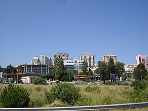
Amadora
Municipality in Lisbon, Portugal
Distance: Approx. 1581 meters
Latitude and longitude: 38.73333333,-9.23333333
Amadora (European Portuguese pronunciation: [ɐmɐˈðoɾɐ] ) is a city and municipality in the northwest of the Lisbon metropolitan area and 10 km from central Lisbon. The population in 2011 was 175,136, in an area of 23.78 km2 (9.2 sq mi). It is the fourth biggest, and most densely populated, city in Portugal.
Estádio José Gomes
Football stadium in Amadora, Portugal
Distance: Approx. 783 meters
Latitude and longitude: 38.75194444,-9.22805556
Estádio José Gomes, informally known as Estádio da Reboleira, after its location, is the stadium of the Portuguese football team C.F. Estrela da Amadora and it has a capacity of 9,288.
Alfragide
Civil parish in Lisbon, Portugal
Distance: Approx. 1398 meters
Latitude and longitude: 38.734,-9.218
Alfragide (Portuguese pronunciation: [alfɾɐˈʒiðɨ]) is a parish in Amadora Municipality. The population in 2011 was 17,044, in an area of 2.51 km². Its patron saint is Our Lady of Fatima.
Buraca
Distance: Approx. 1332 meters
Latitude and longitude: 38.74222222,-9.20944444
Buraca (Portuguese pronunciation: [buˈɾakɐ]) is a former civil parish, located in the municipality of Amadora, Portugal. In 2013, the parish merged into the new parish of Águas Livres. As of the 2011 Census, it had a population of 15 892.
Sorefame
Portuguese railway rolling stock and industrial equipment manufacturer
Distance: Approx. 867 meters
Latitude and longitude: 38.75332,-9.22281
Sorefame (an abbreviation of Sociedades Reunidas de Fabricações Metálicas, meaning "Reunited Society of Metalwork Fabrications") was a Portuguese manufacturer of railway rolling stock and industrial equipment, such as dam gates equipment. Established in 1943, the company was in the 1990s split into a rolling stock company, Nova Sorefame, and a dam equipment company, Hidrosorefame. Nova Sorefame became part of ABB's rail transport division, later Adtranz, and in 2001 part of Bombardier transportation and was closed in 2005.
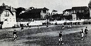
Campo da Feiteira
Distance: Approx. 1756 meters
Latitude and longitude: 38.751778,-9.205551
Campo da Feiteira was a football dirt field in Lisbon, Portugal. It started as field for Grupo Sport de Benfica to organize Sports Festivals. On 26 May 1907, Grupo Sport de Benfica officially taken over of Quinta da Feiteira, next to Estrada de Benfica, having from now on, a 120 meters per 79 metres field, for $20 a semester.
C.F. Benfica
Portuguese sports club
Distance: Approx. 1540 meters
Latitude and longitude: 38.74920833,-9.20704167
Clube Futebol Benfica (Portuguese pronunciation: [bɐ̃jˈfikɐ]), commonly known as Futebol Benfica, or simply as Fofó (Portuguese pronunciation: [fɔˈfɔ]), is a Portuguese sports club based in the Benfica neighborhood of Lisbon. The club was founded on 23 March 1933; however, the origins of the club can be traced back to 1895. Futebol Benfica is mostly known for its men's football, women's football, field hockey and roller hockey teams.

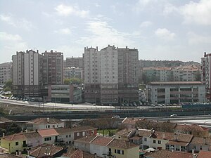
Alfragide Towers
Buildings in Alfragide, Portugal
Distance: Approx. 1491 meters
Latitude and longitude: 38.733103,-9.217975
The Alfragide Towers (Portuguese: Torres de Alfragide) are a set of residential buildings in Alfragide, Amadora, Portugal. The complex consists of three residential towers and a shopping centre at ground level, connecting the three buildings. It also contains an underground car park and a complex of swimming pools, currently unused.

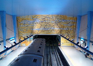
Reboleira Station (Lisbon Metro)
Metro station in Amadora, Portugal
Distance: Approx. 739 meters
Latitude and longitude: 38.75222222,-9.22472222
Reboleira station is the northern terminus on the Blue Line of the Lisbon Metro.
Amadora Este Station
Metro station in Amadora, Portugal
Distance: Approx. 1456 meters
Latitude and longitude: 38.75777778,-9.21805556
Amadora Este station is part of the Blue Line of the Lisbon Metro and is located on the east side of Amadora.
Águas Livres (Amadora)
Civil parish in Lisbon, Portugal
Distance: Approx. 795 meters
Latitude and longitude: 38.744622,-9.215091
Águas Livres is a Portuguese urban civil parish (freguesia) in the municipality of Amadora. The population in 2011 was 37,426. It was created in 2011, incorporating most of the area from the former parishes of Buraca, Damaia, and Reboleira.

Amadora railway station
Railway station in Amadora, Portugal
Distance: Approx. 1895 meters
Latitude and longitude: 38.75986944,-9.23605278
Amadora Station (Portuguese: Estação Ferroviária da Amadora) is a railway station located in the city of Amadora. It is served by the Sintra and Azambuja Lines. It is managed by Infraestruturas de Portugal.
Weather in this IP's area
light rain
18 Celsius
18 Celsius
17 Celsius
19 Celsius
1018 hPa
84 %
1018 hPa
1001 hPa
10000 meters
2.06 m/s
340 degree
20 %
07:32:54
19:19:50