Country:
 Portugal
Region:
City:
Latitude and Longitude:
Time Zone:
Postal Code:
IP information under different IP Channel
ip-api
Country
Region
City
ASN
Time Zone
ISP
Blacklist
Proxy
Latitude
Longitude
Postal
Route
IPinfo
Country
Region
City
ASN
Time Zone
ISP
Blacklist
Proxy
Latitude
Longitude
Postal
Route
MaxMind
Country
Region
City
ASN
Time Zone
ISP
Blacklist
Proxy
Latitude
Longitude
Postal
Route
Luminati
Country
PTRegion
01
City
espinho
ASN
Time Zone
Europe/Lisbon
ISP
Nos Comunicacoes, S.A.
Latitude
Longitude
Postal
db-ip
Country
Region
City
ASN
Time Zone
ISP
Blacklist
Proxy
Latitude
Longitude
Postal
Route
ipdata
Country
Region
City
ASN
Time Zone
ISP
Blacklist
Proxy
Latitude
Longitude
Postal
Route
Popular places and events near this IP address
Battle of Alfarrobeira
1449 battle between Portuguese royal forces and those of the rebellious Duke of Coimbra
Distance: Approx. 3449 meters
Latitude and longitude: 38.87107,-9.07793
The Battle of Alfarrobeira (Portuguese pronunciation: [alfɐʁuˈβɐjɾɐ]) took place on 20 May 1449. It was a confrontation between the forces commanded by King Afonso V of Portugal and his uncle Afonso, Duke of Braganza, against the army of the rebellious Peter, Duke of Coimbra. The place was Vialonga, near Lisbon, at the margins of the creek of Alfarrobeira.
Sacavém
Civil parish in Lisbon, Portugal
Distance: Approx. 5499 meters
Latitude and longitude: 38.79444444,-9.10527778
Sacavém (Portuguese pronunciation: [sɐkɐˈvɐ̃j]; Arabic: شقبان) is a city and former civil parish in the municipality of Loures, Lisbon District, Portugal. In 2013, the parish merged into the new parish Sacavém e Prior Velho. It is a few kilometers north-east of the Portuguese capital, Lisbon.
Póvoa de Santa Iria e Forte da Casa
Civil parish in Vila Franca de Xira, Portugal
Distance: Approx. 2880 meters
Latitude and longitude: 38.86,-9.06
Póvoa de Santa Iria e Forte da Casa is a civil parish in the municipality of Vila Franca de Xira, Portugal. It was formed in 2013 by the merger of the former parishes Póvoa de Santa Iria and Forte da Casa. The population in 2021 was 40,905, in an area of 9.16 km².
Forte da Casa
Town in Vila Franca de Xira, Portugal
Distance: Approx. 4079 meters
Latitude and longitude: 38.872,-9.058
Forte da Casa is a town and former civil parish in the municipality of Vila Franca de Xira, Portugal. Since 2013, it is part of the civil parish Póvoa de Santa Iria e Forte da Casa. Its population in 2011 was 11,056 in an area of 3.96 km2.
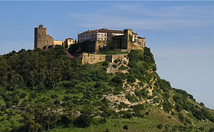
Castelo de Pirescoxe
Castle in Portugal
Distance: Approx. 960 meters
Latitude and longitude: 38.8370842,-9.0917047
Castelo de Pirescoxe is a castle in Portugal. It is part of Loures, Grande Lisboa Subregion. It is classified by IGESPAR as a site of public interest.

Póvoa de Santa Iria
City in Vila Franca de Xira, Portugal
Distance: Approx. 2654 meters
Latitude and longitude: 38.862,-9.069
Póvoa de Santa Iria is a city and former civil parish in the municipality of Vila Franca de Xira, Portugal. Since 2013, it is part of the civil parish Póvoa de Santa Iria e Forte da Casa. Its population in 2011 was 29,348.
Fort of Casa
19th-century fort in Portugal
Distance: Approx. 4373 meters
Latitude and longitude: 38.87444444,-9.05666667
The Fort of Casa was the most easterly of the forts and redoubts built in 1809-10 during the Peninsular War on the second line of the three defensive Lines of Torres Vedras aimed at protecting the capital of Portugal, Lisbon. It is situated in the town of Forte da Casa, in the municipality of Vila Franca de Xira, in the Lisbon District.
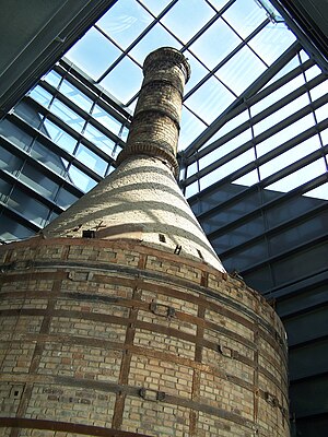
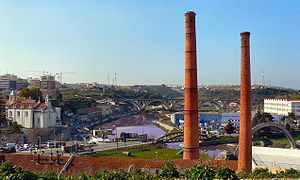
Ceramics Museum of Sacavém
Museum near Lisbon, Portugal
Distance: Approx. 5438 meters
Latitude and longitude: 38.794187,-9.102438
The Ceramics Museum of Sacavém (Portuguese: Museu de Cerâmica de Sacavém) is situated in the town of Sacavém in the municipality of Loures, just northeast of Lisbon in Portugal. The museum was opened in July 2000 and was constructed on the grounds of a former ceramics factory. Most of the exhibits reflect the output of that factory and its documentation centre is devoted to the study of the history and production of the factory and the industrial heritage of the municipality.
Fort of Sacavém
19th-century fort in Portugal
Distance: Approx. 5238 meters
Latitude and longitude: 38.795833,-9.1015
The Redoubt of Mount Cintra (or Mount Sintra), commonly known as the Fort of Sacavém, is located in the town of Sacavém in the municipality of Loures in the Lisbon District of Portugal. It is situated immediately to the north of Lisbon. The fort’s construction began in 1875 and was completed in 1892.
Trancão River
River in Portugal
Distance: Approx. 4965 meters
Latitude and longitude: 38.79611111,-9.09
The Trancão River (Portuguese pronunciation: [tɾɐ̃ˈkɐ̃w]), formerly called Rio de Sacavém, is a small river in Portugal (about 29 km) from District of Lisbon. Near its mouth, this watercourse can also be called Ribeira de Sacavém ou Vala de Sacavém.

Vialonga, Portugal
Town and civil parish in Vila Franca de Xira, Portugal
Distance: Approx. 3763 meters
Latitude and longitude: 38.874,-9.082
Vialonga is a town and civil parish in the municipality of Vila Franca de Xira, Portugal. Its population in 2021 was 21,261.
Póvoa de Santa Iria train collision
1986 railway accident in Póvoa de Santa Iria, Portugal
Distance: Approx. 2595 meters
Latitude and longitude: 38.85928486,-9.06419576
The Póvoa de Santa Iria train collision was a rail transport accident that occurred in the train station of Póvoa de Santa Iria, Portugal, on 5 May 1986. It caused the death of 17 people and left 83 others injured. It is considered one of the worst rail accidents that ever happened in Portugal.
Weather in this IP's area
light rain
19 Celsius
19 Celsius
17 Celsius
20 Celsius
1018 hPa
85 %
1018 hPa
1015 hPa
10000 meters
2.57 m/s
340 degree
75 %
07:32:22
19:19:13