Country:
 Portugal
Region:
City:
Latitude and Longitude:
Time Zone:
Postal Code:
IP information under different IP Channel
ip-api
Country
Region
City
ASN
Time Zone
ISP
Blacklist
Proxy
Latitude
Longitude
Postal
Route
Luminati
Country
PTRegion
07
City
evora
ASN
Time Zone
Europe/Lisbon
ISP
Nos Comunicacoes, S.A.
Latitude
Longitude
Postal
IPinfo
Country
Region
City
ASN
Time Zone
ISP
Blacklist
Proxy
Latitude
Longitude
Postal
Route
db-ip
Country
Region
City
ASN
Time Zone
ISP
Blacklist
Proxy
Latitude
Longitude
Postal
Route
ipdata
Country
Region
City
ASN
Time Zone
ISP
Blacklist
Proxy
Latitude
Longitude
Postal
Route
Popular places and events near this IP address

Chaves, Portugal
Municipality in Norte, Portugal
Distance: Approx. 2190 meters
Latitude and longitude: 41.74055556,-7.47138889
Chaves (Portuguese pronunciation: [ˈʃavɨʃ] ) is a city and a municipality in the north of Portugal. It is 10 km south of the Spanish border and 22 km south of Verín (Spain). The population of the entire municipality in 2011 was 41,243, in an area of 591.23 km2.

Roman Bridge of Chaves
Bridge in the river tamega in Chaves city, Portugal
Distance: Approx. 2429 meters
Latitude and longitude: 41.7383,-7.4672
Trajan's Bridge (Portuguese: Ponte de Trajano) is a Roman bridge in the civil parish of Santa Maria Maior, in the municipality of Chaves in the Portuguese northern subregion of Terras de Trás-os-Montes.

Aquae Flaviae
Human settlement in Portugal
Distance: Approx. 2349 meters
Latitude and longitude: 41.739,-7.469
Aquae Flaviae (or Aquæ Flaviæ) is the ancient Roman city and former bishopric (now a Latin Catholic titular see) of Chaves, a municipality in the Portuguese district of Vila Real.
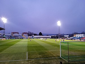
Estádio Municipal Eng. Manuel Branco Teixeira
Stadium in Chaves, Portugal
Distance: Approx. 1094 meters
Latitude and longitude: 41.7506,-7.46499
Estádio Municipal Eng. Manuel Branco Teixeira is a multi-use stadium in Chaves, Portugal. It is currently used mostly for football matches and is the home stadium of GD Chaves.
Sanjurge
Civil parish in Norte, Portugal
Distance: Approx. 3472 meters
Latitude and longitude: 41.77583333,-7.50444444
Sanjurge is a small rural village and former-civil parish in the municipality of Chaves, in the Portuguese district of Vila Real. In 2013, the parish located 6 kilometres (3.7 mi) from the centre of Chaves, was merged into the new parish of Santa Cruz-Trindade e Sanjurge, as part of the White Paper on local authority reform.

Castle of Chaves
Castle in Chaves, Portugal
Distance: Approx. 2299 meters
Latitude and longitude: 41.73961111,-7.47183333
Castle of Chaves (Portuguese: Castelo de Chaves) is a medieval castle situated in the civil parish of Santa Maria Maior, in the municipality of Chaves, district of Vila Real. It is classified as a National Monument.
Chaves Airfield
Airport
Distance: Approx. 4233 meters
Latitude and longitude: 41.72222222,-7.46388889
Chaves Airfield (IATA: CHV, ICAO: LPCH) is a recreational aerodrome serving Chaves in northern Portugal. There is no commercial air transport.
Santa Cruz-Trindade e Sanjurge
Civil parish in Norte, Portugal
Distance: Approx. 271 meters
Latitude and longitude: 41.758,-7.47
Santa Cruz-Trindade e Sanjurge is a civil parish in the municipality of Chaves, Portugal. It was formed in 2013 by the merger of the former parishes Santa Cruz-Trindade and Sanjurge. The population in 2011 was 3,430, in an area of 13.38 km2.

Castle of Santo Estêvão
Medieval castle in Vila Real, Portugal
Distance: Approx. 4202 meters
Latitude and longitude: 41.75944444,-7.41775
The Castle of Santo Estêvão (Portuguese: Castelo de Santo Estêvão) is a medieval castle located in the civil parish of Santo Estêvão, municipality of Chaves, in the Portuguese district of Vila Real. Located in a dominant position over the village, the castle is within walking distance of the course of the river Tamega and the border with Spain.
Aquae Flaviae (titular see)
Distance: Approx. 2349 meters
Latitude and longitude: 41.739,-7.469
The Titular See of Aqua Flaviae (Portuguese: Sé titular de Aqua Flaviae/Diocese de Aquæ Flaviæ) is a former diocese in the Portuguese district of Vial Real and current titular seat of Chaves.

Fort São Neutel
Distance: Approx. 1119 meters
Latitude and longitude: 41.75006187,-7.46767482
Fort São Neutel is located in the Parish of Santa Maria Maior of the city of Chaves, District of Vila Real, in Portugal. It complemented the defence provided by Fort São Francisco to the city of Chaves, on the hill to the north, by the border with Galicia. The São Neutel Fort has been classified as a National Monument since 1938.

Fort São Francisco of Chaves
Distance: Approx. 1899 meters
Latitude and longitude: 41.74305556,-7.46916667
The Fort Nossa Senhora do Rosário, better known as Forte São Francisco of Chaves is located in the city of Chaves, in the Parish of Santa Maria Maior, District of Vila Real, in Portugal. Together with Fort São Neutel, this fort, in a dominant position on the Pedisqueira hill, next to the Tâmega river and the old Roman bridge, was intended to defend Chaves, on the Galician border, at the time of the Restoration War. The São Francisco Fort has been classified as a National Monument since 1938.
Weather in this IP's area
overcast clouds
15 Celsius
15 Celsius
15 Celsius
15 Celsius
1024 hPa
95 %
1024 hPa
978 hPa
10000 meters
1.01 m/s
1 m/s
115 degree
100 %
07:07:17
17:19:39