Country:
Region:
City:
Latitude and Longitude:
Time Zone:
Postal Code:
IP information under different IP Channel
ip-api
Country
Region
City
ASN
Time Zone
ISP
Blacklist
Proxy
Latitude
Longitude
Postal
Route
Luminati
Country
Region
07
City
evora
ASN
Time Zone
Europe/Lisbon
ISP
Nos Comunicacoes, S.A.
Latitude
Longitude
Postal
IPinfo
Country
Region
City
ASN
Time Zone
ISP
Blacklist
Proxy
Latitude
Longitude
Postal
Route
db-ip
Country
Region
City
ASN
Time Zone
ISP
Blacklist
Proxy
Latitude
Longitude
Postal
Route
ipdata
Country
Region
City
ASN
Time Zone
ISP
Blacklist
Proxy
Latitude
Longitude
Postal
Route
Popular places and events near this IP address

Grande Porto
Distance: Approx. 977 meters
Latitude and longitude: 41.15,-8.6333
Grande Porto (Portuguese pronunciation: [ˈɡɾɐ̃dɨ ˈpoɾtu]) or Greater Porto is a former Portuguese NUTS3 subregion, integrating the NUTS2 region of Norte, in Portugal. It was abolished at the January 2015 NUTS 3 revision. It corresponded to 11 municipalities out of 16, the other 5 in Entre Douro e Vouga Subregion that constitute the larger Greater Metropolitan Area of Porto, centered in the city of Porto.

Super Bock Arena
Distance: Approx. 1233 meters
Latitude and longitude: 41.14687778,-8.62598889
The Super Bock Arena (Pavilhão Rosa Mota) is a cultural and sports arena in Porto, Portugal.

São Pedro da Afurada
Former civil parish in Vila Nova de Gaia, Portugal
Distance: Approx. 602 meters
Latitude and longitude: 41.145,-8.646
São Pedro da Afurada (or simply Afurada) is a former civil parish in the municipality of Vila Nova de Gaia, Portugal. In 2013, the parish merged into the new parish Santa Marinha e São Pedro da Afurada. The population in 2011 was 3,568, in an area of 1.00 km².

Santa Marinha (Vila Nova de Gaia)
Distance: Approx. 314 meters
Latitude and longitude: 41.14,-8.641
Santa Marinha is a former civil parish in the municipality of Vila Nova de Gaia, Portugal. In 2013, the parish merged into the new parish Santa Marinha e São Pedro da Afurada. The population in 2011 was 30,146, in an area of 6.91 km².
Almeida Garrett Library
Library in Portugal
Distance: Approx. 1220 meters
Latitude and longitude: 41.14805556,-8.62694444
Almeida Garrett Library (Portuguese: Biblioteca Almeida Garrett) is a library located in the civil parish of Lordelo do Ouro e Massarelos, in municipality of Porto, Portugal.
Centre for Astrophysics of the University of Porto
Distance: Approx. 898 meters
Latitude and longitude: 41.15063611,-8.63866111
The Centro de Astrofísica da Universidade do Porto (Centre for Astrophysics of the University of Porto - CAUP) is a private, non-profit scientific association, recognized as being of public utility by the Portuguese Government. It was created in May of 1989 by the Universidade do Porto. Its objectives include the promotion and support of astronomy through research education at graduate and undergraduate levels activities for primary and secondary schools science outreach and the popularisation of astronomy CAUP is responsible for the scientific management of the Porto Planetarium.

Porto School of Architecture
Architecture school of the University of Porto
Distance: Approx. 902 meters
Latitude and longitude: 41.15027778,-8.63611111
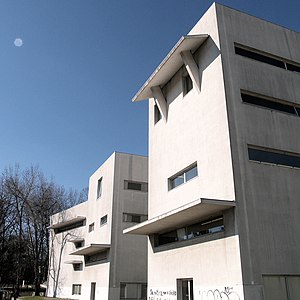
The Faculty of Architecture of the University of Porto (Portuguese: Faculdade de Arquitectura da Universidade do Porto), or FAUP, is an architecture faculty located in Porto, Portugal, and one of the fourteen constituent faculties of the University of Porto.

Casa Tait
Residence in Lordelo do Ouro e Massarelos, Portugal
Distance: Approx. 1084 meters
Latitude and longitude: 41.14777778,-8.62861111
The Tait House (Portuguese: Casa Tait) is a former 18th century residence in the civil parish of Lordelo do Ouro e Massarelos, in the municipality of Porto, in northern Portugal. Today it is a Museum of Numismatics.
Port Wine Museum
Distance: Approx. 1111 meters
Latitude and longitude: 41.145,-8.6267
The Port Wine Museum (Museu do Vinho do Porto) is a museum located in Porto, Portugal. The museum recounts the history of port wine and its relevance to the city and the country. The museum is located in an 18th-century warehouse, the Companhia Geral da Agricultura das Vinhas do Alto Douro, next to Douro River.
Porto Tram Museum
Tram museum in Portugal
Distance: Approx. 800 meters
Latitude and longitude: 41.147706,-8.632836
The Porto Tram Museum (Museu do Carro Eléctrico) is a museum operated by the Sociedade de Transportes Colectivos do Porto. It was inaugurated in 1992 and is installed in a former thermoelectric power station next to the River Douro in Massarelos, Porto, Portugal. It exhibits material related to the history of trams in Porto.
Holocaust Museum of Oporto
Distance: Approx. 1166 meters
Latitude and longitude: 41.15298,-8.63772
The Holocaust Museum of Oporto (Portuguese: Museu de Holocausto do Porto) is a Holocaust museum founded in 2021. The main themes treated at the new Museum are Jewish life before the Holocaust, Nazism, Nazi expansion in Europe, the ghettoes, refugees, concentration, labour and extermination camps, the Final Solution, the death marches, liberation, the postwar Jewish population, the foundation of the State of Israel, win or starve, the Righteous Among the Nations. Visitors to the Museum will see a reproduction of the dorms of Auschwitz, a names room, a flame memorial, cinema, conference room, study centre, corridors with the complete narrative and, in the image of the Holocaust Washington Museum, photographs and screens showing films about the before, during and after the tragedy.

Agramonte Cemetery
Cemetery in Porto, Portugal
Distance: Approx. 1073 meters
Latitude and longitude: 41.15055556,-8.63233333
The Agramonte Cemetery is a cemetery in the city of Porto, in Portugal which dates back to 1855.
Weather in this IP's area
scattered clouds
18 Celsius
18 Celsius
18 Celsius
18 Celsius
1022 hPa
94 %
1022 hPa
1015 hPa
10000 meters
4.12 m/s
160 degree
40 %
07:10:44
17:25:34


