Country:
Region:
City:
Latitude and Longitude:
Time Zone:
Postal Code:
IP information under different IP Channel
ip-api
Country
Region
City
ASN
Time Zone
ISP
Blacklist
Proxy
Latitude
Longitude
Postal
Route
Luminati
Country
Region
e
City
norrkoping
ASN
Time Zone
Europe/Stockholm
ISP
Obenetwork AB
Latitude
Longitude
Postal
IPinfo
Country
Region
City
ASN
Time Zone
ISP
Blacklist
Proxy
Latitude
Longitude
Postal
Route
db-ip
Country
Region
City
ASN
Time Zone
ISP
Blacklist
Proxy
Latitude
Longitude
Postal
Route
ipdata
Country
Region
City
ASN
Time Zone
ISP
Blacklist
Proxy
Latitude
Longitude
Postal
Route
Popular places and events near this IP address
Bredäng
District of Söderort, Stockholm, Sweden
Distance: Approx. 1772 meters
Latitude and longitude: 59.29472222,17.9325
Bredäng is a district of Söderort, Stockholm, Sweden. In the southwest section of the city, it is a part of the Skärholmen borough and is named after a former farm in the area. Bredäng has an 18th-century mansion (Jakobsbergs gård) named after its first owner, Jacob Graver.
Fruängen
Distance: Approx. 367 meters
Latitude and longitude: 59.28583333,17.965
Fruängen (literally: Wife Meadow or Lady Meadow) is a district in Stockholm, Sweden. It is part of the Hägersten-Liljeholmen borough in Söderort, the southern suburban area of Stockholm. It was built in the early 1950s.

Västertorp
Distance: Approx. 426 meters
Latitude and longitude: 59.29111111,17.96666667
Västertorp (Westcroft) is a district of the Hägersten-Liljeholmen borough in Söderort, the southern suburban part of Stockholm, Sweden.

Mälarhöjden
Urban district in southwest Stockholm, Sweden
Distance: Approx. 1422 meters
Latitude and longitude: 59.30111111,17.95722222
Mälarhöjden is a suburb in south-west Stockholm, Sweden. It is a part of Hägersten borough. The area is dominated by single-family houses.

Hägerstensåsen
Distance: Approx. 1276 meters
Latitude and longitude: 59.29555556,17.97888889
Hägerstensåsen is a district of the Hägersten-Liljeholmen borough in Söderort, the southern suburban part of Stockholm. It is located 7 km southwest of the capital and has a population of approximately 7,800 inhabitants.

Västertorp metro station
Stockholm Metro station
Distance: Approx. 426 meters
Latitude and longitude: 59.29111111,17.96666667
Västertorp is a Stockholm metro station located in the Västertorp suburb of Stockholm, Sweden. The station was opened on 5 April 1964 as part of the first stretch of the Red line, between T-Centralen and Fruängen. It is part of Line 14.

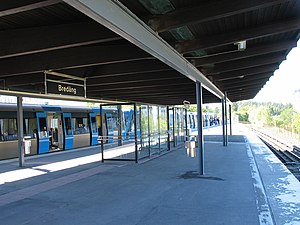
Bredäng metro station
Stockholm Metro station
Distance: Approx. 1713 meters
Latitude and longitude: 59.295,17.93388889
Bredäng metro station is a station on the red line of the Stockholm metro, located in the district of Bredäng. The station was opened on 16 May 1965 as part of the extension from Örnsberg to Sätra. The distance to Slussen is 9 km (5.6 mi).

Mälarhöjden metro station
Stockholm Metro station
Distance: Approx. 1421 meters
Latitude and longitude: 59.30096,17.95578
Mälarhöjden metro station is a station on the red line of the Stockholm metro, located in the district of Mälarhöjden. The station was opened on 16 May 1965 as part of the extension from Örnsberg to Sätra. It is 7.5 km (4.7 mi) from the Slussen metro station.

Fruängen metro station
Stockholm Metro station
Distance: Approx. 367 meters
Latitude and longitude: 59.28583333,17.965
Fruängen metro station is the end station on line 14 of the Stockholm metro, located in the district of Fruängen. The station was opened on 5 April 1964 as the south terminus of the first stretch of the Red line, from T-Centralen. The distance to Slussen is 8.1 km (5.0 mi).

Hägerstensåsen metro station
Stockholm metro station
Distance: Approx. 1276 meters
Latitude and longitude: 59.29555556,17.97888889
Hägerstensåsen metro station is a station on Line 14 in the Stockholm metro, located in the district of Hägerstensåsen. The station was opened on 5 April 1964 as part of the first stretch of Metro 2, between T-Centralen and Fruängen.
Efter badet
Limestone sculpture in Stockholm, Sweden
Distance: Approx. 1065 meters
Latitude and longitude: 59.2933,17.9774
Efter badet (Swedish, 'After the Bath') is a public sculpture, cut in limestone and located in the Västertorp district of suburban Stockholm. It was designed by the sculptor Pye Engström, who spent five years between 1971 and 1976 working on it. Since 1976 it has been located outside of Västertorpshallen, a municipally owned public bath.

Långbro Hospital
Swedish psychiatric hospital (1909–1997)
Distance: Approx. 1195 meters
Latitude and longitude: 59.28027778,17.97472222
Långbro Hospital (Swedish: Långbro sjukhus), also called Långbro Asylum, was a psychiatric hospital in the Långbro neighborhood of Stockholm, Sweden. Långbro sjukhusmuseum, created by Heritage Stockholm, is a digital exhibit that preserves the history of the hospital. The grounds of the hospital are now preserved as a public park called Långbroparken.
Weather in this IP's area
clear sky
8 Celsius
7 Celsius
8 Celsius
9 Celsius
1034 hPa
84 %
1034 hPa
1028 hPa
10000 meters
2.06 m/s
210 degree
07:25:19
15:38:35


