Country:
 Great Britain
Region:
City:
Latitude and Longitude:
Time Zone:
Postal Code:
IP information under different IP Channel
ip-api
Country
Region
City
ASN
Time Zone
ISP
Blacklist
Proxy
Latitude
Longitude
Postal
Route
IPinfo
Country
Region
City
ASN
Time Zone
ISP
Blacklist
Proxy
Latitude
Longitude
Postal
Route
MaxMind
Country
Region
City
ASN
Time Zone
ISP
Blacklist
Proxy
Latitude
Longitude
Postal
Route
Luminati
Country
GBASN
Time Zone
Europe/London
ISP
CW Vodafone Group PLC
Latitude
Longitude
Postal
db-ip
Country
Region
City
ASN
Time Zone
ISP
Blacklist
Proxy
Latitude
Longitude
Postal
Route
ipdata
Country
Region
City
ASN
Time Zone
ISP
Blacklist
Proxy
Latitude
Longitude
Postal
Route
Popular places and events near this IP address
Shaw, Berkshire
Distance: Approx. 964 meters
Latitude and longitude: 51.409,-1.314
Shaw is a suburban village in Berkshire, England. It is located to the north of Newbury, near the village of Donnington. It is in the parish of Shaw-cum-Donnington.

Donnington, Berkshire
Village in Berkshire, England
Distance: Approx. 796 meters
Latitude and longitude: 51.418,-1.331
Donnington is a village in the civil parish of Shaw-cum-Donnington in West Berkshire, England. It is located north of the town of Newbury. It contains a ruined medieval castle and a Strawberry Hill Gothic mansion.
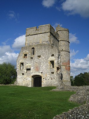
Donnington Castle
Ruined castle in Berkshire, England
Distance: Approx. 1270 meters
Latitude and longitude: 51.41944444,-1.3375
Donnington Castle is a ruined medieval castle, situated in the small village of Donnington, just north of the town of Newbury in the English county of Berkshire. It was founded by Sir Richard Abberbury the Elder in 1386 and was bought by Thomas Chaucer before the castle was taken under royal control during the Tudor period. During the First English Civil War the castle was held by the royalist Sir John Boys and withstood an 18-month siege; after the garrison eventually surrendered, Parliament voted to demolish Donnington Castle in 1646.

Second Battle of Newbury
1644 battle of the First English Civil War
Distance: Approx. 1112 meters
Latitude and longitude: 51.414,-1.335
The Second Battle of Newbury was a battle of the First English Civil War fought on 27 October 1644, in Speen, adjoining Newbury in Berkshire. The battle was fought close to the site of the First Battle of Newbury, which took place in late September the previous year. The combined armies of Parliament inflicted a tactical defeat on the Royalists, but failed to gain any strategic advantage.

Victoria Park, Newbury
Distance: Approx. 1550 meters
Latitude and longitude: 51.403,-1.321
Victoria Park is a small public park near to the centre of Newbury, Berkshire, England. Current features of the park include a bandstand, tennis courts, boating lake, bowls club, skatepark, and a statue of Queen Victoria.
Speenhamland, Berkshire
Distance: Approx. 1163 meters
Latitude and longitude: 51.407,-1.325
Speenhamland is an area within modern Newbury, Berkshire.

Shaw-cum-Donnington
Civil parish in England
Distance: Approx. 387 meters
Latitude and longitude: 51.415,-1.315
Shaw-cum-Donnington is a civil parish in West Berkshire, England with all of its urban or suburban area immediately north of the largest town in the district, Newbury. It comprises the villages of Shaw and Donnington and contains the partially ruined castle of Donnington Castle which has most of its various outside walls intact. The area is mostly green space but where developed is almost entirely residential with shops and cafés.

Shaw House, Berkshire
Distance: Approx. 548 meters
Latitude and longitude: 51.41222222,-1.31722222
Shaw House is an important example of an early symmetrical H-plan Elizabethan mansion, located at Shaw, on the north-eastern outskirts of Newbury in Berkshire.
Trinity School, Newbury
Academy in Shaw, Newbury, Berkshire
Distance: Approx. 435 meters
Latitude and longitude: 51.413,-1.32
Trinity School is a co-educational secondary school with academy status in Newbury, Berkshire, England. The school opened in September 1999 when two existing schools (Turnpike School and Shaw House School) and one new school combined - hence the name Trinity. Trinity School caters for pupils between the ages of 11 and 19 and currently has approximately 1025 students on roll, including 108 in the Sixth Form.
Parkway Newbury
Shopping mall in Berkshire, United Kingdom
Distance: Approx. 1449 meters
Latitude and longitude: 51.40409444,-1.32338333
Parkway Newbury is a retail and residential development in Newbury, Berkshire that opened on 27 October 2011. It includes 475,000 sq ft (44,000 m2) of retail and restaurant accommodation and Marks & Spencer, 578 shopper car parking spaces, 113 residents parking spaces. The mixed-use scheme also consists of 147 luxury residential apartments and 37 affordable housing units being built above the shopping centre.
Donnington Friary
1393–1538 friary in England
Distance: Approx. 831 meters
Latitude and longitude: 51.414588,-1.331057
Donnington Friary was a friary of crouched friars at Donnington in the English county of Berkshire. At the time of suppression the establishment was recorded as Trinitarian, but this was later corrected to Crossed Friars. This was possibly a ploy by the two brothers in occupation at the time in order to ensure their pension.

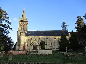
St Joseph's Church, Newbury
Church in Newbury, United Kingdom
Distance: Approx. 1164 meters
Latitude and longitude: 51.40647,-1.31843
St Joseph's Church is a parish of the Roman Catholic Church in Newbury, Berkshire, England, part of the Roman Catholic Diocese of Portsmouth. It is noted for its historic parish church, built from 1926 to 1928 in the Italianate style. It is located on the corner of London Road and Western Avenue north of the town centre.
Weather in this IP's area
overcast clouds
15 Celsius
15 Celsius
14 Celsius
16 Celsius
1003 hPa
97 %
1003 hPa
994 hPa
10000 meters
2.58 m/s
5.95 m/s
151 degree
95 %
06:29:46
19:36:19