Country:
Region:
City:
Latitude and Longitude:
Time Zone:
Postal Code:
IP information under different IP Channel
ip-api
Country
Region
City
ASN
Time Zone
ISP
Blacklist
Proxy
Latitude
Longitude
Postal
Route
Luminati
Country
ASN
Time Zone
Europe/Madrid
ISP
Entidad Publica Empresarial Red.es
Latitude
Longitude
Postal
IPinfo
Country
Region
City
ASN
Time Zone
ISP
Blacklist
Proxy
Latitude
Longitude
Postal
Route
db-ip
Country
Region
City
ASN
Time Zone
ISP
Blacklist
Proxy
Latitude
Longitude
Postal
Route
ipdata
Country
Region
City
ASN
Time Zone
ISP
Blacklist
Proxy
Latitude
Longitude
Postal
Route
Popular places and events near this IP address

Torre Picasso
Skyscraper in Madrid, Spain
Distance: Approx. 297 meters
Latitude and longitude: 40.45027778,-3.6925
Torre Picasso (Picasso Tower) is a skyscraper in Madrid, Spain designed by Minoru Yamasaki. From 1988 until 2007 it was the tallest building in Madrid, measuring 515 ft (157 m) and with 43 floors. Torre Picasso is located next to the Pablo Picasso Square, within the commercial complex AZCA along the Paseo de la Castellana.
Windsor Tower
Office in Madrid, Spain
Distance: Approx. 111 meters
Latitude and longitude: 40.44694444,-3.69444444
The Windsor Tower (Spanish: Torre Windsor) was an office building in the financial center of Madrid, Spain. Built in 1979, it was 106 m (348 ft) high and had 32 floors of which 29 were above ground level and 3 below, thus ranking it as the eighth tallest building in Madrid (and 23rd in Spain). The building was gutted by a huge fire on 12 February 2005, and partially collapsed; it has since been demolished.

AZCA
Office building in Madrid
Distance: Approx. 180 meters
Latitude and longitude: 40.44916667,-3.69277778
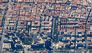
AZCA, an acronym for Asociación Mixta de Compensación de la Manzana A de la Zona Comercial de la Avenida del Generalísimo ("Mixed Association for Compensation of the A Block of the Commercial Area of the Avenue of the Generalisimo", now called the Avenue of Paseo de la Castellana), is a financial district in Madrid, Spain. The business district, which is located on the northern edge of the city centre, serves as one of the two main financial districts of the Madrid metropolitan area.

Nuevos Ministerios (Madrid Metro)
Madrid Metro station
Distance: Approx. 198 meters
Latitude and longitude: 40.4466221,-3.6924595
Nuevos Ministerios [ˈnweβos minisˈteɾjos] is a major multimodal rail station on the Madrid Metro and the Cercanías Madrid commuter rail network. It is located beneath the Nuevos Ministerios (New Ministries) government complex and the AZCA financial centre at the junction of the Paseo de la Castellana and Joaquín Costa and Raimundo Fernández Villaverde streets in Madrid, Spain. It services the districts of Tetuán, Chamberí, and Chamartín.

Torre Mahou
Skyscraper in Madrid
Distance: Approx. 79 meters
Latitude and longitude: 40.44861111,-3.69416667
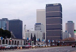
Edificio Alfredo Mahou (Alfredo Mahou Building), also known as Torre Mahou (Mahou Tower) is a skyscraper in the AZCA Complex, Madrid, Spain. It coexists with the Torre del Banco de Bilbao, the Torre Europa and the Picasso Tower. It is the 17th tallest building in Madrid, at 85 metres / 279 ft.

El Pozo railway station
Distance: Approx. 209 meters
Latitude and longitude: 40.44666667,-3.69222222
El Pozo Station is a Cercanías station in Vallecas neighborhood (Madrid). It was opened on July 15, 1992, and it is located in El Pozo area. It belongs to lines C-2 and C-7 of Cercanías Madrid.

Torre Titania
Skyscraper in Madrid, Spain
Distance: Approx. 127 meters
Latitude and longitude: 40.4468,-3.6945
Torre Titania is the twelfth-tallest skyscraper in Madrid, Spain and has become the country's largest mall. Construction began in mid-2007, after the burning of the Windsor Tower, which formerly occupied the site. The interior, which houses stores El Corte Inglés, was completed in October 2011, and the facade in late 2013.

Hipódromo de la Castellana
Spanish horse racetrack in Madrid
Distance: Approx. 330 meters
Latitude and longitude: 40.4451,-3.6928
The Hipódromo de la Castellana, also known as the Hipódromo de Madrid, was a sports facility dedicated to horse racing. Located on the Paseo de la Castellana in Madrid, Spain, it was designed by engineer Francisco Boguerín as one of the first official horse racing tracks in the city. The Hipódromo was inaguruated to celebrate the wedding of King Alfonso XII in 1878.

Cuatro Caminos (Madrid)
City neighborhood in Madrid, Community of Madrid, Spain
Distance: Approx. 303 meters
Latitude and longitude: 40.45027778,-3.69583333
Cuatro Caminos is an administrative neighborhood (barrio) of Madrid belonging to the district of Tetuán. It has an area of 1.193509 km2 (0.460816 sq mi). As of 1 February 2020, it has a population of 35,395.

Spanish Aviation Safety and Security Agency
Distance: Approx. 357 meters
Latitude and longitude: 40.451,-3.693
The Spanish Aviation Safety and Security Agency, also known by the acronym AESA (Spanish: Agencia Estatal de Seguridad Aérea), is the civil aviation authority for Spain. The agency is based in Madrid, where it occupies offices on the Paseo de la Castellana.

Nuevos Ministerios
Distance: Approx. 437 meters
Latitude and longitude: 40.444,-3.6935
Nuevos Ministerios (English: New Ministries) is a government complex in central Madrid, Spain. The complex houses several government departments: Development, Labour, Social Security, and Ecological Transition. It is located in the block delimited by the Paseo de la Castellana, the Raimundo Fernández Villaverde street, Agustín de Betancourt street and the San Juan de la Cruz square.

Monument to José Martí (Madrid)
Monument in Madrid
Distance: Approx. 446 meters
Latitude and longitude: 40.449292,-3.689156
The Monument to José Martí is an instance of public art in Madrid, Spain. A gift from the Republic of Cuba to Madrid, the monument is dedicated to José Martí, a Cuban writer and activist noted for his struggle in favour of the independence from Spain.
Weather in this IP's area
clear sky
16 Celsius
16 Celsius
15 Celsius
17 Celsius
1024 hPa
65 %
1024 hPa
943 hPa
10000 meters
3.09 m/s
320 degree
07:55:30
18:02:04
