Country:
Region:
City:
Latitude and Longitude:
Time Zone:
Postal Code:
IP information under different IP Channel
ip-api
Country
Region
City
ASN
Time Zone
ISP
Blacklist
Proxy
Latitude
Longitude
Postal
Route
Luminati
Country
ASN
Time Zone
Europe/Stockholm
ISP
Telenor Norge AS
Latitude
Longitude
Postal
IPinfo
Country
Region
City
ASN
Time Zone
ISP
Blacklist
Proxy
Latitude
Longitude
Postal
Route
db-ip
Country
Region
City
ASN
Time Zone
ISP
Blacklist
Proxy
Latitude
Longitude
Postal
Route
ipdata
Country
Region
City
ASN
Time Zone
ISP
Blacklist
Proxy
Latitude
Longitude
Postal
Route
Popular places and events near this IP address
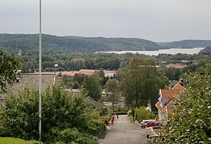
Härryda Municipality
Municipality in Västra Götaland County, Sweden
Distance: Approx. 953 meters
Latitude and longitude: 57.66666667,12.11666667
Härryda Municipality (Härryda kommun) is a municipality in Västra Götaland County in western Sweden. Its seat is located in the town of Mölnlycke, with about 19,000 inhabitants. Göteborg Landvetter Airport, Sweden's second-largest airport is situated near the locality of Härryda, after which the municipality is named.

Landvetter
Place in Västergötland, Sweden
Distance: Approx. 5575 meters
Latitude and longitude: 57.68333333,12.2
Landvetter is a locality situated in Härryda Municipality, Västra Götaland County, Sweden. It had 7,152 inhabitants in 2010. It is the second largest town in the municipality and has given its name to the international airport Göteborg Landvetter Airport, located 5 km east of Landvetter.

Mölnlycke
Place in Västergötland, Sweden
Distance: Approx. 953 meters
Latitude and longitude: 57.66666667,12.11666667
Mölnlycke is a small town nearby Greater Gothenburg, a locality and the seat of Härryda Municipality, Västra Götaland County, Sweden. It had 17,499 inhabitants in 2019. The urban area stretches over two municipalities.

Brudaremossen masts
Distance: Approx. 5324 meters
Latitude and longitude: 57.69361111,12.05888889
The Brudaremossen mast (Swedish: Brudaremossenmasten) is a 331 metres (1,086 ft) high mast in Delsjön in eastern Gothenburg, Sweden, built in 1980 to replace the overloaded, 20-year-old TV tower. Brudaremossen TV tower is a 70-metre (230 ft) high concrete tower with a guyed lattice steel mast on its top. The complete structure is 172 metres (564 ft) tall.

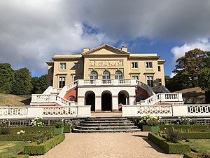
Gunnebo House
Distance: Approx. 3613 meters
Latitude and longitude: 57.65805556,12.05833333
Gunnebo House (Swedish: Gunnebo slott) is a mansion located outside Gothenburg, in Mölndal Municipality, Sweden. The main building, the garden facilities, the park and a larger outdoor area, were registered as a building monument and protected as a nature reserve in 1949.

Delsjön
Distance: Approx. 5262 meters
Latitude and longitude: 57.68472222,12.04583333
Delsjön consist of two coherent lakes, Stora Delsjön and Lilla Delsjön, located in eastern Gothenburg, in the Delsjöområdet nature reserve. They serve as a reservoir for the city, receiving water from the Göta River. At the shore of Stora Delsjön there is a popular beach.
Tulebo
Place in Västergötland, Sweden
Distance: Approx. 4760 meters
Latitude and longitude: 57.61666667,12.1
Tulebo is a locality situated in Mölndal Municipality, Västra Götaland County, Sweden with 213 inhabitants in 2010.
Öjersjö
Place in Västergötland, Sweden
Distance: Approx. 4655 meters
Latitude and longitude: 57.7,12.11666667
Öjersjö is a locality situated in Partille Municipality, Västra Götaland County, Sweden with 3,543 inhabitants in 2010.
Benareby
Place in Västergötland, Sweden
Distance: Approx. 2982 meters
Latitude and longitude: 57.65,12.16666667
Benareby is a locality situated in Härryda Municipality, Västra Götaland County, Sweden. It had 384 inhabitants in 2010.
Nya Långenäs
Place in Västergötland, Sweden
Distance: Approx. 2982 meters
Latitude and longitude: 57.65,12.16666667
Nya Långenäs is a locality situated in Härryda Municipality, Västra Götaland County, Sweden. It had 268 inhabitants in 2010.

Pixbo
Distance: Approx. 2234 meters
Latitude and longitude: 57.65095,12.08403
Pixbo is a locality in Västergötland, Sweden. Most of it lies within Härryda Municipality, except for a minor part which belongs to Mölndal Municipality. The urban area to which it belongs is Mölnlycke.
Gökskulla
Distance: Approx. 5009 meters
Latitude and longitude: 57.6928,12.1728
Gökskulla is a residential area in Tahult, Landvetter in Härryda Municipality in Sweden. Television presenter Clara Henry was born here.
Weather in this IP's area
broken clouds
4 Celsius
2 Celsius
3 Celsius
7 Celsius
992 hPa
86 %
992 hPa
985 hPa
10000 meters
2.94 m/s
6.3 m/s
264 degree
75 %
08:01:21
15:52:01


