194.63.116.98 - IP Lookup: Free IP Address Lookup, Postal Code Lookup, IP Location Lookup, IP ASN, Public IP
Country:
 Great Britain
Region:
City:
Location:
Time Zone:
Postal Code:
ISP:
ASN:
language:
User-Agent:
Proxy IP:
Blacklist:
IP information under different IP Channel
ip-api
Country
Region
City
ASN
Time Zone
ISP
Blacklist
Proxy
Latitude
Longitude
Postal
Route
db-ip
Country
Region
City
ASN
Time Zone
ISP
Blacklist
Proxy
Latitude
Longitude
Postal
Route
IPinfo
Country
Region
City
ASN
Time Zone
ISP
Blacklist
Proxy
Latitude
Longitude
Postal
Route
IP2Location
194.63.116.98Country
gbRegion
wales
City
treherbert
Time Zone
Europe/London
ISP
Language
User-Agent
Latitude
Longitude
Postal
ipdata
Country
Region
City
ASN
Time Zone
ISP
Blacklist
Proxy
Latitude
Longitude
Postal
Route
Popular places and events near this IP address

Treherbert
Village in Rhondda Cynon Taf, Wales
Distance: Approx. 109 meters
Latitude and longitude: 51.6722,-3.5306
Treherbert () is a village and community situated at the head of the Rhondda Fawr valley in the county borough of Rhondda Cynon Taf, Wales. Historically part of Glamorgan. Treherbert is the upper most community of the Rhondda Fawr and encompasses the districts of Blaencwm, Blaenrhondda, Tynewydd and Pen-yr-englyn.

Ynyswen railway station
Railway station in Rhondda Cynon Taff, Wales
Distance: Approx. 910 meters
Latitude and longitude: 51.665,-3.5215
Ynyswen railway station () is a railway station serving the village of Ynyswen in Rhondda Cynon Taf, south Wales. It is located on the Rhondda Line. It was first opened on this site by British Rail on the former Taff Vale Railway in 1986.
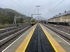
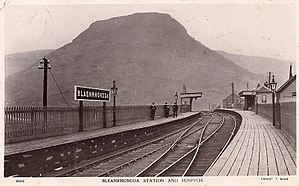
Treherbert railway station
Railway station in Rhondda Cynon Taf, Wales
Distance: Approx. 410 meters
Latitude and longitude: 51.6718,-3.5356
Treherbert railway station serves the village of Treherbert in Rhondda Cynon Taf, Wales. It is the northern terminus of the Rhondda Line.

Parc and Dare Hall
Distance: Approx. 2125 meters
Latitude and longitude: 51.659,-3.5063
The Parc and Dare Hall, now known as the Park and Dare Theatre (Welsh: Theatr y Parc a'r Dâr), is a former Miners' institute but now serves as a large entertainment venue in the village of Treorchy, in the Rhondda Valley of Wales. Since the demolition of the Abercynon Workingmen's Hall, the Parc and Dare Workingmen's Hall is the largest in the South Wales Coalfield. It is a Grade II* listed building.

Ynyswen
Welsh town
Distance: Approx. 1136 meters
Latitude and longitude: 51.665583,-3.516179
Ynyswen (; meaning White island) is a village in the community of Treorchy, in the county borough of Rhondda Cynon Taf, Wales. Ynyswen consists mostly of housing. It has an industrial estate which was once the site of Burberry's factory, one shop, and the Forest View Medical Centre.

Blaenrhondda
Human settlement in Wales
Distance: Approx. 2106 meters
Latitude and longitude: 51.6847,-3.5514
Blaenrhondda is a village in the county borough of Rhondda Cynon Taf, Wales, lying at the head the Rhondda Fawr valley. Blaenrhondda is a village and is part of the community of Treherbert.

Tynewydd, Rhondda Cynon Taf
Human settlement in Wales
Distance: Approx. 1585 meters
Latitude and longitude: 51.68,-3.548
Tynewydd is a village located in the County Borough of Rhondda Cynon Taf, south Wales. With Treherbert, Blaencwm, Blaenrhondda and Pen-yr-englyn it is part of a community of Treherbert. The village lies in the former industrial coal mining area at the head of Rhondda Fawr, the larger of the Rhondda Valleys.
Blaenrhondda railway station
Disused railway station in Blaenrhondda, Rhondda Cynon Taf
Distance: Approx. 1609 meters
Latitude and longitude: 51.6795,-3.549
Blaenrhondda railway station served the village of Blaenrhondda, in the historical county of Glamorganshire, Wales, from 1890 to 1968 on the Rhondda and Swansea Bay Railway.
Mynydd Ty-Isaf, Rhondda
Distance: Approx. 1936 meters
Latitude and longitude: 51.659709,-3.5504665
Mynydd Ty-Isaf, Rhondda is a Site of Special Scientific Interest near Treherbert in Rhondda Cynon Taf, south Wales.

Noddfa Chapel, Treorchy
Former chapel in Treorchy, Rhondda Cynon Taf, Wales
Distance: Approx. 2024 meters
Latitude and longitude: 51.6602,-3.5066
Noddfa or Noddfa Welsh Baptist Chapel (Welsh: Capel Bedyddwyr Cymraeg Noddfa), was located in Treorchy in the Rhondda Valley. It was one of the largest Baptist churches in the South Wales valleys, and one of the largest and grandest of all Welsh chapels.
Bute Merthyr Colliery
Welsh coal mine active 1851-1926
Distance: Approx. 893 meters
Latitude and longitude: 51.67444444,-3.54166667
The Bute Merthyr Colliery, in Treherbert in the Rhondda Valley, was the first colliery to produce steam coal in the Rhondda valley. A trial pit was dug in 1851, and the colliery was closed in 1926.
Tylacoch Halt railway station
Short-lived railway station in Ynyswen, Rhondda Cynon Taf
Distance: Approx. 1068 meters
Latitude and longitude: 51.6643,-3.5193
Tylacoch Halt railway station served the village of Ynyswen, in the historic county of Glamorgan, Wales, from 1906 to 1912 on the Taff Vale Railway.
Weather in this IP's area
light snow
2 Celsius
-4 Celsius
1 Celsius
2 Celsius
1020 hPa
92 %
1020 hPa
989 hPa
8214 meters
6.89 m/s
13.57 m/s
52 degree
91 %