Country:
 Germany
Region:
City:
Latitude and Longitude:
Time Zone:
Postal Code:
IP information under different IP Channel
ip-api
Country
Region
City
ASN
Time Zone
ISP
Blacklist
Proxy
Latitude
Longitude
Postal
Route
IPinfo
Country
Region
City
ASN
Time Zone
ISP
Blacklist
Proxy
Latitude
Longitude
Postal
Route
MaxMind
Country
Region
City
ASN
Time Zone
ISP
Blacklist
Proxy
Latitude
Longitude
Postal
Route
Luminati
Country
DEASN
Time Zone
Europe/Berlin
ISP
Hetzner Online GmbH
Latitude
Longitude
Postal
db-ip
Country
Region
City
ASN
Time Zone
ISP
Blacklist
Proxy
Latitude
Longitude
Postal
Route
ipdata
Country
Region
City
ASN
Time Zone
ISP
Blacklist
Proxy
Latitude
Longitude
Postal
Route
Popular places and events near this IP address

Nuremberg
City in Bavaria, Germany
Distance: Approx. 215 meters
Latitude and longitude: 49.45388889,11.0775
Nuremberg ( NURE-əm-burg; German: Nürnberg [ˈnʏʁnbɛʁk] ; in the local East Franconian dialect: Nämberch [ˈnɛmbɛrç]) is the largest city in Franconia, the second-largest city in the German state of Bavaria, and its 544,414 (2023) inhabitants make it the 14th-largest city in Germany. Nuremberg sits on the Pegnitz, which carries the name Regnitz from its confluence with the Rednitz in Fürth onwards (Pegnitz→ Regnitz→ Main→ Rhine→ North Sea), and on the Rhine–Main–Danube Canal, that connects the North Sea to the Black Sea. Lying in the Bavarian administrative region of Middle Franconia, it is the largest city and unofficial capital of the entire cultural region of Franconia.
Nuremberg Toy Museum
Toy Museum in Nuremberg
Distance: Approx. 48 meters
Latitude and longitude: 49.45472222,11.07444444
The Nuremberg Toy Museum (also known as Lydia Bayer Museum) in Nuremberg, Bavaria, is a municipal museum, which was founded in 1971. It is considered to be one of the most well known toy museums in the world, depicting the cultural history of toys from antiquity to the present.

Christkindlesmarkt, Nuremberg
Annual Christmas market in Nuremberg, Bavaria, Germany
Distance: Approx. 177 meters
Latitude and longitude: 49.454,11.077
Christkindlesmarkt is a Christmas market that is held annually in Nuremberg, Germany. It takes place during Advent in the Hauptmarkt, the central square in Nuremberg’s old town, and in adjoining squares and streets. With about two million visitors a year the Nürnberger Christkindlesmarkt is one of the largest Christmas markets in Germany and one of the most famous in the world.

St. Sebaldus Church, Nuremberg
Church in Nuremberg, Germany
Distance: Approx. 169 meters
Latitude and longitude: 49.45527778,11.07638889
St. Sebaldus Church (St. Sebald, Sebalduskirche) is a medieval church in Nuremberg, Germany.
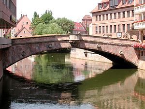
Fleisch Bridge
Late Renaissance bridge in Nuremberg, Germany
Distance: Approx. 226 meters
Latitude and longitude: 49.453,11.077
The Fleisch Bridge (German: Fleischbrücke or "Meat Bridge") or Pegnitz Bridge (Pegnitzbrücke) is a late Renaissance bridge in Nuremberg, Germany. The bridge crosses the river Pegnitz in the center of the old town, linking the districts St. Sebald and St.
Center for Transportation and Logistics Neuer Adler
Distance: Approx. 378 meters
Latitude and longitude: 49.456049,11.07908
Center for Transportation and Logistics Neuer Adler (CNA) is a German association for industries active in the transport and logistics sectors. The name "Neuer Adler" alludes to Adler, the first railway locomotive in Germany.

Frauenkirche, Nuremberg
Church in Nuremberg, Germany
Distance: Approx. 248 meters
Latitude and longitude: 49.454,11.078
The Frauenkirche ("Church of Our Lady") is a church in Nuremberg, Germany. It stands on the eastern side of the main market. An example of brick Gothic architecture, it was built on the initiative of Charles IV, Holy Roman Emperor between 1352 and 1362.
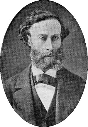
Leopold Einstein
Distance: Approx. 140 meters
Latitude and longitude: 49.45543056,11.07373889
Leopold Einstein (born Leopold Löb, 1833, died 8 September 1890 in Nuremberg) was a Jewish teacher, vendor, and writer. He was one of the early proponents of Esperanto. He was the first chairperson of the "Nürnberger Weltspracheverein", a Volapük organization founded on 18 February 1885, and remained chairperson until his resignation due to poor health on 22 February 1888.
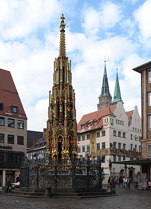
Schöner Brunnen
Gothic fountain in Nuremberg
Distance: Approx. 178 meters
Latitude and longitude: 49.45423056,11.07705556
Schöner Brunnen (en:beautiful fountain) is a 14th-century fountain located on Nuremberg's main market next to the town hall and is considered one of the main attractions of the city's Historical Mile. The fountain is approximately 19 metres high and has the shape of a Gothic spire.

Albrecht Dürer's House
Biographical museum in Nuremberg
Distance: Approx. 329 meters
Latitude and longitude: 49.45722222,11.07388889
Albrecht Dürer's House (German: Albrecht-Dürer-Haus) is a Nuremberg Fachwerkhaus that was the home of German Renaissance artist Albrecht Dürer from 1509 to his death in 1528. The House lies in the extreme north-west of Nuremberg's Altstadt, near the Kaiserburg section of the Nuremberg Castle and the Tiergärtnertor of Nuremberg's city walls. The house was built around 1420.
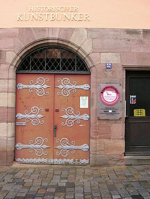
Historischer Kunstbunker
Distance: Approx. 273 meters
Latitude and longitude: 49.4567,11.0754
The Historische Kunstbunker (Historic art bunker) is a tunnel complex under Nuremberg Castle in the old city of Nuremberg, southern Germany. It forms part of the Nuremberg Historic Mile. In the Middle Ages, a network of rock passages was built in the hard sandstone of the castle.

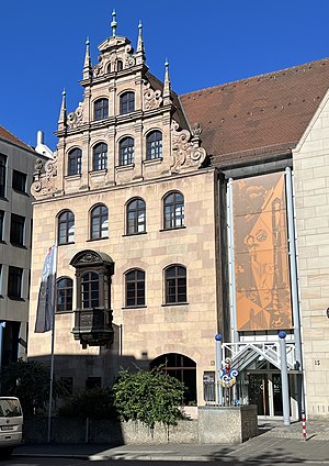
Nuremberg City Hall
City Hall in Nuremberg, Germany
Distance: Approx. 236 meters
Latitude and longitude: 49.45519444,11.07755556
Nuremberg City Hall (German: Nürnberger Rathaus) is located in the old town of Nuremberg, Germany, just east of the choir of the Sebalduskirche. It is part of the Historic Mile of Nuremberg as one of the city's sights. The imposing Renaissance building was designed by architect Jakob Wolff the Younger (1571–1620).
Weather in this IP's area
clear sky
16 Celsius
16 Celsius
15 Celsius
18 Celsius
1022 hPa
65 %
1022 hPa
986 hPa
10000 meters
4.12 m/s
60 degree
06:58:08
19:20:47