Country:
Region:
City:
Latitude and Longitude:
Time Zone:
Postal Code:
IP information under different IP Channel
ip-api
Country
Region
City
ASN
Time Zone
ISP
Blacklist
Proxy
Latitude
Longitude
Postal
Route
Luminati
Country
Region
3
City
wilhelmsburg
ASN
Time Zone
Europe/Vienna
ISP
NETPLANET GmbH
Latitude
Longitude
Postal
IPinfo
Country
Region
City
ASN
Time Zone
ISP
Blacklist
Proxy
Latitude
Longitude
Postal
Route
db-ip
Country
Region
City
ASN
Time Zone
ISP
Blacklist
Proxy
Latitude
Longitude
Postal
Route
ipdata
Country
Region
City
ASN
Time Zone
ISP
Blacklist
Proxy
Latitude
Longitude
Postal
Route
Popular places and events near this IP address

Gölsen
River in Lower Austria, Austria
Distance: Approx. 6079 meters
Latitude and longitude: 48.052,15.612
The Gölsen is a river in Lower Austria, in the Mostviertel. It is a right tributary of the Traisen. Its drainage basin is 297 km2 (115 sq mi).
St. Pölten District
District in Lower Austria, Austria
Distance: Approx. 9468 meters
Latitude and longitude: 48.183,15.667
Bezirk St. Pölten is a district of the state of Lower Austria in Austria. It completely surrounds the city of St.

New Design University St. Pölten
Distance: Approx. 9026 meters
Latitude and longitude: 48.1875,15.61916667
The New Design University St. Pölten is a private university in St. Pölten, Austria.

Pyhra
Place in Lower Austria, Austria
Distance: Approx. 7227 meters
Latitude and longitude: 48.15,15.68333333
Pyhra (German pronunciation: [ˈpyːʁa] ) is a town with 3286 inhabitants in the district of Sankt Pölten-Land in Lower Austria, Austria.
Eschenau
Place in Lower Austria, Austria
Distance: Approx. 8797 meters
Latitude and longitude: 48.03333333,15.56666667
Eschenau is a town in the district of Lilienfeld in the Austrian state of Lower Austria.

Sankt Veit an der Gölsen
Place in Lower Austria, Austria
Distance: Approx. 9147 meters
Latitude and longitude: 48.03333333,15.66666667
Sankt Veit an der Gölsen is a town in the district of Lilienfeld in the Austrian federal state of Lower Austria.
Traisen, Austria
Place in Lower Austria, Austria
Distance: Approx. 6315 meters
Latitude and longitude: 48.05,15.61666667
Traisen (German pronunciation: [ˈtʀaɪ̯zn̩] , pronunciation in local German dialect [ˈtʀoːazn̩] ) is a town in the district of Lilienfeld in the Austrian state of Lower Austria.

Hofstetten-Grünau
Place in Lower Austria, Austria
Distance: Approx. 8650 meters
Latitude and longitude: 48.08333333,15.5
Hofstetten-Grünau is a town in the district of Sankt Pölten-Land in the Austrian state of Lower Austria.
Ober-Grafendorf
Place in Lower Austria, Austria
Distance: Approx. 7526 meters
Latitude and longitude: 48.15,15.53333333
Ober-Grafendorf is a municipality in the district of Sankt Pölten-Land in the Austrian state of Lower Austria.
Weinburg
Place in Lower Austria, Austria
Distance: Approx. 5820 meters
Latitude and longitude: 48.1,15.53333333
Weinburg is a municipality in the district of Sankt Pölten-Land in the Austrian state of Lower Austria.

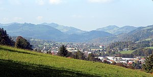
Wilhelmsburg, Austria
Place in Lower Austria, Austria
Distance: Approx. 477 meters
Latitude and longitude: 48.11083333,15.61
Wilhelmsburg is a municipality in the district of Sankt Pölten-Land District in the Austrian state of Lower Austria.

Völtendorf Airport
Airport in Austria
Distance: Approx. 6215 meters
Latitude and longitude: 48.16025,15.58786111
Völtendorf Airport (German: Flugplatz Völtendorf, ICAO: LOAD) is a private use airport located 0 kilometres (0 mi) west-southwest of Völtendorf, Lower Austria, Austria.
Weather in this IP's area
light rain
4 Celsius
2 Celsius
3 Celsius
6 Celsius
1014 hPa
99 %
1014 hPa
977 hPa
10000 meters
2.86 m/s
9.47 m/s
247 degree
100 %
07:09:14
16:16:38


