Country:
 Germany
Region:
City:
Latitude and Longitude:
Time Zone:
Postal Code:
IP information under different IP Channel
ip-api
Country
Region
City
ASN
Time Zone
ISP
Blacklist
Proxy
Latitude
Longitude
Postal
Route
IPinfo
Country
Region
City
ASN
Time Zone
ISP
Blacklist
Proxy
Latitude
Longitude
Postal
Route
MaxMind
Country
Region
City
ASN
Time Zone
ISP
Blacklist
Proxy
Latitude
Longitude
Postal
Route
Luminati
Country
DEASN
Time Zone
Europe/Berlin
ISP
R-KOM Regensburger Telekommunikationsgesellschaft mbH
Latitude
Longitude
Postal
db-ip
Country
Region
City
ASN
Time Zone
ISP
Blacklist
Proxy
Latitude
Longitude
Postal
Route
ipdata
Country
Region
City
ASN
Time Zone
ISP
Blacklist
Proxy
Latitude
Longitude
Postal
Route
Popular places and events near this IP address
Regen (river)
River in Germany
Distance: Approx. 765 meters
Latitude and longitude: 49.02638889,12.10361111
The Regen (German pronunciation: [ˈʁeːɡən]; Czech: Řezná) is a river in Bavaria, Germany, and for a short distance in the Czech Republic. It is a left tributary of the Danube, at Regensburg, Germany.

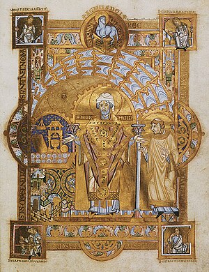
Regensburg Cathedral
Church in Regensburg, Germany
Distance: Approx. 1629 meters
Latitude and longitude: 49.01944444,12.09833333
Regensburg Cathedral (German: Dom St. Peter or Regensburger Dom), also known as St. Peter's Cathedral, is an example of important Gothic architecture within the German state of Bavaria.

Roman Catholic Diocese of Regensburg
Roman Catholic diocese in Germany
Distance: Approx. 1638 meters
Latitude and longitude: 49.01944444,12.09805556
The Diocese of Regensburg (Latin: Dioecesis Ratisbonensis) is a Latin Church diocese of the Catholic Church with its episcopal see based in Regensburg, Germany. Its district covers parts of northeastern Bavaria; it is subordinate to the archbishop of Munich and Freising. As of 2014, the diocese had 1.20 million Catholics, constituting 70% of its total population.
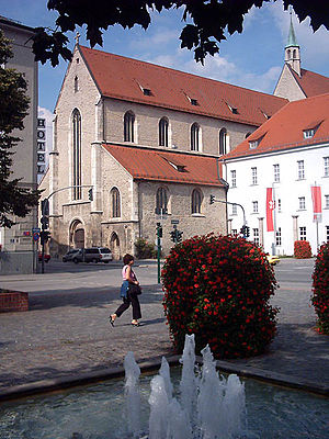
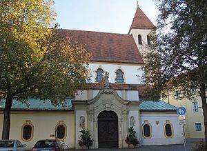
Niedermünster, Regensburg
Distance: Approx. 1565 meters
Latitude and longitude: 49.01944444,12.10055556
The Niedermünster or Niedermünster Abbey (German: Reichsstift Niedermünster), Regensburg, was a house of canonesses (Frauenstift) in Regensburg, Bavaria, Germany. At the height of its power it was one of the wealthiest and most influential in Bavaria. The church is still in use as the parish church of Regensburg Cathedral.
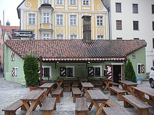
Regensburg Sausage Kitchen
Restaurant in Regensburg, Germany
Distance: Approx. 1495 meters
Latitude and longitude: 49.02111111,12.0975
The Historic Sausage Kitchen of Regensburg (German: Historische Wurstküche zu Regensburg) is a restaurant in Regensburg, Germany. This is notable as perhaps the oldest continuously open public restaurant in the world. In 1135 AD a building was erected as the construction office for the Regensburg stone bridge.
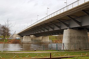
Nibelungen Bridge (Regensburg)
Road structure in Regensburg, Germany
Distance: Approx. 1299 meters
Latitude and longitude: 49.02138889,12.11305556
The Nibelungen Bridge (German: Nibelungenbrücke) is a dual road bridge with two sections spanning both arms of the Danube at kilometre mark 2378.39 in Regensburg, Germany. The current bridge, the third on the site, was erected in 2001–04 to replace a bridge erected in 1950 which was no longer adequate for traffic demands, and which had replaced a bridge built in 1938 and destroyed in World War II. Carrying an average of 42,000 vehicles a day, it is one of the most important bridges in the Regensburg area.

Stone Bridge (Regensburg)
Bridge
Distance: Approx. 1351 meters
Latitude and longitude: 49.02277778,12.09722222
The Stone Bridge (Steinerne Brücke) in Regensburg, Germany, is a 12th-century bridge across the Danube linking the Old Town with Stadtamhof. For more than 800 years, until the 1930s, it was the city's only bridge across the river. It is a masterwork of medieval construction and an emblem of the city.

Regensburg Museum of Danube Shipping
Museum in Germany
Distance: Approx. 1411 meters
Latitude and longitude: 49.020915,12.10062
The Regensburg Museum of Danube Shipping (Donau-Schiffahrts-Museum Regensburg) is a maritime museum of river shipping on the river Danube and other rivers, situated in the city of Regensburg in Germany. It also contains art collections on that topic, along with material on boatmen's work and training. Its main exhibits are the steam tugboat Ruthof / Érsekcsanád and the diesel tug Freudenau.
Regensburg Museum of History
Museum of the history, art and culture of Regensburg and eastern Bavaria
Distance: Approx. 1680 meters
Latitude and longitude: 49.01805556,12.10194444
The Regensburg Museum of History (Regensburg Historische Museum) currently resides in a former Minorite monastery, is a museum of the history, art and culture of Regensburg and eastern Bavaria from the Stone Age to the present day. The former monastery of St Salvator, located in the city's Dachauplatz district, was founded in 1221 by the Bishop of Regensburg Konrad IV of Frontenhausen, Count Otto VIII of Bavaria, and King Henry VII. The three-naved basilica church was considered the largest church of the order in southern Germany until its closure in 1799. The church and most of its monastic buildings survived, with the monastic buildings converted as barracks and billets for the Bavarian Army, and the church as a customs hall, a drill hall and a hotel until it became the location of the Regensburg Museum of History in 1931.
Basilica of the Nativity of Our Lady, Regensburg
Church in Regensburg, Germany
Distance: Approx. 1689 meters
Latitude and longitude: 49.01837,12.10007
The Basilica of the Nativity of Our Lady also Basilica of the Nativity of Our Lady to the Ancient Chapel (German: Basilika Unserer Lieben Frau Zur Alten Kapelle ) or Alten Kapelle It is the oldest Catholic place of worship in Bavaria and one of the most important churches in the city of Regensburg, in the south of Germany. The collegiate church and smaller basilica is part of an old abbey dedicated to the Virgin founded by the emperor Henry II, ruler of the Holy Roman Empire in the 1002. With a baroque style of the 18th century, it is one of the masterpieces of the rococo decoration in Europe, in the style dictated by the School of renown Wessobrunn.
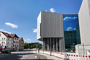
Haus der Bayerischen Geschichte: Museum
History museum in Regensburg, Germany
Distance: Approx. 1458 meters
Latitude and longitude: 49.0199,12.1032
The Haus der Bayerischen Geschichte: Museum (aka Museum der Bayerischen Geschichte) is a history museum about the history of Bavaria, located in Regensburg. It is part of Haus der Bayerischen Geschichte (Munich) which is financed by the state government. It opened on June 5, 2019.

Regensburg subcamp
Subcamp of Flossenbürg concentration camp
Distance: Approx. 1180 meters
Latitude and longitude: 49.0248361,12.0970996
The Regensburg satellite camp (KZ-Außenlager Regensburg) (Stadtamhof, Regensburg, Bavaria, Germany), also known as the Colosseum subcamp (Außenkommando Colosseum) in the vernacular at the time, was established in 1945 as the last subcamp of the Flossenbürg concentration camp in the Regensburg inn the Kolosseum (originally spelled with K). The Regensburg subcamp was in operation from March 19, 1945, until April 23, 1945. The Colosseum building is located at Stadtamhof 5, approximately 200 meters north of the Danube across the Stone Bridge (Steinerne Brücke) from the Altstadt (old town).
Weather in this IP's area
scattered clouds
14 Celsius
14 Celsius
14 Celsius
15 Celsius
1021 hPa
74 %
1021 hPa
981 hPa
10000 meters
2.68 m/s
4.92 m/s
40 degree
32 %
06:54:08
19:16:31