Country:
 Netherlands
Region:
City:
Latitude and Longitude:
Time Zone:
Postal Code:
IP information under different IP Channel
ip-api
Country
Region
City
ASN
Time Zone
ISP
Blacklist
Proxy
Latitude
Longitude
Postal
Route
IPinfo
Country
Region
City
ASN
Time Zone
ISP
Blacklist
Proxy
Latitude
Longitude
Postal
Route
MaxMind
Country
Region
City
ASN
Time Zone
ISP
Blacklist
Proxy
Latitude
Longitude
Postal
Route
Luminati
Country
NLASN
Time Zone
Europe/Amsterdam
ISP
BIT BV
Latitude
Longitude
Postal
db-ip
Country
Region
City
ASN
Time Zone
ISP
Blacklist
Proxy
Latitude
Longitude
Postal
Route
ipdata
Country
Region
City
ASN
Time Zone
ISP
Blacklist
Proxy
Latitude
Longitude
Postal
Route
Popular places and events near this IP address

Wageningen
Municipality in Gelderland, Netherlands
Distance: Approx. 1724 meters
Latitude and longitude: 51.96666667,5.66666667
Wageningen (Dutch pronunciation: [ˈʋaːɣənɪŋə(n)] ) is a municipality and a historic city in the central Netherlands, in the province of Gelderland. It is famous for Wageningen University, which specialises in life sciences. The municipality had a population of 39,635 in 2021, of which many thousands are students from over 150 countries.

Wageningen University & Research
Agricultural university in Wageningen, Netherlands
Distance: Approx. 1327 meters
Latitude and longitude: 51.96708889,5.65860278
Wageningen University & Research (also known as Wageningen UR; abbreviation: WUR) is a public research university in Wageningen, Netherlands, specializing in life sciences with a focus on agriculture, technical and engineering subjects. It is a globally important center for life sciences and agricultural research. It is located in a region of the Netherlands known as the Food Valley.
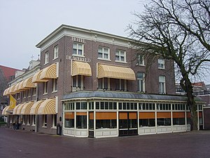
Hotel de Wereld
Hotel where WWII Nazi German forces in Netherlands capitulated
Distance: Approx. 1722 meters
Latitude and longitude: 51.9675,5.66777778
Hotel de Wereld (meaning Hotel The World) is a 4-star hotel in Wageningen. It was the site of the capitulation of the German troops in the Netherlands on 5 May 1945, and the end of German occupation during World War II. Oberbefehlshaber Niederlande supreme commander Generaloberst Johannes Blaskowitz surrendered to I Canadian Corps commander Lieutenant-General Charles Foulkes at the hotel. The capitulation document was signed the next day (no typewriter had been available the prior day) in the auditorium of Rijks Landbouw Hoogeschool, located next door.
Bennekom
Village in Gelderland, Netherlands
Distance: Approx. 3120 meters
Latitude and longitude: 51.99944444,5.67555556
Bennekom is a village and parish in the Netherlands, which is part of the Municipality of Ede in the south-west of the Veluwe district of the Province of Gelderland. It adjoins the town of Wageningen on the Lower-Rhine to the south, and Ede to the north, Veenendaal to the west and Renkum to the east. The western boundary of the parish follows the canalized River Grift and is also the boundary with the Province of Utrecht.

Grebbeberg
Hill in Rhenen in the Netherlands
Distance: Approx. 4182 meters
Latitude and longitude: 51.954,5.6
The Grebbeberg is a 52-meter high hill located east of Rhenen, Netherlands in the province of Utrecht. It forms the southeastern tip of the Utrecht Hill Ridge, a moraine. Due to its strategic location with a view of the Lower Rhine and the Betuwe, this hill was historically of great importance.
Battle of the Grebbeberg
Major engagement during the Battle of the Netherlands in WWII
Distance: Approx. 4182 meters
Latitude and longitude: 51.954,5.6
The Battle of the Grebbeberg (Dutch: Slag om de Grebbeberg) was a major engagement during the Battle of the Netherlands, which was a part of the World War II Operation Fall Gelb in 1940.

Wageningse Berg
Distance: Approx. 2935 meters
Latitude and longitude: 51.965,5.68611111
The Wageningse Berg (Dutch pronunciation: [ˈʋaːɣənɪŋsə ˈbɛr(ə)x]) is the southernmost part of the Utrechtse Heuvelrug (Utrecht Hill Ridge), a range of hills reaching an altitude of 52m that originated as a glacial moraine. It lies just north of the Nederrijn and to the east of the town of Wageningen.
Wageningen-Hoog
Township in Gelderland, Netherlands
Distance: Approx. 3351 meters
Latitude and longitude: 51.98888889,5.69305556
Wageningen-Hoog is a township in the town of Wageningen in the central Netherlands, in the province of Gelderland. Wageningen-Hoog is located alongside the Village Bennekom in the town Ede. Wageningen-Hoog is spacious with villa's in a wooded area.

Grebbeberg War Cemetery
WWII cemetery in the Netherlands
Distance: Approx. 4045 meters
Latitude and longitude: 51.95583333,5.60027778
Grebbeberg War Cemetery (Dutch: Militair Ereveld Grebbeberg) is a Second World War military war grave cemetery, located on the Grebbeberg, a hill 2 km (1.2 mi) east of Rhenen the Netherlands. The cemetery contains 799 military personnel and one civilian who died during the invasion of the Netherlands by the Germans in May 1940. More than 400 of those interred in the cemetery fell during the Battle of the Grebbeberg.
O Mundo
Restaurant in Wageningen, Netherlands
Distance: Approx. 1701 meters
Latitude and longitude: 51.96754167,5.66744444
O Mundo is a restaurant housed in Hotel de Wereld in Wageningen, The Netherlands. It is a fine dining restaurant that was awarded one Michelin star for the period 2010–2013. Gault & Millau awarded the restaurant 15 out of 20 points.

World Soil Museum
Distance: Approx. 1706 meters
Latitude and longitude: 51.987469,5.666406
The World Soil Museum (WSM) displays physical examples of soil profiles (monoliths) representing major soil types of the world, from the volcanic ash soils from Indonesia to the red, strongly weathered soils from the Amazon region. The museum is managed by ISRIC - World Soil Information, legally registered as the International Soil Reference and Information Centre (ISRIC), an independent, science-based foundation. Physically, the museum is located on the campus of Wageningen University and Research Centre in Wageningen, The Netherlands.

De Vlijt, Wageningen
Distance: Approx. 1726 meters
Latitude and longitude: 51.970833,5.671111
De Vlijt is a windmill located on the Harnjesweg 54 in Wageningen, Netherlands. Built in 1879 it has been in use ever since as a gristmill. The mill was built as a Smock mill and its four sails have a span of 22.30 meters.
Weather in this IP's area
overcast clouds
19 Celsius
20 Celsius
18 Celsius
20 Celsius
1009 hPa
91 %
1009 hPa
1008 hPa
10000 meters
2.57 m/s
170 degree
100 %
07:01:14
20:09:08