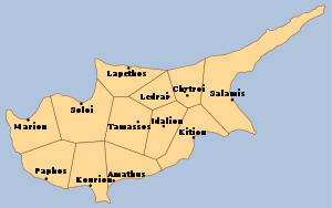
Country:
 Cyprus
Region:
City:
Latitude and Longitude:
Time Zone:
Postal Code:
IP information under different IP Channel
ip-api
Country
Region
City
ASN
Time Zone
ISP
Blacklist
Proxy
Latitude
Longitude
Postal
Route
IPinfo
Country
Region
City
ASN
Time Zone
ISP
Blacklist
Proxy
Latitude
Longitude
Postal
Route
MaxMind
Country
Region
City
ASN
Time Zone
ISP
Blacklist
Proxy
Latitude
Longitude
Postal
Route
Luminati
Country
CYRegion
02
City
limassol
ASN
Time Zone
Asia/Nicosia
ISP
Primetel PLC
Latitude
Longitude
Postal
db-ip
Country
Region
City
ASN
Time Zone
ISP
Blacklist
Proxy
Latitude
Longitude
Postal
Route
ipdata
Country
Region
City
ASN
Time Zone
ISP
Blacklist
Proxy
Latitude
Longitude
Postal
Route
Popular places and events near this IP address
Ledra
Distance: Approx. 193 meters
Latitude and longitude: 35.1625,33.3625
Ledra (Greek: Λήδρα), also spelt Ledrae, was an ancient city-kingdom located in the centre of Cyprus where the capital city of Nicosia is today. Ledra was established in 1050 BC. It became a city-kingdom by the seventh century BC. At times, it had been subject to Assyrian rule. Ledra was one of ten Cypriot kingdoms listed on the prism (many-sided tablet) of the Assyrian king Esarhaddon (680–669 BC).
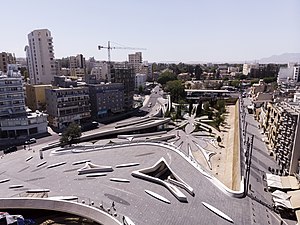
Eleftheria square
Main square in Nicosia, Cyprus.
Distance: Approx. 776 meters
Latitude and longitude: 35.17,33.36
Eleftheria Square (Greek: Πλατεία Ελευθερίας; Turkish: Eleftheria Meydanı, Özgürlük Meydanı); literally meaning Liberty Square, is the main square in central Nicosia, the capital city of Cyprus, in Europe. It forms the intersection of Ledra and Onasagorou streets with Stasinou, Omirou, Kostaki Pantelidi, Konstandinou Palaiologou and Evagorou avenues. It is considered one of Zaha Hadid's Top 35 projects.

Leventis Municipal Museum of Nicosia
Distance: Approx. 783 meters
Latitude and longitude: 35.1706,33.3617
The Leventis Municipal Museum of Nicosia (Greek: Λεβέντιο Μουσείο, Turkish: Leventis Müzesi) in Nicosia, Cyprus, is home to an extensive collection of Cypriot works include archaeological artifacts, costumes, photographs, medieval pottery, maps and engravings, jewels, and furniture.

GSP Stadium (1902)
Football stadium in Nicosia, Cyprus
Distance: Approx. 870 meters
Latitude and longitude: 35.167954,33.355804
GCP Stadium (Greek: Στάδιο Γυμναστικός Σύλλογος "Τα Παγκύπρια") was a football stadium in Nicosia, Cyprus. It had a capacity of 12,000 and was built in 1902 with donations given by Greek Cypriot Nicosians. On 17 October 1934, after a general assembly of the GCP association, the stadium was renamed "GCP Stadium, Eugenia and Antonios Theodotou" in honour of the stadium's major benefactors.
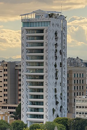
Tower 25
High-rise in Nicosia, Cyprus
Distance: Approx. 617 meters
Latitude and longitude: 35.1686,33.3605
Tower 25, also known as The White Walls, is a high-rise building located in central Nicosia, the capital of Cyprus. Designed by architect Jean Nouvel, it gained recognition as one of Nicosia's notable landmarks due to its distinctive design and central location. Standing at a height of 62 meters, Tower 25 ranks as the eleventh-tallest building in Cyprus.

Solomos Square
Central Bus Station in Nicosia, Cyprus.
Distance: Approx. 893 meters
Latitude and longitude: 35.17055556,33.35861111
Solomos Square (Greek: Πλατεία Σολωμού; Turkish: Solomos Meydanı) is a square at the intersection of Rigenis Street and Omirou Avenue in central Nicosia, Cyprus. It acts as one of the six main bus-hubs of the city, and it is estimated that over 50,000 people pass through it daily. The square was remodelled in 2010, following the initiative of former Mayor Eleni Mavrou.

American International School in Cyprus
Private school in Nicosia, Cyprus
Distance: Approx. 834 meters
Latitude and longitude: 35.15907,33.3568
American International School in Cyprus (AISC) is a private coeducational school in Nicosia, Cyprus. It offers an American and international university preparatory education, including the option of the International Baccalaureate program for the last two years of secondary school. AISC is owned by Esol Education.
Ayios Savvas, Nicosia
Place in Nicosia District, Cyprus
Distance: Approx. 846 meters
Latitude and longitude: 35.17138889,33.36333333
Ayios Savvas is a neighbourhood, quarter, mahalla or parish of Nicosia, Cyprus and the parish church thereof. At the last census (2011) it had a population of 581, an increase from a population of 523 in 2001. It covers 25 streets in the south of Nicosia within the walls.

Leventis Gallery
Art gallery in Nicosia, Cyprus
Distance: Approx. 794 meters
Latitude and longitude: 35.1694,33.3585
The Leventis Gallery is an art gallery in Nicosia, Cyprus. Opened in 2014, it houses a collection of over 800 paintings from Cypriot, Greek and European artists. An International architectural design competition was launched by RIBA Competitions to design the art gallery with restaurant and housing for the A. G. Leventis Foundation, a private foundation supporting educational, cultural and philanthropic causes mainly in Cyprus and Greece and promoting Hellenic culture.

Bayraktar Mosque
Mosque in Nicosia, Cyprus
Distance: Approx. 604 meters
Latitude and longitude: 35.16908,33.36543
Bayraktar Mosque (Turkish: Bayraktar Camisi, Greek: Τέμενος Μπαϊρακτάρ Témenos Mpairaktár) is a mosque in Nicosia, Cyprus, currently placed in the southern sector of the city administered by the Republic of Cyprus.
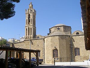
Archangel Michael Trypiotis Church
Cultural property in Nicosia, Cyprus
Distance: Approx. 843 meters
Latitude and longitude: 35.171312,33.362687
The Archangel Michael Trypiotis Church (Greek: Ιερός Ναός Αρχαγγέλου Μιχαήλ Τρυπιώτου) is a Greek Orthodox church in the old town of Nicosia, Cyprus. Although incorporating earlier material, according to the inscription beside the south porch the church is dated to 1695 and it was built at the expense of the Priest Iakovos and Christian parishioners. Important features of the church are the beautiful 18th century iconostasis that was carved by Taliadoros and the icon of Archangel Michael, which dates to 1634.

Agios Georgios Hill, Nicosia
Distance: Approx. 777 meters
Latitude and longitude: 35.16527778,33.35555556
Agios Georgios Hill is an archaeological site in Nicosia, Cyprus. The site is rich and complex, spanning almost the entire history of Nicosia from the Chalcolithic through the Byzantine and Lusignan periods. The surveyed archaeological area is about 650 m2, the whole area measuring 49500 m2.
Weather in this IP's area
few clouds
25 Celsius
25 Celsius
25 Celsius
26 Celsius
1009 hPa
57 %
1009 hPa
991 hPa
10000 meters
8.75 m/s
280 degree
20 %
06:30:17
18:52:35