Country:
 Great Britain
Region:
City:
Latitude and Longitude:
Time Zone:
Postal Code:
IP information under different IP Channel
ip-api
Country
Region
City
ASN
Time Zone
ISP
Blacklist
Proxy
Latitude
Longitude
Postal
Route
IPinfo
Country
Region
City
ASN
Time Zone
ISP
Blacklist
Proxy
Latitude
Longitude
Postal
Route
MaxMind
Country
Region
City
ASN
Time Zone
ISP
Blacklist
Proxy
Latitude
Longitude
Postal
Route
Luminati
Country
GBASN
Time Zone
Europe/London
ISP
EE Limited
Latitude
Longitude
Postal
db-ip
Country
Region
City
ASN
Time Zone
ISP
Blacklist
Proxy
Latitude
Longitude
Postal
Route
ipdata
Country
Region
City
ASN
Time Zone
ISP
Blacklist
Proxy
Latitude
Longitude
Postal
Route
Popular places and events near this IP address

Hatfield, Hertfordshire
Town in Hertfordshire, England
Distance: Approx. 858 meters
Latitude and longitude: 51.76361111,-0.22583333
Hatfield is a town and civil parish in Hertfordshire, England, in the borough of Welwyn Hatfield. It had a population of 29,616 in 2001, 39,201 at the 2011 Census, and 41,265 at the 2021 Census. The settlement is of Saxon origin.

Hatfield railway station
Railway station in Hertfordshire, England
Distance: Approx. 1460 meters
Latitude and longitude: 51.764,-0.216
Hatfield railway station serves the town of Hatfield in Hertfordshire, England. The station is managed by Great Northern. It is 17 miles 54 chains (28.4 km) measured from London King's Cross on the East Coast Main Line.
Hatfield Town F.C.
Association football club in England
Distance: Approx. 1273 meters
Latitude and longitude: 51.774987,-0.22191256
Hatfield Town Football Club is a football club based in Hatfield, Hertfordshire. They are currently members of the Herts County League Premier Division and play at Birchwood Leisure Centre.
Lemsford Road Halt railway station
Former railway station in England
Distance: Approx. 462 meters
Latitude and longitude: 51.7649,-0.2315
Lemsford Road Halt was a railway station on the St Albans Branch of the Great Northern Railway. The platforms are still visible next to the line of the old track, which has been converted to a cycle route and footpath, the Alban Way. The site of the station is located at grid reference TL 220 087 The station was built for the workers of the nearby de Havilland Aircraft factory.

David Lloyd Leisure
UK based health, fitness and racquets group
Distance: Approx. 403 meters
Latitude and longitude: 51.765,-0.24
David Lloyd Leisure Limited, trading as David Lloyd Clubs and commonly known simply as David Lloyd, is a chain of health clubs with its headquarters in the United Kingdom. It is the largest health, fitness and leisure business in Europe by revenue. and operates 130 clubs in nine countries.
Onslow St Audrey's School
Academy in Hatfield, Hertfordshire, England
Distance: Approx. 1377 meters
Latitude and longitude: 51.76019,-0.22053
Onslow St Audrey's School is a co-educational secondary school and sixth form situated in Hatfield, Hertfordshire in England. It specialises in business and enterprise, and is one of only two schools nationally to be awarded British Red Cross School status. Around 550 students attend Onslow St Audrey's.
Bishop's Hatfield Girls' School
Academy in Hatfield, Hertfordshire, England
Distance: Approx. 1206 meters
Latitude and longitude: 51.7589,-0.2263
Bishop's Hatfield Girls' School is a girls' secondary academy school for years 7 to sixth form. It is located in Hatfield, Hertfordshire in Wood's Avenue and was founded in 1960 as a girls' grammar school. The headteacher is Alf Wood.
Hatfield Aerodrome
Airport in Hertfordshire, NE of St Albans
Distance: Approx. 1026 meters
Latitude and longitude: 51.76583333,-0.25083333
Hatfield Aerodrome (IATA: HTF, ICAO: EGTH) was a private airfield and aircraft factory located in the English town of Hatfield in Hertfordshire from 1930 until its closure and redevelopment in the 1990s.

The Galleria, Hatfield
Shopping mall in Hertfordshire, England
Distance: Approx. 800 meters
Latitude and longitude: 51.7611,-0.2405
The Galleria is a designer outlet centre in Hatfield, Hertfordshire in South-East England.

Hatfield Rural District
Rural district in Hertfordshire, England
Distance: Approx. 1145 meters
Latitude and longitude: 51.76537,-0.22014
Hatfield Rural District was a rural district in Hertfordshire, England, from 1894 to 1974, covering an area in the south of the county.

Howe Dell
Distance: Approx. 1528 meters
Latitude and longitude: 51.7572,-0.2222
Howe Dell is a 4 hectare Local Nature Reserve in Hatfield in Hertfordshire. The declaring authority is Welwyn Hatfield Borough Council. The site is woodland which runs along both sides of a stream with steep sides.
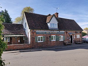
The Wrestlers, Hatfield
Distance: Approx. 1388 meters
Latitude and longitude: 51.77037,-0.21657
The Wrestlers is a public house on the Great North Road in Hatfield, Hertfordshire, England. The Grade II listed building has an eighteenth-century chequered red brick front, but it is based on a sixteenth-century core which preserves some of its timber framing.
Weather in this IP's area
scattered clouds
13 Celsius
13 Celsius
12 Celsius
15 Celsius
1004 hPa
96 %
1004 hPa
995 hPa
10000 meters
1.03 m/s
40 %
06:25:02
19:32:23