Country:
Region:
City:
Latitude and Longitude:
Time Zone:
Postal Code:
IP information under different IP Channel
ip-api
Country
Region
City
ASN
Time Zone
ISP
Blacklist
Proxy
Latitude
Longitude
Postal
Route
Luminati
Country
ASN
Time Zone
Europe/London
ISP
Daisy Corporate Services Trading Ltd
Latitude
Longitude
Postal
IPinfo
Country
Region
City
ASN
Time Zone
ISP
Blacklist
Proxy
Latitude
Longitude
Postal
Route
db-ip
Country
Region
City
ASN
Time Zone
ISP
Blacklist
Proxy
Latitude
Longitude
Postal
Route
ipdata
Country
Region
City
ASN
Time Zone
ISP
Blacklist
Proxy
Latitude
Longitude
Postal
Route
Popular places and events near this IP address

Wellingborough School
Public school in Northamptonshire, England
Distance: Approx. 551 meters
Latitude and longitude: 52.2976,-0.6873
Wellingborough School is a co-educational private day school in the market town of Wellingborough in Northamptonshire. It was established in 1595 and is one of the oldest schools in the country. The school today consists of a Prep school (ages 3–10) Senior school (ages 11–16) and a sixth form (ages 16–18).

Wellingborough railway station
Railway station in Northamptonshire, England
Distance: Approx. 675 meters
Latitude and longitude: 52.304,-0.6764
Wellingborough railway station (formerly Wellingborough Midland Road) is a Grade II listed station located in the market town of Wellingborough in Northamptonshire, England. It lies on the Midland Main Line and is 65 miles (104 km) from London St. Pancras.

Wellingborough Whitworth F.C.
Association football club in England
Distance: Approx. 596 meters
Latitude and longitude: 52.29316389,-0.682225
Wellingborough Whitworth Football Club is an English football club based in Wellingborough, Northamptonshire. The club is currently a member of the Spartan South Midlands League Division One and play at Victoria Mill, London Road. The club is managed by James Mallows.
Wellingborough Town F.C.
Association football club in England
Distance: Approx. 596 meters
Latitude and longitude: 52.29316389,-0.682225
Wellingborough Town F.C. is a football club based in Wellingborough, Northamptonshire, England. They play in the Northern Premier League, Midland Division. The club was formed in 2004 after the previous club bearing the name had folded.

Croyland Abbey, Wellingborough
Distance: Approx. 992 meters
Latitude and longitude: 52.3001,-0.6935
Croyland Abbey is a Grade II-listed manor house (currently used as offices), in Wellingborough, Northamptonshire.

Wellingborough London Road railway station
Former railway station in Northamptonshire, England
Distance: Approx. 1024 meters
Latitude and longitude: 52.289,-0.6789
Wellingborough London Road railway station is a former railway station in Wellingborough, Northamptonshire on a line which connected Peterborough and Northampton.
Wellingborough School (cricket ground)
Distance: Approx. 358 meters
Latitude and longitude: 52.295,-0.6788
The Wellingborough School Ground is a cricket ground which was used by Northamptonshire County Cricket Club in 43 First-class matches for 45 years between 1946 and 1991, and 17 List A games between 1970 and 1991. It is now used predominantly for Women's County Twenty20 Cricket. The Thatched Pavilion which adjoins the ground features, as the last step an incoming batsman takes on the way to the wicket, a paving stone from W. G. Grace's home in Bristol.

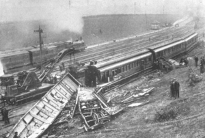
Wellingborough rail accident
Distance: Approx. 644 meters
Latitude and longitude: 52.303,-0.674
On 2 September 1898 at Wellingborough railway station a postman brought a mailcart to the station with mail which he was to see onto a train due at 20:22. The mail should then have been brought to the down platform through a passageway (normally closed by a gate kept locked from the inside) between the station yard and the platform. The postman went into the station, collected a luggage trolley, and took it along the platform to the platform side of the gate.
Wrenn School
School in Wellingborough, Northamptonshire, England
Distance: Approx. 676 meters
Latitude and longitude: 52.2963,-0.6887
Wrenn School is a coeducational secondary comprehensive school and Sixth form with academy status, located in Wellingborough, Northamptonshire, England.
Swansgate Shopping Centre
Shopping centre in Wellingborough, England
Distance: Approx. 897 meters
Latitude and longitude: 52.3012,-0.6915
The Swansgate Shopping Centre is a shopping centre in the town centre of Wellingborough, Northamptonshire, England. It is the second largest shopping centre in Northamptonshire after the Grosvenor Centre in Northampton. It was built in the early 1970s and was originally known as the Arndale Centre.

Church of St Mary the Virgin, Wellingborough
Church in Northamptonshire, England
Distance: Approx. 546 meters
Latitude and longitude: 52.3031,-0.6796
The Church of St Mary the Virgin is a Church of England parish church in Wellingborough, Northamptonshire. The church is a Grade I listed building.

Our Lady of the Sacred Heart Church, Wellingborough
Church in Wellingborough, United Kingdom
Distance: Approx. 573 meters
Latitude and longitude: 52.3025,-0.6839
Our Lady of the Sacred Heart Church is a Roman Catholic parish church in Wellingborough, Northamptonshire, England. It was built from 1884 to 1886 by Samuel Joseph Nicholl in the Gothic Revival style. It is located on Raneleigh Road, between Knox Road and Palk Road to the east of the town centre.
Weather in this IP's area
broken clouds
10 Celsius
9 Celsius
9 Celsius
10 Celsius
1022 hPa
89 %
1022 hPa
1016 hPa
10000 meters
1.82 m/s
1.83 m/s
98 degree
73 %
07:06:13
16:26:24