Country:
 Syria
SyriaRegion:
City:
Latitude and Longitude:
Time Zone:
Postal Code:
IP information under different IP Channel
ip-api
Country
Region
City
ASN
Time Zone
ISP
Blacklist
Proxy
Latitude
Longitude
Postal
Route
IPinfo
Country
Region
City
ASN
Time Zone
ISP
Blacklist
Proxy
Latitude
Longitude
Postal
Route
MaxMind
Country
Region
City
ASN
Time Zone
ISP
Blacklist
Proxy
Latitude
Longitude
Postal
Route
Luminati
Country
SYRegion
di
City
damascus
ASN
Time Zone
Asia/Damascus
ISP
Gruppa Polyplastic LLC
Latitude
Longitude
Postal
db-ip
Country
Region
City
ASN
Time Zone
ISP
Blacklist
Proxy
Latitude
Longitude
Postal
Route
ipdata
Country
Region
City
ASN
Time Zone
ISP
Blacklist
Proxy
Latitude
Longitude
Postal
Route
Popular places and events near this IP address

Damascus
Capital and largest city of Syria
Distance: Approx. 764 meters
Latitude and longitude: 33.51305556,36.29194444
Damascus ( də-MAS-kəs, UK also də-MAH-skəs; Arabic: دِمَشق, romanized: Dimašq) is the capital and largest city of Syria, the oldest current capital in the world and, according to some, the fourth holiest city in Islam. Known colloquially in Syria as aš-Šām (الشَّام) and dubbed, poetically, the "City of Jasmine" (مَدِيْنَةُ الْيَاسْمِينِ Madīnat al-Yāsmīn), Damascus is a major cultural center of the Levant and the Arab world. Situated in southwestern Syria, Damascus is the center of a large metropolitan area.

People's Assembly of Syria
Legislative authority of the Syrian Arab Republic
Distance: Approx. 422 meters
Latitude and longitude: 33.51805556,36.29305556
The People's Assembly (Arabic: مَجْلِس الشَّعْب, ALA-LC: Majlis al-Shaʻb) is Syria's legislative authority. It has 250 members elected for a four-year term in 15 multi-seat constituencies. There are two main political fronts; the National Progressive Front and Popular Front for Change and Liberation.
Commercial Bank of Syria
Banking entity in Syria (1966–present)
Distance: Approx. 639 meters
Latitude and longitude: 33.51611111,36.29444444
The Commercial Bank of Syria (Arabic: المصرف التجاري السوري) is a fully government owned bank in Syria. It is the largest commercial bank in Syria with its headquarters in Damascus. The Commercial Bank accounts for the highest assets share in the banking sector, amounting to 37% of all bank assets at the end of 2017.

Central Bank of Syria
Distance: Approx. 705 meters
Latitude and longitude: 33.52111111,36.29611111
The Central Bank of Syria (CBS; Arabic: مصرف سورية المركزي, romanized: Masrif Suriat Almarkazi) is the central bank of Syria. The bank was established in 1953 and started operations in 1956. Its headquarters are in Damascus, with 11 branches in the provincial capitals.

Four Seasons Hotel Damascus
Syrian luxury hotel
Distance: Approx. 650 meters
Latitude and longitude: 33.51388889,36.29111111
The Four Seasons Hotel Damascus (Arabic: فُنْدُق فَوْر سِيزُون دِمَشْق, romanized: Funduq Fawr Sīzūn Dimašq) is a 297-room five-star hotel and was part of the Toronto-based Four Seasons luxury hotels and resorts from 2005 to June 19, 2019. It is located in the central district neighborhood of Damascus, Syria, near the Barada River, on Shukri Al Quatli Street.
Damascus Community School
Private school in Abu Rummaneh, Syria
Distance: Approx. 657 meters
Latitude and longitude: 33.51722222,36.28222222
Damascus Community School is an unlicensed American school founded by the former US secretary of state John Foster Dulles in 1957 in Damascus, Syria. The school was built to promote American ideals and culture and to help steer Syria away from becoming a Soviet satellite. Since 2012, due to the situation in Syria, the school has been effectively shut down.

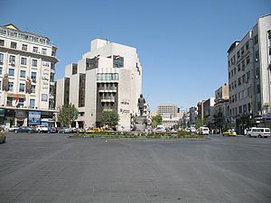
Sabaa Bahrat Square (Damascus)
Main square in Damascus, Syria
Distance: Approx. 678 meters
Latitude and longitude: 33.52055556,36.29597222
Sabaa Bahrat Square (Arabic: ساحة السبع بحرات / ALA-LC: sāḥat as-Saba‘a Baḥrāt; which means "square of the Seven Fountains") is a large and important square in Damascus, Syria. Many important official buildings and ministries are located in the area including the Central Bank of Syria. Many important streets branch from there including Baghdad Street.
Yusuf al-Azma Square
Square in Damascus, Syria
Distance: Approx. 681 meters
Latitude and longitude: 33.51631944,36.29513889
Yusuf al-Azma Square (Arabic: ساحة يوسف العظمة / ALA-LC: sāḥat Yūsuf al-‘Aẓmah), also called al-Muhafaza Square, is an important square in central Damascus, Syria. Named after the late minister of war Yusuf al-Azma where his statue stands in the middle of the square. The municipality of Damascus is located on the square, along with other official and commercial buildings, including Cham Palace Hotel.
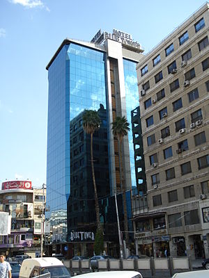
Blue Tower Hotel
Distance: Approx. 148 meters
Latitude and longitude: 33.52027778,36.29
Blue Tower Hotel (Arabic: فُنْدُق بِلُو تَاوْر, romanized: Funduq Bilū Tāwr) is a four-star hotel located on Hamra Street, Damascus, Syria. It has 59 rooms, one restaurant, one café and one bar. The hotel was opened in late 2007.

Abu Rummaneh
Neighborhood in Damascus, Damascus Governorate, Syria
Distance: Approx. 761 meters
Latitude and longitude: 33.52277778,36.28166667
Abu Rummaneh (Arabic: أبو رمانة) is an upscale neighborhood and district of the Muhajirin municipality in western Damascus, Syria. It had a population of 6,421 in the 2004 census.

Sha'alan
Distance: Approx. 181 meters
Latitude and longitude: 33.51777778,36.28861111
Sha'alan (Arabic: الشعلان) is a neighborhood of Damascus, Syria.
Rawda Square
Distance: Approx. 588 meters
Latitude and longitude: 33.52113611,36.28281944
Al-Rawda Square (Arabic: ساحة الروضة / ALA-LC: sāḥat ar-Rawḍah) is a square in north-west Damascus. The square is the location of the National Security Building, where the Defence Minister as well as President Bashar al-Assad’s brother-in-law were assassinated on July 18, 2012 during the Syrian civil war.
Weather in this IP's area
clear sky
31 Celsius
29 Celsius
31 Celsius
31 Celsius
1010 hPa
19 %
1010 hPa
933 hPa
10000 meters
1 m/s
1.32 m/s
86 degree
06:31:59
18:14:10