Country:
 Austria
Region:
City:
Latitude and Longitude:
Time Zone:
Postal Code:
IP information under different IP Channel
ip-api
Country
Region
City
ASN
Time Zone
ISP
Blacklist
Proxy
Latitude
Longitude
Postal
Route
IPinfo
Country
Region
City
ASN
Time Zone
ISP
Blacklist
Proxy
Latitude
Longitude
Postal
Route
MaxMind
Country
Region
City
ASN
Time Zone
ISP
Blacklist
Proxy
Latitude
Longitude
Postal
Route
Luminati
Country
ATRegion
3
City
horn
ASN
Time Zone
Europe/Vienna
ISP
Amt der NOe Landesregierung
Latitude
Longitude
Postal
db-ip
Country
Region
City
ASN
Time Zone
ISP
Blacklist
Proxy
Latitude
Longitude
Postal
Route
ipdata
Country
Region
City
ASN
Time Zone
ISP
Blacklist
Proxy
Latitude
Longitude
Postal
Route
Popular places and events near this IP address

Lower Austria
State of Austria
Distance: Approx. 7262 meters
Latitude and longitude: 48.33333333,15.75
Lower Austria (German: Niederösterreich pronounced [ˈniːdɐˌʔøːstəʁaɪ̯ç] , abbreviated LA or NÖ; Austro-Bavarian: Niedaöstareich; Slovak: Dolné Rakúsko; Czech: Dolní Rakousy) is one of the nine states of Austria, located in the northeastern corner of the country. Major cities are Amstetten, Krems an der Donau, Wiener Neustadt and Sankt Pölten, which has been the capital of Lower Austria since 1986, replacing Vienna, which became a separate state in 1921. With a land area of 19,186 km2 (7,408 sq mi) and a population of 1.699 million people, Lower Austria is the largest and second-most-populous state in Austria (after Vienna).

Göttweig Abbey
Benedictine monastery in Lower Austria
Distance: Approx. 3850 meters
Latitude and longitude: 48.36777778,15.6125
Göttweig Abbey (German: Stift Göttweig) is a Benedictine monastery near Krems in Lower Austria. It was founded in 1083 by Altmann, Bishop of Passau.

Furth bei Göttweig
Place in Lower Austria, Austria
Distance: Approx. 4560 meters
Latitude and longitude: 48.36666667,15.6
Furth bei Göttweig is a town and municipality in the district of Krems-Land in the Austrian state of Lower Austria. The municipality consists of the following populated places: Aigen Furth bei Göttweig Klein-Wien Oberfucha Palt Steinaweg Stift Göttweig.

Paudorf
Place in Lower Austria, Austria
Distance: Approx. 2783 meters
Latitude and longitude: 48.35,15.61666667
Paudorf is a town in the district of Krems-Land in the Austrian state of Lower Austria.

Herzogenburg
Place in Lower Austria, Austria
Distance: Approx. 7402 meters
Latitude and longitude: 48.28333333,15.68333333
Herzogenburg is a town in the district of Sankt Pölten-Land in the Austrian state of Lower Austria.
Inzersdorf-Getzersdorf
Place in Lower Austria, Austria
Distance: Approx. 3494 meters
Latitude and longitude: 48.31666667,15.66666667
Inzersdorf-Getzersdorf is a town in the district of Sankt Pölten-Land in the Austrian state of Lower Austria.

Nußdorf ob der Traisen
Place in Lower Austria, Austria
Distance: Approx. 3117 meters
Latitude and longitude: 48.35333333,15.695
Nußdorf ob der Traisen is a municipality in the district of Sankt Pölten-Land in Lower Austria, Austria.

Statzendorf
Place in Lower Austria, Austria
Distance: Approx. 4433 meters
Latitude and longitude: 48.30805556,15.64083333
Statzendorf is a municipality in the district of Sankt Pölten-Land in Lower Austria, Austria.

Traismauer
Place in Lower Austria, Austria
Distance: Approx. 6700 meters
Latitude and longitude: 48.35,15.74444444
Traismauer is a municipality in the district of Sankt Pölten-Land in Lower Austria, Austria. It was established by the Romans, probably on a location of prior settlements. Some Roman buildings survive to this day.
Wölbling
Place in Lower Austria, Austria
Distance: Approx. 6219 meters
Latitude and longitude: 48.31666667,15.58333333
Wölbling is a municipality in the district of Sankt Pölten-Land in the Austrian state of Lower Austria.
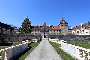
Schloss Walpersdorf
Distance: Approx. 4170 meters
Latitude and longitude: 48.3131,15.6783
Schloss Walpersdorf is a castle in Lower Austria, Austria. Schloss Walpersdorf is 249 metres (817 ft) above sea level.
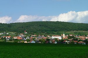
Fugging, Lower Austria
Village in Lower Austria, Austria
Distance: Approx. 6596 meters
Latitude and longitude: 48.29068056,15.62585778
Fugging (German: [ˈfʊɡɪŋ]) is a village in the municipality of Obritzberg-Rust, Sankt Pölten-Land, Austria. It is located in the state of Lower Austria and was known as Fucking until 1836.
Weather in this IP's area
overcast clouds
10 Celsius
9 Celsius
8 Celsius
11 Celsius
1023 hPa
95 %
1023 hPa
983 hPa
10000 meters
1.91 m/s
4.77 m/s
87 degree
99 %
07:23:15
18:01:01