Country:
 Turkey
Region:
City:
Latitude and Longitude:
Time Zone:
Postal Code:
IP information under different IP Channel
ip-api
Country
Region
City
ASN
Time Zone
ISP
Blacklist
Proxy
Latitude
Longitude
Postal
Route
IPinfo
Country
Region
City
ASN
Time Zone
ISP
Blacklist
Proxy
Latitude
Longitude
Postal
Route
MaxMind
Country
Region
City
ASN
Time Zone
ISP
Blacklist
Proxy
Latitude
Longitude
Postal
Route
Luminati
Country
TRASN
Time Zone
Europe/Istanbul
ISP
National Academic Network and Information Center
Latitude
Longitude
Postal
db-ip
Country
Region
City
ASN
Time Zone
ISP
Blacklist
Proxy
Latitude
Longitude
Postal
Route
ipdata
Country
Region
City
ASN
Time Zone
ISP
Blacklist
Proxy
Latitude
Longitude
Postal
Route
Popular places and events near this IP address
Akdeniz University
Public university in Antalya, Turkey
Distance: Approx. 682 meters
Latitude and longitude: 36.895,30.6511
Akdeniz University (Turkish: Akdeniz Üniversitesi) is a public research university established in Antalya, Turkey. It has been chosen as the second most beautiful university in Turkey, after Boğaziçi University. It is one of the leading educational institutions in the country with its Faculty of Medicine, Faculty of Law, and Faculty of Economics and Administrative Sciences.
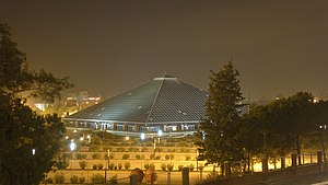
Glass Pyramid Sabancı Congress and Exhibition Center
Distance: Approx. 1424 meters
Latitude and longitude: 36.8845,30.6662
The Glass Pyramid Sabancı Congress and Exhibition Center, mostly abbreviated as Glass Pyramid, (Turkish: Cam Piramit Sabancı Kongre ve Fuar Merkezi) is a multi-purpose convention complex located in Antalya, Turkey. The two floor building consists of five halls, the largest having a 2,400-seat capacity, an open-air 15,000 m2 exhibition area and various other facilities. The center was built by Sabanci Foundation, and its usage rights have been transferred to the Municipality of Antalya.
Atatürk Cultural Center (Antalya)
Multi-purpose convention complex in Antalya, Turkey
Distance: Approx. 1403 meters
Latitude and longitude: 36.8859,30.66846
The Atatürk Cultural Center (Turkish: Atatürk Kültür Merkezi) is a multi-purpose convention complex located in Antalya, Turkey. Inaugurated in 1996, it is owned by the Antalya Culture and Art Foundation (AKSAV). The complex with a total covered area of 9,000 m2 consists of two halls and two foyers for exhibition purposes.

Antalya Stadium
Multi-purpose stadium in Antalya, Turkey
Distance: Approx. 1210 meters
Latitude and longitude: 36.88861111,30.66888889
The Antalya Stadium, officially branded as Corendon Airlines Park for sponsorship reasons, is a multi-purpose stadium in Antalya, Turkey. It is used mostly for football matches, hosting Turkish Süper Lig club Antalyaspor home matches. It has a capacity of nearly 32,537 (all seated) and is totally covered.
Dilek Sabancı Sport Hall
Indoor sporting arena in Antalya, Turkey
Distance: Approx. 1266 meters
Latitude and longitude: 36.8882,30.66928
Dilek Sabancı Sport Hall (Turkish: Dilek Sabancı Spor Salonu) was an indoor sporting arena located in Antalya, Turkey. Owned by the Sabancı Foundation, it was opened on November 3, 2001. The capacity of the arena was 2,500 spectators.
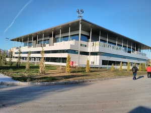
Antalya Sports Hall
Indoor sporting arena in Antalya, Turkey
Distance: Approx. 1516 meters
Latitude and longitude: 36.88869,30.67322
The Antalya Sports Hall is an indoor sporting arena located in Antalya, Turkey. Opened in 2016, the arena has a capacity of 10,000 spectators. It replaced the Dilek Sabancı Spor Salonu as the home of Turkish Basketball League clubs, Antalya Büyükşehir Belediyesi and Kepez Belediyespor.

Arapsu Bridge
Bridge in Antalya, Turkey
Distance: Approx. 1659 meters
Latitude and longitude: 36.880906,30.659346
The Arapsu Bridge is a Roman bridge in Antalya, Turkey. The well-preserved footbridge lies in the Arapsuyu district, 5–6 km west to the city center, at the foot of an ancient mound which is associated with the Greek colony of Olbia. Partly submerged by a modern weir about 100 m downstream, the exact form of its masonry arch is difficult to determine.
Antalya Centennial Archery Field
Archery field located in Antalya, Turkey
Distance: Approx. 1299 meters
Latitude and longitude: 36.88901,30.67057
Antalya Centennial Archery Field (Turkish: Antalya 100. Yıl Okçuluk Sahası) is an archery field in Antalya, Turkey. Situated in the Meltem neighborhood, the archery field on the lawn has the dimensions 140 m × 175 m (459 ft × 574 ft), where 50 targets can be placed.

Akdeniz University Stadium
Distance: Approx. 1075 meters
Latitude and longitude: 36.89361111,30.64694444
Akdeniz University Stadium (Turkish: Akdeniz Üniversitesi Stadyumu) is a multi-use stadium at Akdeniz University, Antalya, on the Mediterranean coast of Turkey. It was home to the Turkish Süper Lig team Antalyaspor between 2012 and 2015.
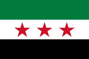
Antalya Conference for Change in Syria
Distance: Approx. 1554 meters
Latitude and longitude: 36.88305556,30.66583333
The Conference for Change in Syria (Turkish: Suriye'de Değişim Konferansı), or Antalya Opposition Conference, was a three-day conference of representatives of the Syrian opposition held from 31 May until 3 June 2011 in Antalya, Turkey. Since the early days of the Syrian civil uprising, it was the second of its kind, following the Istanbul Meeting for Syria that had taken place on 26 April 2011. Organized by Ammar al-Qurabi's National Organization for Human Rights in Syria and financed by the wealthy Damascene Sanqar family, it led to a final statement refusing compromise or reform solutions, and to the election of a 31-member leadership.
Olbia (Pamphylia)
Town on the coast of ancient Pamphylia
Distance: Approx. 1859 meters
Latitude and longitude: 36.879103,30.658713
Olbia (Ancient Greek: Ὀλβία) was the westernmost town on the coast of ancient Pamphylia, which some ancient writers place in Lycia. Ptolemy places it between Phaselis and Attaleia. Stephanus of Byzantium blames Philo for ascribing this town to Pamphylia, since, as he asserts, it was situated in the territory of the Solymi, and its real name was Olba; but the critic is here himself at fault, confounding Olbia with the Pisidian Olbasa.
Tenedos (Pamphylia)
Town on the coast of ancient Pamphylia
Distance: Approx. 1654 meters
Latitude and longitude: 36.8839505,30.6474915
Tenedos (Ancient Greek: Τένεδος) was a fortified coast-town in the west of ancient Pamphylia, 20 stadia to the west of Attalia. Its site is located on the Arab Su, Asiatic Turkey.
Weather in this IP's area
scattered clouds
26 Celsius
27 Celsius
26 Celsius
27 Celsius
1013 hPa
77 %
1013 hPa
1009 hPa
10000 meters
3.6 m/s
180 degree
40 %
07:04:54
18:20:56