194.246.117.211 - IP Lookup: Free IP Address Lookup, Postal Code Lookup, IP Location Lookup, IP ASN, Public IP
Country:
Region:
City:
Location:
Time Zone:
Postal Code:
IP information under different IP Channel
ip-api
Country
Region
City
ASN
Time Zone
ISP
Blacklist
Proxy
Latitude
Longitude
Postal
Route
Luminati
Country
ASN
Time Zone
Europe/Kyiv
ISP
Emplot Ltd.
Latitude
Longitude
Postal
IPinfo
Country
Region
City
ASN
Time Zone
ISP
Blacklist
Proxy
Latitude
Longitude
Postal
Route
IP2Location
194.246.117.211Country
Region
kharkivska oblast
City
kharkiv
Time Zone
Europe/Kiev
ISP
Language
User-Agent
Latitude
Longitude
Postal
db-ip
Country
Region
City
ASN
Time Zone
ISP
Blacklist
Proxy
Latitude
Longitude
Postal
Route
ipdata
Country
Region
City
ASN
Time Zone
ISP
Blacklist
Proxy
Latitude
Longitude
Postal
Route
Popular places and events near this IP address

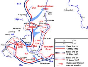
Second Battle of Kharkov
1942 battle in the Eastern Front of World War II
Distance: Approx. 2021 meters
Latitude and longitude: 49.9925,36.23111111
The Second Battle of Kharkov or Operation Fredericus was an Axis counter-offensive in the region around Kharkov against the Red Army Izium bridgehead offensive conducted 12–28 May 1942, on the Eastern Front during World War II. Its objective was to eliminate the Izium bridgehead over Seversky Donets or the "Barvenkovo bulge" (Russian: Барвенковский выступ, romanized: Barvenkovsky vystup) which was one of the Soviet offensive's staging areas. After a winter counter-offensive that drove German troops away from Moscow but depleted the Red Army's reserves, the Kharkov offensive was a new Soviet attempt to expand upon their strategic initiative, although it failed to secure a significant element of surprise. On 12 May 1942, Soviet forces under the command of Marshal Semyon Timoshenko launched an offensive against the German 6th Army from a salient established during the winter counter-offensive.

Metalist Oblast Sports Complex
Multi-use stadium in Kharkiv, Ukraine
Distance: Approx. 644 meters
Latitude and longitude: 49.98085833,36.26170278
"Metalist" Oblast Sports Complex (Ukrainian: Обласний спортивний комплекс "Металіст"), which includes the Metalist Stadium (Ukrainian: Стадіон "Металіст"), is a multi-use stadium in Kharkiv, Ukraine. It is used chiefly for football matches and is the home stadium of FC Metalist 1925 Kharkiv. The stadium, which was a venue for Euro 2012, currently seats 40,003 spectators.

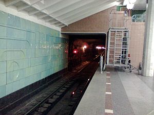
Maidan Konstytutsii (Kharkiv Metro)
Kharkiv Metro station
Distance: Approx. 1865 meters
Latitude and longitude: 49.99138889,36.2325
Maidan Konstytutsii (Ukrainian: Майдан Конституції, - Constitution Square) is a station on the Kharkiv Metro's Kholodnohirsko–Zavodska Line. The station was opened on 23 August 1975. It is located in the historical part of Kharkiv, beneath the Maidan Konstytutsii (Constitution square), previously known as Soviet Square.

Levada (Kharkiv Metro)
Kharkiv Metro station
Distance: Approx. 671 meters
Latitude and longitude: 49.98083333,36.24333333
Levada (Ukrainian: Левада) is a station on the Kharkiv Metro's Kholodnohirsko–Zavodska Line. It opened on 23 August 1975. The station was named Prospekt Haharina (Gagarin Avenue), after Soviet cosmonaut Yuri Gagarin, from 1975 until 2024.

Sportyvna (Kharkiv Metro)
Kharkiv Metro station
Distance: Approx. 601 meters
Latitude and longitude: 49.97944444,36.26083333
Sportyvna (Ukrainian: Спортивна, ) or Sportivnaya (Russian: Спортивная) is a station on the Kharkiv Metro's Kholodnohirsko–Zavodska Line. It was opened on 23 August 1975. It is located in the southwestern part of the city's center, beneath the Plechanivska Vulytsia and the Derzhavinska Vulytsia junction.
Kharkiv Korolenko State Scientific Library
Distance: Approx. 1701 meters
Latitude and longitude: 49.99073611,36.23465
Kharkiv State Scientific Library of Vladimir Korolenko (Ukrainian: Kharkhiv'ska derzhavna naukova biblioteka im. V. G. Korolenka) is the second largest library in Ukraine after the Library of Vernadsky in Kyiv. There are 12 reading rooms for 524 places.

Zakhysnykiv Ukrainy (Kharkiv Metro)
Kharkiv Metro station
Distance: Approx. 1226 meters
Latitude and longitude: 49.98861389,36.264775
Zakhysnykiv Ukrainy (Ukrainian: Захисників України, ) (meaning: Defenders of Ukraine) is a station on the Kharkiv Metro's Oleksiivska Line. The station opened on 6 May 1995. Prior to 17 May 2016, the station's name was Ploshcha Povstannia (Площа Повстання, 'Rebellion Square').

Metrobudivnykiv (Kharkiv Metro)
Kharkiv Metro station
Distance: Approx. 755 meters
Latitude and longitude: 49.97860556,36.26267222
Metrobudivnykiv (Ukrainian: Метробудівників, ), formerly Metrobudivnykiv imeni H. I. Vashchenka (Ukrainian: Метробудівників імені Г.І. Ващенка) is a station on the Kharkiv Metro's Oleksiivska Line. The station opened on 6 May 1995. On 18 May 2016, the station was renamed, conforming with the law banning Communist names in Ukraine.
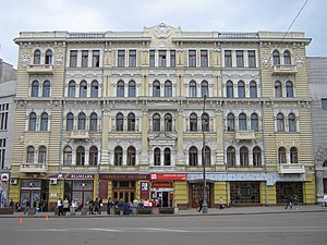
Kharkiv Choral Synagogue
Orthodox synagogue in Kharkiv, Ukraine
Distance: Approx. 1819 meters
Latitude and longitude: 49.99243889,36.23486389
The Kharkiv Choral Synagogue (Ukrainian: Харківська хоральна синагога) is an Orthodox Jewish synagogue, located at 12 Pushkinska Street, Kharkiv, in the Kharkiv Oblast of Ukraine. The Chabad congregation worships in the synagogue, also called Beit Menachem, reportedly the largest synagogue in Ukraine, and a building of architectural significance.

Kharkiv National Academy of Urban Economy
Public university in Kharkiv, Ukraine
Distance: Approx. 1756 meters
Latitude and longitude: 49.995,36.242
Kharkiv National University of Urban Economy (Ukrainian: Харківський національний університет міського господарства, Kharkivskiy natsionalniy universitet mis'koho hospodarstva; before 2013 — academy) is a Ukrainian university in Kharkiv, named after Alexei N. Beketov and specializing in urban development studies.
Kharkiv National Kotlyarevsky University of Arts
Ukrainian music and theatre university
Distance: Approx. 1875 meters
Latitude and longitude: 49.991139,36.232028
Kharkiv National University of Arts named after I. P. Kotlyarevsky (or Kharkiv Conservatory or Kharkiv National I. P. Kotlyarevsky University of Arts; Ukrainian: Харківський національний університет мистецтв ім. І. П. Котляревського) is the leading music and drama institution of higher education in Ukraine. The university trains about 900 undergraduates, graduates and postgraduates in music and theatre art.

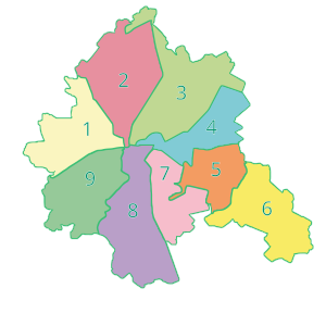
Osnovianskyi District
Urban district in Kharkiv in Kharkiv Oblast, Ukraine
Distance: Approx. 1428 meters
Latitude and longitude: 49.98305556,36.23305556
Osnovianskyi District (Ukrainian: Основ'янський район) is an urban district of the city of Kharkiv, Ukraine, named after a neighborhood in the city Osnova. The district was established in January 1919 as Petynsko-Zhuravlivskyi. In September 1924, it was renamed Chervonozavodskyi.
Weather in this IP's area
overcast clouds
4 Celsius
2 Celsius
4 Celsius
4 Celsius
1030 hPa
77 %
1030 hPa
1016 hPa
10000 meters
2.51 m/s
4.44 m/s
31 degree
100 %


