Country:
 Great Britain
Region:
City:
Latitude and Longitude:
Time Zone:
Postal Code:
IP information under different IP Channel
ip-api
Country
Region
City
ASN
Time Zone
ISP
Blacklist
Proxy
Latitude
Longitude
Postal
Route
IPinfo
Country
Region
City
ASN
Time Zone
ISP
Blacklist
Proxy
Latitude
Longitude
Postal
Route
MaxMind
Country
Region
City
ASN
Time Zone
ISP
Blacklist
Proxy
Latitude
Longitude
Postal
Route
Luminati
Country
GBASN
Time Zone
Europe/London
ISP
CW Vodafone Group PLC
Latitude
Longitude
Postal
db-ip
Country
Region
City
ASN
Time Zone
ISP
Blacklist
Proxy
Latitude
Longitude
Postal
Route
ipdata
Country
Region
City
ASN
Time Zone
ISP
Blacklist
Proxy
Latitude
Longitude
Postal
Route
Popular places and events near this IP address
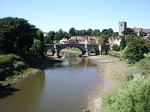
Aylesford
Human settlement in England
Distance: Approx. 1471 meters
Latitude and longitude: 51.3033,0.4796
Aylesford is a village and civil parish on the River Medway in Kent, England, 4 miles (6 km) northwest of Maidstone. Originally a small riverside settlement, the old village comprises around 60 houses, many of which were formerly shops. Two pubs, a village shop and other amenities are located on the high street.

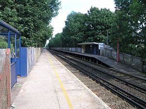
Barming railway station
Railway station serving the Borough of Tonbridge & Malling
Distance: Approx. 997 meters
Latitude and longitude: 51.285,0.479
Barming railway station is located in Tonbridge and Malling Borough, west of Maidstone in Kent, England, and approximately 1 mile from Barming and Maidstone Hospital. It is 37 miles 43 chains (60.4 km) down the line from London Victoria. The station and all trains serving it are operated by Southeastern.

Aylesford railway station
Railway station in Kent, England
Distance: Approx. 1104 meters
Latitude and longitude: 51.30138889,0.46611111
Aylesford railway station is on the Medway Valley Line in Kent, England, serving the village of Aylesford. It is 38 miles 74 chains (62.6 km) down the line from London Charing Cross via Strood and is situated between New Hythe and Maidstone Barracks. The station opened on 18 June 1856.

Ditton, Kent
Human settlement in England
Distance: Approx. 1274 meters
Latitude and longitude: 51.29485,0.4519
Ditton is a large village and civil parish in the borough of Tonbridge and Malling in Kent, England. The village is 4.6 miles (7.4 km) west-northwest of Maidstone and 1.8 miles (2.9 km) east of West Malling. The parish, which is long and narrow, straddles the A20 (the old Dover to London road), with farmland to the south and industry to the north.

Allington Quarry Waste Management Facility
Waste management centre in Allington, Kent
Distance: Approx. 1516 meters
Latitude and longitude: 51.2928,0.4912
The Allington Quarry Waste Management Facility is an integrated waste management centre in Allington, Kent. It is the site of the Allington Energy from Waste (EfW) Incinerator. The incinerator is owned by FCC Environment as Kent Enviropower.

Aylesford School (Kent)
Academy in Aylesford, Kent, England
Distance: Approx. 891 meters
Latitude and longitude: 51.2992,0.465
Aylesford School is a mixed-sex school comprising years 7 to 11, plus a Sixth Form for pupils in years 12 and 13. It was formerly known as Aylesford School - Sports College and locally known as Teapot Lane, is a co-educational secondary school in Kent, England. Situated in modern campus buildings in Teapot Lane, the school serves an area to the west of Maidstone.

Preston Hall, Aylesford
Distance: Approx. 639 meters
Latitude and longitude: 51.295,0.477
Preston Hall is a former manorial home and associated estate in Aylesford in the English county of Kent. It dates to the Norman period and was owned by the Culpepper family for over 400 years. Part of the estate became the Royal British Legion Village in the 1920s and the hall itself was used as a hospital after World War II. The estate was broken up over a period of time and most of the area it once covered is now used for housing.

Aylesford Priory
Monastery in Kent, England
Distance: Approx. 1240 meters
Latitude and longitude: 51.30277778,0.47138889
Aylesford Priory, or "The Friars" was founded in 1242 when members of the Carmelite order arrived in England from Mount Carmel in the Holy Land. Richard de Grey, a crusader, sponsored them, and conveyed to the order a parcel of land located on his manor in Aylesford in Kent. The estate came back into the ownership of the Carmelite order in 1949.

Ditton Quarry
Park in Kent, United Kingdom
Distance: Approx. 804 meters
Latitude and longitude: 51.291,0.458
Ditton Quarry is a 5.6-hectare (14-acre) Local Nature Reserve in Ditton, on the north-western outskirts of Maidstone in Kent. It is owned and managed by Ditton Parish Council. This former quarry has grassland and scrub, with diverse fauna including butterflies, foxes, rabbits, frogs, toads and newts.
East Malling and Larkfield
Civil parish in Kent, England
Distance: Approx. 216 meters
Latitude and longitude: 51.29,0.471
East Malling is a civil parish in Kent which includes the villages of East Malling and Larkfield. In 2011 it had a population of 14,185.

Maidstone and Malling (UK Parliament constituency)
Parliamentary constituency in the United Kingdom, 2024 onwards
Distance: Approx. 193 meters
Latitude and longitude: 51.29,0.47
Maidstone and Malling is a constituency of the House of Commons in the UK Parliament. It was created under the 2023 Periodic Review of Westminster constituencies, and was first contested in the 2024 general election.
Finnish Olympic Sauna
Historic sauna in Aylesford, England
Distance: Approx. 1563 meters
Latitude and longitude: 51.3015,0.4534
The Finnish Sauna Bath London 1948, also known in the British context as the Finnish Olympic Sauna or the Cobdown Sauna (after its current location), is a sauna facility located in Cobdown Park, Aylesford, Kent, England. It was built by the Finnish timber building supplier Puutalo for use by the athletes and other members of the Finnish team at the London 1948 Olympics, in line with Finland's tradition of building 'Olympic saunas' for its athletes' use going back to the Paris 1924 games. The sauna was originally located in the athletes' village in Richmond Park, London, from where it was moved to the Reed Paper Mill in Aylesford a year later, and eventually from there to its current location nearby in 1957.
Weather in this IP's area
broken clouds
15 Celsius
14 Celsius
14 Celsius
16 Celsius
1005 hPa
75 %
1005 hPa
1002 hPa
10000 meters
1.34 m/s
133 degree
83 %
06:22:45
19:29:02