Country:
Region:
City:
Latitude and Longitude:
Time Zone:
Postal Code:
IP information under different IP Channel
ip-api
Country
Region
City
ASN
Time Zone
ISP
Blacklist
Proxy
Latitude
Longitude
Postal
Route
Luminati
Country
Region
8
City
feldkirch
ASN
Time Zone
Europe/Vienna
ISP
Kabel-TV Lampert GmbH & Co KG
Latitude
Longitude
Postal
IPinfo
Country
Region
City
ASN
Time Zone
ISP
Blacklist
Proxy
Latitude
Longitude
Postal
Route
db-ip
Country
Region
City
ASN
Time Zone
ISP
Blacklist
Proxy
Latitude
Longitude
Postal
Route
ipdata
Country
Region
City
ASN
Time Zone
ISP
Blacklist
Proxy
Latitude
Longitude
Postal
Route
Popular places and events near this IP address

Battle of Frastanz
Battle during the Swabian War
Distance: Approx. 1892 meters
Latitude and longitude: 47.22,9.62
The Battle of Frastanz between an army of the Old Swiss Confederacy and the troops of King Maximilian I of the Holy Roman Empire took place on 20 April 1499. In one of the many raids of the Swabian War, an expedition of Habsburg troops had plundered some villages in the Swiss Confederacy, who responded by sending an army to Vorarlberg. At Frastanz, a few kilometers south-east of Feldkirch, the Habsburg troops had blocked the entry to the Montafon valley with a strong wooden fortification called a Letzi.

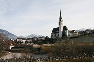
Frastanz
Place in Vorarlberg, Austria
Distance: Approx. 1892 meters
Latitude and longitude: 47.22,9.62
Frastanz is a market town in the district of Feldkirch in the westernmost Austrian state of Vorarlberg. In former times it was known for its production of tobacco.

Samina (river)
River of Liechtenstein and Austria
Distance: Approx. 1108 meters
Latitude and longitude: 47.2253,9.627
The Samina (also: Saminabach) is a whitewater river of Liechtenstein and Austria. It is a tributary of the Ill. The Samina originates in Liechtenstein.

Schattenburg
Castle, museum and restaurant in Feldkirch, Vorarlberg, Austria
Distance: Approx. 3021 meters
Latitude and longitude: 47.23638889,9.59944444
Schattenburg is a castle, museum, and restaurant in Feldkirch, Vorarlberg (Austria). Schattenburg is 480 metres (1,570 ft) above sea level.[1]. Its name is assumedly derived from the word stem "schatte, schad" meaning "protection, shield".

Satteins
Place in Vorarlberg, Austria
Distance: Approx. 2669 meters
Latitude and longitude: 47.21666667,9.66666667
Satteins is a town in the Austrian state of Vorarlberg.

Göfis
Place in Vorarlberg, Austria
Distance: Approx. 469 meters
Latitude and longitude: 47.23305556,9.63305556
Göfis is a municipality in the district of Feldkirch in the Austrian state of Vorarlberg.
Übersaxen
Place in Vorarlberg, Austria
Distance: Approx. 2967 meters
Latitude and longitude: 47.25,9.66666667
Übersaxen is a municipality in the district of Feldkirch in the Austrian state of Vorarlberg.

Feldkirch railway station
Railway station in Vorarlberg, Austria
Distance: Approx. 2829 meters
Latitude and longitude: 47.24111111,9.60416667
Feldkirch railway station (German: Bahnhof Feldkirch) serves the city of Feldkirch, in the Feldkirch district of the Austrian federal state of Vorarlberg. Opened in 1872, it forms the junction between the Vorarlberg railway and the Feldkirch–Buchs railway. The station, which is owned and operated by the Austrian Federal Railways (ÖBB), is the largest in Feldkirch.

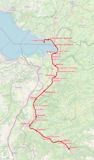
Vorarlberg Railway
Railway line in Austria and Germany
Distance: Approx. 1247 meters
Latitude and longitude: 47.2201,9.6392
The Vorarlberg Railway (German: Vorarlbergbahn) denotes a railway line running in north-south direction through the Austrian state of Vorarlberg and extending to Lindau (Germany). Its route is similar to the Rheintal/Walgau Autobahn, from Lindau to the border and to Bludenz, where it connects to the Arlberg Railway and Bludenz–Schruns railway (Montafonerbahn) lines. The entire route in Austria is owned and is operated up to Lindau-Insel by the Austrian Federal Railways (Österreichische Bundesbahnen, ÖBB).
Feldkirch Sickhouse
Building in Feldkirch, Austria
Distance: Approx. 2855 meters
Latitude and longitude: 47.249945,9.612752
Feldkirch Sickhouse (Siechenhaus), Feldkirch, Vorarlberg, Austria, is listed an Austrian monument of cultural significance. The group of two buildings was erected in the late 16th or early 17th century. Far outside the city of Feldkirch a leper house was founded in the 14th century.
Frastanz railway station
Railway station in Vorarlberg, Austria
Distance: Approx. 1273 meters
Latitude and longitude: 47.219861,9.638661
Frastanz railway station (German: Bahnhof Frastanz) is a railway station in Frastanz in the Feldkirch district of the Austrian federal state of Vorarlberg. It was opened on 1 July 1872, together with the rest of the Vorarlberg railway. The station is owned and operated by the Austrian Federal Railways (ÖBB).
Feldkirch Amberg railway station
Railway station in Vorarlberg, Austria
Distance: Approx. 3007 meters
Latitude and longitude: 47.255728,9.621711
Feldkirch Amberg railway station (German: Bahnhof Feldkirch-Amberg) is a railway station in the Levis district of the town of Feldkirch in the Feldkirch district of the Austrian federal state of Vorarlberg. It is located near the Amberg Castle (Schloss Amberg) and owned and operated by the Austrian Federal Railways (ÖBB). The station was opened on 1 July 1872, together with the rest of the Vorarlberg railway.
Weather in this IP's area
few clouds
1 Celsius
1 Celsius
0 Celsius
2 Celsius
1028 hPa
86 %
1028 hPa
961 hPa
10000 meters
0.5 m/s
0.81 m/s
158 degree
11 %
07:25:57
16:46:28


