194.208.13.248 - IP Lookup: Free IP Address Lookup, Postal Code Lookup, IP Location Lookup, IP ASN, Public IP
Country:
 Austria
Region:
City:
Location:
Time Zone:
Postal Code:
ISP:
ASN:
language:
User-Agent:
Proxy IP:
Blacklist:
IP information under different IP Channel
ip-api
Country
Region
City
ASN
Time Zone
ISP
Blacklist
Proxy
Latitude
Longitude
Postal
Route
db-ip
Country
Region
City
ASN
Time Zone
ISP
Blacklist
Proxy
Latitude
Longitude
Postal
Route
IPinfo
Country
Region
City
ASN
Time Zone
ISP
Blacklist
Proxy
Latitude
Longitude
Postal
Route
IP2Location
194.208.13.248Country
atRegion
tirol
City
sankt anton am arlberg
Time Zone
Europe/Vienna
ISP
Language
User-Agent
Latitude
Longitude
Postal
ipdata
Country
Region
City
ASN
Time Zone
ISP
Blacklist
Proxy
Latitude
Longitude
Postal
Route
Popular places and events near this IP address

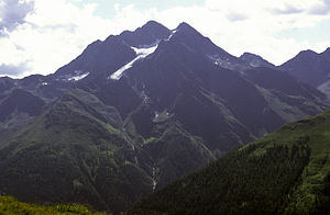
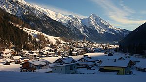
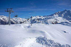
St Anton am Arlberg
Municipality in Tyrol, Austria
Distance: Approx. 1227 meters
Latitude and longitude: 47.11666667,10.26666667
Sankt Anton am Arlberg, commonly referred to as St Anton, is a village and ski resort in the Austrian state of Tyrol. It lies in the Tyrolean Alps, with aerial tramways and chairlifts up to 2,811 m (9,222 ft), yielding a vertical drop of 1,507 m (4,944 ft). It is also a popular summer resort among trekkers and mountaineers.

Arlberg
Massif in Austria
Distance: Approx. 4001 meters
Latitude and longitude: 47.13,10.211
The Arlberg (German: [ˈaʁlˌbɛʁk] , also: Arlberg Pass) is a mountain pass between states of Tyrol and Vorarlberg in Austria. Ski resorts at the Arlberg include Lech, Zürs, Stuben, St. Christoph, St.
Verwall Alps
Range of the Alps in Tyrol and Vorarlberg, Austria
Distance: Approx. 8234 meters
Latitude and longitude: 47.11611111,10.37111111
The Verwall Alps or Verwall Group are a mountain range of the Central Eastern Alps at the border of the Austrian states of Tyrol and Vorarlberg. It includes the following peaks (sorted by height): Hoher Riffler 3,168 metres (10,394 feet) Kuchenspitze 3,148 metres (10,401 feet) Küchlspitze 3,147 metres (10,315 feet) Patteriol 3,059 metres (10,037 feet) Saumspitze 3,039 metres (9,970 feet) Scheibler 2,978 metres (9,770 feet) Gaisspitze 2,779 metres (9,117 feet) For a list of passes, see Passes of the Silvretta and Rätikon Ranges The Verwall Alps border on the Silvretta Alps in the west and on the Samnaun Alps in the south.
Pettneu am Arlberg
Municipality in Tyrol, Austria
Distance: Approx. 6343 meters
Latitude and longitude: 47.14833333,10.34166667
Pettneu am Arlberg is a municipality in the district of Landeck in the Austrian state of Tyrol. It is located 16.3 km west of the city of Landeck. The location was first mentioned in 1300 as Ponte novu (nou) which means new bridge.
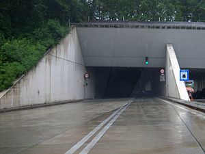
Arlberg Road Tunnel
Architectural structure
Distance: Approx. 4051 meters
Latitude and longitude: 47.141172,10.313269
The Arlberg Road Tunnel (German: Arlberg Straßentunnel), with a length of 13.976 kilometres (8.684 mi), is Austria's longest road tunnel. When it was inaugurated, it was the longest road tunnel in the world. It carries the S16 Arlberg Schnellstraße (German for "Arlberg Highway") under the Arlberg massif from Tyrol to Vorarlberg.

Arlberg Railway Tunnel
Railway tunnel in Austria
Distance: Approx. 5920 meters
Latitude and longitude: 47.12861111,10.18555556
The Arlberg Railway Tunnel (German: Arlbergtunnel) forms the central part of the Arlberg railway in western Austria, running between the federal states Tyrol and Vorarlberg. It traverses through the Arlberg massif at the northeastern end of the Rhaetian Alps. First opened to traffic in 1884, it was a major engineering achievement of the nation, being the longest railway tunnel in Austria for over 100 years, possessing a length of 10,216 metres (6.348 mi).

St. Anton am Arlberg railway station
Railway station in Tyrol, Austria
Distance: Approx. 852 meters
Latitude and longitude: 47.1225,10.27222222
St. Anton am Arlberg railway station (German: Bahnhof St. Anton am Arlberg) is a railway station in the village of St Anton am Arlberg in the Austrian state of Tyrol.

Galzig
Distance: Approx. 3128 meters
Latitude and longitude: 47.135,10.22388889
Galzig is a mountain in the Lechtal Alps of Tyrol, Austria. The elevation at its peak is 2,184 metres (7,165 ft). Located near St.
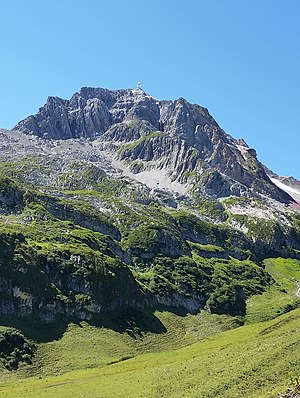
Valluga
Mountain in the Lechtal Alps, Austria
Distance: Approx. 5085 meters
Latitude and longitude: 47.1575,10.21305556
Valluga is a 2,811 m (AA) high mountain in the Lechtal Alps. The border between the Austrian states Tyrol and Vorarlberg runs over the summit. It is about 3 km north of the village St.
Ski Arlberg
Ski area in Austria
Distance: Approx. 5085 meters
Latitude and longitude: 47.1575,10.21305556
The Ski Arlberg ski area is situated in the Arlberg massif in the states of Vorarlberg and Tyrol (Austria). Since the winter of 2013–14, the villages of Lech, Oberlech, Zürs and Zug have been linked to the Warth-Schröcken ski area which makes Ski Arlberg the largest connected ski area in Austria.

Stuben am Arlberg
Winter sports resort in Klösterle, Vorarlberg, Austria
Distance: Approx. 7976 meters
Latitude and longitude: 47.13888889,10.15972222
Stuben am Arlberg is a winter sports resort in the town of Klösterle in the westernmost Austrian province of Vorarlberg. It is located at an altitude of 1,410 meters and had 90 inhabitants (as of 1 January 2019).

Karl-Schranz-Piste
Austrian ski course
Distance: Approx. 1292 meters
Latitude and longitude: 47.116,10.266
Karl-Schranz-Piste is a World Cup speed ski course in St Anton am Arlberg, Austria.
Weather in this IP's area
clear sky
3 Celsius
3 Celsius
3 Celsius
3 Celsius
1035 hPa
44 %
1035 hPa
802 hPa
10000 meters
0.82 m/s
0.92 m/s
63 degree
4 %