194.208.116.146 - IP Lookup: Free IP Address Lookup, Postal Code Lookup, IP Location Lookup, IP ASN, Public IP
Country:
 Austria
Region:
City:
Location:
Time Zone:
Postal Code:
ISP:
ASN:
language:
User-Agent:
Proxy IP:
Blacklist:
IP information under different IP Channel
ip-api
Country
Region
City
ASN
Time Zone
ISP
Blacklist
Proxy
Latitude
Longitude
Postal
Route
db-ip
Country
Region
City
ASN
Time Zone
ISP
Blacklist
Proxy
Latitude
Longitude
Postal
Route
IPinfo
Country
Region
City
ASN
Time Zone
ISP
Blacklist
Proxy
Latitude
Longitude
Postal
Route
IP2Location
194.208.116.146Country
atRegion
vorarlberg
City
reuthe
Time Zone
Europe/Vienna
ISP
Language
User-Agent
Latitude
Longitude
Postal
ipdata
Country
Region
City
ASN
Time Zone
ISP
Blacklist
Proxy
Latitude
Longitude
Postal
Route
Popular places and events near this IP address

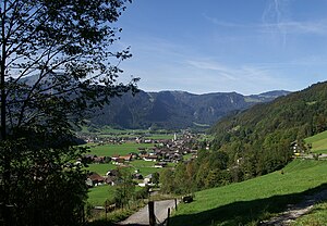
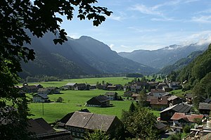
Reuthe
Municipality in Vorarlberg, Austria
Distance: Approx. 222 meters
Latitude and longitude: 47.37,9.89333333
Reuthe is a municipality of the Bregenzerwald, in the westernmost Austrian state of Vorarlberg. It is located in the district of Bregenz. Its main industry is tourism.

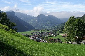
Mellau
Municipality in Vorarlberg, Austria
Distance: Approx. 2219 meters
Latitude and longitude: 47.35111111,9.88194444
Mellau is a town in the Bregenz Forest in the westernmost Austrian state of Vorarlberg, part of the district of Bregenz.
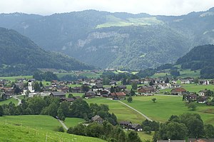
Bezau
Municipality in Vorarlberg, Austria
Distance: Approx. 1854 meters
Latitude and longitude: 47.385,9.90166667
Bezau is a town in the Bregenz Forest region, in the western Austrian state of Vorarlberg. It is part of the district of Bregenz. Bezau is a popular tourist destination around the year, due to its vicinity to ski resorts and hiking trails.
Bizau
Municipality in Vorarlberg, Austria
Distance: Approx. 2487 meters
Latitude and longitude: 47.36888889,9.92333333
Bizau is a town in the Bregenz Forest in the Austrian state of Vorarlberg, part of the district Bregenz. The municipality has around 1080 inhabitants.
Schwarzenberg, Austria
Municipality in Vorarlberg, Austria
Distance: Approx. 6002 meters
Latitude and longitude: 47.41666667,9.85
Schwarzenberg is a municipality in the Bregenz Forest in the western Austrian state of Vorarlberg, part of the district of Bregenz. Schwarzenberg has an area of 25.76 km². It lies south of Lake Constance.
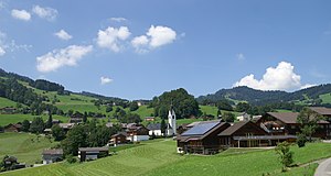
Andelsbuch
Municipality in Vorarlberg, Austria
Distance: Approx. 4821 meters
Latitude and longitude: 47.41333333,9.89611111
Andelsbuch is a municipality in the district of Bregenz in the Austrian state of Vorarlberg.
Schnepfau
Municipality in Vorarlberg, Austria
Distance: Approx. 3942 meters
Latitude and longitude: 47.35,9.93333333
Schnepfau is a municipality in the district of Bregenz in the Austrian state of Vorarlberg.
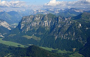
Kanisfluh
Distance: Approx. 5099 meters
Latitude and longitude: 47.33166667,9.92694444
The Kanisfluh is a mostly isolated massif in the central Bregenz Forest Mountains between the municipalities Mellau and Au.The Kanisfluh is considered the most famous mountain and landmark of the Bregenz Forest, Vorarlberg, Austria.

Bolgenach
River in Germany
Distance: Approx. 2811 meters
Latitude and longitude: 47.355031,9.9202
Bolgenach is a river of Bavaria, Germany and Vorarlberg, Austria. It flows into the Weißach near Krumbach.

Bregenz Forest Railway
Distance: Approx. 1370 meters
Latitude and longitude: 47.38194444,9.89583333
The Bregenz Forest Railway (German: Bregenzerwaldbahn, known colloquially as the Wälderbahn or Wälderbähnle), is an Austrian narrow gauge railway with a track gauge of 760 mm (2 ft 5+15⁄16 in), the so-called Bosnian gauge. It runs through the state of Vorarlberg and from 1902 to 1983 linked Bregenz on Lake Constance with Bezau in the Bregenz Forest on a 35.33 kilometre long railway line. Today only a 5.01 kilometre long section is still worked as a heritage railway.

Damülser Mittagsspitze
Mountain in Vorarlberg, Austria
Distance: Approx. 6599 meters
Latitude and longitude: 47.31111111,9.88333333
Damülser Mittagsspitze is a 2,095 m (AA) high mountain in the Bregenz Forest Mountains in the Austrian state Vorarlberg.

Angelika Kauffmann Museum
Museum in Austria of the Swiss painter Angelica Kauffman.
Distance: Approx. 5877 meters
Latitude and longitude: 47.4158,9.8511
The Angelika Kauffmann Museum is a museum in Schwarzenberg, Vorarlberg (Austria) dedicated to the life and works of the Swiss painter Angelica Kauffman. Although born in Chur in Switzerland, Angelica Kauffman had close ties to her father's home village of Schwarzenberg. Together, they worked for the local bishop, creating apostle frescoes and the high altarpiece.
Weather in this IP's area
clear sky
-3 Celsius
-7 Celsius
-4 Celsius
-2 Celsius
1036 hPa
96 %
1036 hPa
905 hPa
10000 meters
2.38 m/s
1.59 m/s
133 degree
1 %