Country:
Region:
City:
Latitude and Longitude:
Time Zone:
Postal Code:
IP information under different IP Channel
ip-api
Country
Region
City
ASN
Time Zone
ISP
Blacklist
Proxy
Latitude
Longitude
Postal
Route
Luminati
Country
ASN
Time Zone
Europe/Moscow
ISP
Voin Telecom LLC
Latitude
Longitude
Postal
IPinfo
Country
Region
City
ASN
Time Zone
ISP
Blacklist
Proxy
Latitude
Longitude
Postal
Route
db-ip
Country
Region
City
ASN
Time Zone
ISP
Blacklist
Proxy
Latitude
Longitude
Postal
Route
ipdata
Country
Region
City
ASN
Time Zone
ISP
Blacklist
Proxy
Latitude
Longitude
Postal
Route
Popular places and events near this IP address

Arctic and Antarctic Research Institute
Russian research institute
Distance: Approx. 889 meters
Latitude and longitude: 59.94652778,30.23333333
The Arctic and Antarctic Research Institute, or AARI (Russian: Арктический и антарктический научно-исследовательский институт, romanized: Arkticheskiy i antarkticheskiy nauchno-issledovatelskiy institut, abbreviated as ААНИИ) is the oldest and largest Russian research institute in the field of comprehensive studies of Arctic and Antarctica. It is located in Saint Petersburg. The AARI has numerous departments, such as those of oceanography, glaciology, meteorology, hydrology or Arctic river mouths and water resources, geophysics, polar geography, and others.

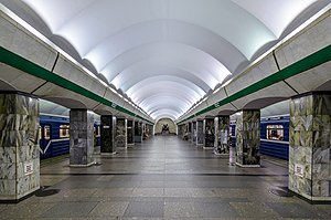
Primorskaya (Saint Petersburg Metro)
Saint Petersburg Metro Station
Distance: Approx. 726 meters
Latitude and longitude: 59.94888889,30.23277778
Primorskaya (Russian: Примо́рская) is the station of the Nevsko–Vasileostrovskaya Line (Line 3) of the Saint Petersburg Metro. It was designed by V.N. Sokolov, M.I. Starodubov and V.A. Penno and opened on 28 September 1979. The opening of the station, situated in the western part of Vasilievsky Island, was designed to coincide with the expansion of the local neighborhoods.
Vasileostrovsky District
District in federal city of St. Petersburg, Russia
Distance: Approx. 996 meters
Latitude and longitude: 59.94388889,30.24166667
Vasileostrovsky District (Russian: Василеостро́вский райо́н) is a district of the federal city of St. Petersburg, Russia. As of the 2010 Census, its population was 214,625; down from 236,856 recorded in the 2002 Census.

Dekabristov Island
Island in Russia
Distance: Approx. 632 meters
Latitude and longitude: 59.95,30.23333333
Dekabristov Island (Russian: остров Декабристов, lit. 'Decembrists Island'), known prior to 1926 as Goloday Island (остров Голодай – possibly a corruption of a British merchant name Halliday) is an island in Vasileostrovsky District of Saint Petersburg, Russia, to the north of Vasilyevsky Island, separated from it by Smolenka River. The island, originally low-lying and frequently flooded, all the same was traditionally used as the Smolensky Lutheran Cemetery. In the early Soviet period, the name was changed to Decembrists' Island to commemorate five executed leaders of Decembrist revolt, who were buried in an unmarked grave on Goloday.
Smolensky Lutheran Cemetery
Cemetery in St. Petersburg, Russia
Distance: Approx. 491 meters
Latitude and longitude: 59.95,30.25
The Smolenskoye(-oe) Cemetery (in German Smolensker Friedhof) is a Lutheran cemetery on Dekabristov Island in Saint Petersburg, Russia. It is one of the largest and oldest non-orthodox cemeteries in the city. Until the early 20th century it was one of the main burial grounds for ethnic Germans.

Petrovsky Island
Distance: Approx. 1449 meters
Latitude and longitude: 59.959444,30.265556
Petrovsky Island (Russian: Петро́вский о́стров) is an island in St. Petersburg, Russia, bordered by the Malaya Neva, Malaya Nevka, and Zhdanovka Rivers (in the delta of the Neva River).

St. Petersburg River Yacht Club
Distance: Approx. 1269 meters
Latitude and longitude: 59.96416667,30.24138889
The St. Petersburg River Yacht Club, also known as St. Petersburg Central River Yacht Club or simply Central River Yacht Club, is a sailing club in Saint Petersburg.

Smolensky Cemetery
Cemetery in Saint Petersburg, Russia
Distance: Approx. 1096 meters
Latitude and longitude: 59.94333333,30.24861111
Smolensky Cemetery (Russian: Смоленское кладбище) is the oldest continuously operating cemetery in Saint Petersburg, Russia. It occupies a rectangular parcel in the western part of Vasilievsky Island, on the bank of the small Smolenka River, and is divided into the Orthodox, Lutheran, and Armenian sections.
Deutsche Schule Sankt Petersburg
German international school in Russia
Distance: Approx. 964 meters
Latitude and longitude: 59.9519,30.2604
Deutsche Schule Sankt Petersburg (DSP) is a German international school in St. Petersburg, Russia. As of 2010 it servedlevels Vorschule (preschool) through grade 10, with plans to expand to grade 12 and the Abitur.

Artmuza
Art museum in Saint Petersburg, RU
Distance: Approx. 1458 meters
Latitude and longitude: 59.94555556,30.265
Artmuza is a contemporary art gallery and a creative space in Saint Petersburg on Vasilievsky Island in Russia. Since 2013, it has been at the location of the former factory of musical instruments "Muzdetal".

Betancourt Bridge
Bridge in Saint Petersburg, Russia
Distance: Approx. 1335 meters
Latitude and longitude: 59.9573,30.2654
Betancourt Bridge (Russian: Мост Бетанку́ра, Most Betankura) is a non-bascule 6-lane bridge with a cycle path in Saint Petersburg that opened in 2018. The bridge crosses the Little Neva and the Zhdanovka rivers, passing Petrovsky and Sernyy island, and connects the Vasilyevsky and Petrogradsky islands. The bridge is part of the Centre Transport Bypass (CTB), it allows non-stop traffic from Pulkovo Airport to the Krestovsky Stadium.

Ostrov Dekabristov Municipal Okrug
Municipal okrug in St. Petersburg, Russia
Distance: Approx. 457 meters
Latitude and longitude: 59.95277778,30.235
Ostrov Dekabristov Municipal Okrug (Russian: муниципа́льный о́круг Остров Декабристов) is a municipal okrug in Vasileostrovsky District, one of the eighty-one low-level municipal divisions of the federal city of St. Petersburg, Russia. As of the 2010 Census, its population was 60,842, up from 53,882 recorded during the 2002 Census.
Weather in this IP's area
broken clouds
4 Celsius
-0 Celsius
4 Celsius
4 Celsius
983 hPa
87 %
983 hPa
981 hPa
10000 meters
7 m/s
190 degree
75 %
09:04:46
16:24:02
