194.183.61.172 - IP Lookup: Free IP Address Lookup, Postal Code Lookup, IP Location Lookup, IP ASN, Public IP
Country:
Region:
City:
Location:
Time Zone:
Postal Code:
IP information under different IP Channel
ip-api
Country
Region
City
ASN
Time Zone
ISP
Blacklist
Proxy
Latitude
Longitude
Postal
Route
Luminati
Country
Region
18
City
krosno
ASN
Time Zone
Europe/Warsaw
ISP
Krosnienskie Centrum Informatyczne KROSOFT
Latitude
Longitude
Postal
IPinfo
Country
Region
City
ASN
Time Zone
ISP
Blacklist
Proxy
Latitude
Longitude
Postal
Route
IP2Location
194.183.61.172Country
Region
wielkopolskie
City
krosno
Time Zone
Europe/Warsaw
ISP
Language
User-Agent
Latitude
Longitude
Postal
db-ip
Country
Region
City
ASN
Time Zone
ISP
Blacklist
Proxy
Latitude
Longitude
Postal
Route
ipdata
Country
Region
City
ASN
Time Zone
ISP
Blacklist
Proxy
Latitude
Longitude
Postal
Route
Popular places and events near this IP address

Mosina
Town in Wielkopolska Province, Poland
Distance: Approx. 2705 meters
Latitude and longitude: 52.24666667,16.845
Mosina [mɔˈɕina] is a town in Poznań County, Greater Poland Voivodeship, Poland, 21 km south of Poznań, with 12,107 inhabitants (2004). The Mosiński Canal runs east and west through the town, and joins the Warta River just to the east.
Gmina Mosina
Gmina in Greater Poland Voivodeship, Poland
Distance: Approx. 2705 meters
Latitude and longitude: 52.24666667,16.845
Gmina Mosina is an urban-rural gmina (administrative district) in Poznań County, Greater Poland Voivodeship, in west-central Poland. Its seat is the town of Mosina, which lies approximately 18 kilometres (11 mi) south of the regional capital Poznań. The gmina covers an area of 170.87 square kilometres (66.0 sq mi), and as of 2006 its total population is 25,098 (out of which the population of Mosina amounts to 12,150, and the population of the rural part of the gmina is 12,948).
Bogulin
Settlement in Greater Poland Voivodeship, Poland
Distance: Approx. 2621 meters
Latitude and longitude: 52.22194444,16.87083333
Bogulin [bɔˈɡulin] is a settlement in the administrative district of Gmina Mosina, within Poznań County, Greater Poland Voivodeship, in west-central Poland.
Borkowice, Greater Poland Voivodeship
Village in Greater Poland Voivodeship, Poland
Distance: Approx. 2347 meters
Latitude and longitude: 52.21666667,16.8
Borkowice [bɔrkɔˈvit͡sɛ] is a village in the administrative district of Gmina Mosina, within Poznań County, Greater Poland Voivodeship, in west-central Poland. It lies approximately 5 kilometres (3 mi) south-west of Mosina and 22 km (14 mi) south of the regional capital Poznań. The village has an approximate population of 204.
Drużyna, Greater Poland Voivodeship
Village in Greater Poland Voivodeship, Poland
Distance: Approx. 1481 meters
Latitude and longitude: 52.21083333,16.82638889
Drużyna [druˈʐɨna] is a village in the administrative district of Gmina Mosina, within Poznań County, Greater Poland Voivodeship, in west-central Poland. It lies approximately 5 kilometres (3 mi) south of Mosina and 22 km (14 mi) south of the regional capital Poznań.
Krosinko, Greater Poland Voivodeship
Village in Greater Poland Voivodeship, Poland
Distance: Approx. 2939 meters
Latitude and longitude: 52.25,16.83333333
Krosinko [krɔˈɕinkɔ] is a village in the administrative district of Gmina Mosina, within Poznań County, Greater Poland Voivodeship, in west-central Poland. It lies approximately 18 kilometres (11 mi) south of the regional capital Poznań.

Krosno, Poznań County
Village in Greater Poland Voivodeship, Poland
Distance: Approx. 1085 meters
Latitude and longitude: 52.23333333,16.83333333
Krosno [ˈkrɔsnɔ] is a village in the administrative district of Gmina Mosina, within Poznań County, Greater Poland Voivodeship, in west-central Poland. It lies approximately 2 kilometres (1 mi) south-west of Mosina and 20 km (12 mi) south of the regional capital Poznań.

Ludwikowo, Gmina Mosina
Village in Greater Poland Voivodeship, Poland
Distance: Approx. 2682 meters
Latitude and longitude: 52.24444444,16.81277778
Ludwikowo [ludviˈkɔvɔ] is a village in the administrative district of Gmina Mosina, within Poznań County, Greater Poland Voivodeship, in west-central Poland.
Nowinki, Greater Poland Voivodeship
Village in Greater Poland Voivodeship, Poland
Distance: Approx. 774 meters
Latitude and longitude: 52.21666667,16.83333333
Nowinki [nɔˈvinki] is a village in the administrative district of Gmina Mosina, within Poznań County, Greater Poland Voivodeship, in west-central Poland. It lies approximately 4 kilometres (2 mi) south of Mosina and 22 km (14 mi) south of the regional capital Poznań.

Sowiniec, Greater Poland Voivodeship
Village in Greater Poland Voivodeship, Poland
Distance: Approx. 3659 meters
Latitude and longitude: 52.23888889,16.88
Sowiniec [sɔˈviɲɛt͡s] is a village in the administrative district of Gmina Mosina, within Poznań County, Greater Poland Voivodeship, in west-central Poland.

Stare Dymaczewo
Village in Greater Poland Voivodeship, Poland
Distance: Approx. 3713 meters
Latitude and longitude: 52.22944444,16.77888889
Stare Dymaczewo [ˈstarɛ dɨmaˈt͡ʂɛvɔ] is a village in the administrative district of Gmina Mosina, within Poznań County, Greater Poland Voivodeship, in west-central Poland.

Voivodeship road 430
Road in Poland
Distance: Approx. 3568 meters
Latitude and longitude: 52.253743,16.850272
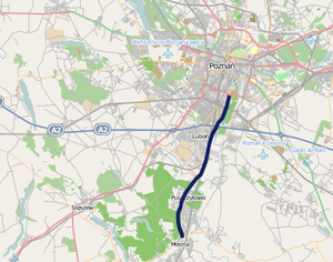
Voivodeship road 430 (Polish: Droga wojewódzka nr 430, abbreviated DW 430) is a route in the Polish voivodeship roads network. It runs through the Greater Poland Voivodeship (Poznań County), leading from Poznań, through Luboń and Puszczykowo to Mosina where it meets Voivodeship road 431.
Weather in this IP's area
overcast clouds
-3 Celsius
-8 Celsius
-3 Celsius
-2 Celsius
1034 hPa
88 %
1034 hPa
1024 hPa
10000 meters
5.09 m/s
12.34 m/s
232 degree
94 %