194.182.149.85 - IP Lookup: Free IP Address Lookup, Postal Code Lookup, IP Location Lookup, IP ASN, Public IP
Country:
Region:
City:
Location:
Time Zone:
Postal Code:
IP information under different IP Channel
ip-api
Country
Region
City
ASN
Time Zone
ISP
Blacklist
Proxy
Latitude
Longitude
Postal
Route
Luminati
Country
ASN
Time Zone
Europe/Copenhagen
ISP
TDC Holding A/S
Latitude
Longitude
Postal
IPinfo
Country
Region
City
ASN
Time Zone
ISP
Blacklist
Proxy
Latitude
Longitude
Postal
Route
IP2Location
194.182.149.85Country
Region
midtjylland
City
tranbjerg
Time Zone
Europe/Copenhagen
ISP
Language
User-Agent
Latitude
Longitude
Postal
db-ip
Country
Region
City
ASN
Time Zone
ISP
Blacklist
Proxy
Latitude
Longitude
Postal
Route
ipdata
Country
Region
City
ASN
Time Zone
ISP
Blacklist
Proxy
Latitude
Longitude
Postal
Route
Popular places and events near this IP address
Hasselhøj
Distance: Approx. 2645 meters
Latitude and longitude: 56.112155,10.103269
Hasselhøj is a residential area built in 1984, located in peaceful surroundings in Hasselager south of Aarhus, Denmark. Its postal code is 8361.

Mårslet
Town in Midtjylland, Denmark
Distance: Approx. 3582 meters
Latitude and longitude: 56.06805556,10.16111111
Mårslet is a railway town in Denmark, located about 11 km (6.8 mi) south of Aarhus. It has a population of 5,146 (1 January 2024). Mårslet is located in Aarhus Municipality and therefore is part of the Central Denmark Region.
Rosenhøj
Neighborhood in Aarhus Municipality, Central Denmark Region, Kingdom of Denmark
Distance: Approx. 3268 meters
Latitude and longitude: 56.11484,10.147426
Rosenhøj (lit.: Rose-hill) is a public housing project in Viby J, a southern district of Aarhus, Denmark. Rosenhøj consists of concrete apartment blocks, with a total of 808 rentals, built in 1967-70. The area underwent a thorough renovation in the years 2014-17, updating the buildings to contemporary climate regulations, and also adding 22 new rowhouse rentals and outdoor sports facilities among other improvements.
Slet, Aarhus
Suburb of Aarhus, Denmark
Distance: Approx. 2102 meters
Latitude and longitude: 56.103407,10.143121
Slet is a suburb of Aarhus in Denmark, roughly 5 kilometers south of the city, between Holme and Tranbjerg. The town that would later become Slet was created in 1682.

Tranbjerg J
Neighborhood in Aarhus Municipality, Central Denmark Region, Denmark
Distance: Approx. 3807 meters
Latitude and longitude: 56.06,10.09
Tranbjerg J is a town in Aarhus in Denmark. "J" is for Jutland to distinguish this place from a similarly named place on Zealand, and is not used in daily parlance.

Testrup Højskole
School
Distance: Approx. 2743 meters
Latitude and longitude: 56.06706944,10.13480556
Testrup Højskole (English: Testrup Folk High School) is a Danish Folk High School based on the philosophy of N. F. S. Grundtvig. It was founded in 1866 by theologist Jens Nørregård. The School is situated south of Aarhus in the small rural town of Testrup and offers curriculums in five subjects: music, drama, art, philosophy, and creative writing.

INCUBA Science Park
Distance: Approx. 2822 meters
Latitude and longitude: 56.11369,10.102471
INCUBA Science Park is a research park in Aarhus, Denmark with four departments in Skejby, Katrinebjerg, Aarhus University and Aarhus Docklands. INCUBA was created as a merger of three former research institutions in 2007, and is an amalgamation of "Innovation Network Centre for University and Businesses of Aarhus" and the primary goals of the institution are to strengthen cooperation between research institutions and companies with consultancy and by raising capital for projects. The park is the first of its kind in Denmark.

Aarhus Academy
Secondary school in Aarhus, Denmark
Distance: Approx. 1776 meters
Latitude and longitude: 56.105858,10.114617
The Aarhus Academy (Danish: Århus Akademi) is a school of secondary education in Aarhus, Denmark. The school offers the 2 year Higher Preparatory Examination (HF) programme, the 2 year Matriculation examination (STX) programme and supplementary courses in specific disciplines. Aarhus Academy is located in the neighborhood of Christiansbjerg in the city district of Aarhus N. The academy was founded in 1933 by Svend Orhammer Andersen as a public elementary school which also offered a 2-year Matriculation examination programme for older students.

VUC Aarhus
Secondary school in Aarhus, Denmark
Distance: Approx. 1776 meters
Latitude and longitude: 56.105858,10.114617
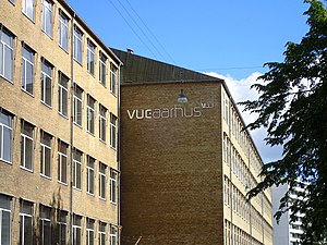
VUC Aarhus (short for Voksen Uddannelses Center Aarhus) is a school of secondary education in Aarhus, Denmark. The school offers the 2 year Higher Preparatory Examination (HF) programme and supplementary courses (GSK) to the Matriculation examination (STX) within a range of disciplines. The school has since 2007 been an independent self-owning educational institution under the supervision of the state, managed by a board in conjunction with a principal who manages the day-to-day operations.

SOSU Aarhus
Distance: Approx. 1776 meters
Latitude and longitude: 56.105858,10.114617
SOSU Østjylland (formerly SOSU Aarhus and previously Social og Sundhedsskolen Aarhus) is a school of secondary education in Aarhus, Denmark. The school provides vocational training and educational programmes within the health sciences. SOSU Østjylland is an independent self-owning educational institution under the supervision of the state, managed by a board in conjunction with a principal who manages the day-to-day operations.

Tranbjerg Church
Church in Denmark, Denmark
Distance: Approx. 1001 meters
Latitude and longitude: 56.0919,10.1349
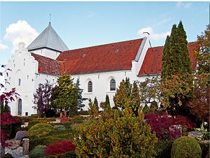
Tranbjerg Church is a church in Aarhus, Denmark, situated in the suburb Tranbjerg 9 kilometers south-west of Aarhus city center on the old country road between Aarhus and Horsens. Tranbjerg Church is from the 1100s, erected as a typical Danish Romanesque village church. Later additions in the 15th century added a Gothic tower and porch.
Kolt Church
Church in Aarhus, Denmark
Distance: Approx. 3692 meters
Latitude and longitude: 56.109343,10.070669
Kolt Church (Danish: Kolt Kirke) is a church located in Kolt Parish in Aarhus, Denmark. The church is situated in the Hasselager neighborhood, south-west of Viby. It is a parish church of the Church of Denmark and there's population of 6.973 within the parish borders (2016).
Weather in this IP's area
overcast clouds
4 Celsius
1 Celsius
4 Celsius
4 Celsius
1021 hPa
90 %
1021 hPa
1015 hPa
10000 meters
4.72 m/s
11.52 m/s
208 degree
93 %
