194.182.146.174 - IP Lookup: Free IP Address Lookup, Postal Code Lookup, IP Location Lookup, IP ASN, Public IP
Country:
Region:
City:
Location:
Time Zone:
Postal Code:
IP information under different IP Channel
ip-api
Country
Region
City
ASN
Time Zone
ISP
Blacklist
Proxy
Latitude
Longitude
Postal
Route
Luminati
Country
ASN
Time Zone
Europe/Copenhagen
ISP
TDC Holding A/S
Latitude
Longitude
Postal
IPinfo
Country
Region
City
ASN
Time Zone
ISP
Blacklist
Proxy
Latitude
Longitude
Postal
Route
IP2Location
194.182.146.174Country
Region
sjaelland
City
ringsted
Time Zone
Europe/Copenhagen
ISP
Language
User-Agent
Latitude
Longitude
Postal
db-ip
Country
Region
City
ASN
Time Zone
ISP
Blacklist
Proxy
Latitude
Longitude
Postal
Route
ipdata
Country
Region
City
ASN
Time Zone
ISP
Blacklist
Proxy
Latitude
Longitude
Postal
Route
Popular places and events near this IP address

Zealand
Most populous island of Denmark
Distance: Approx. 6872 meters
Latitude and longitude: 55.5,11.75
Zealand (Danish: Sjælland [ˈɕeˌlænˀ]) is the largest and most populous island in Denmark proper (thus excluding Greenland and Disko Island, which are larger in size) at 7,031 km2. Zealand had a population of 2,319,705 on 1 January 2020, comprising 40% of the country's population. Zealand is the 13th-largest island in Europe by area and the 4th most populous.

Ringsted
City in Zealand, Denmark
Distance: Approx. 13 meters
Latitude and longitude: 55.4425,11.79
Ringsted is a city located centrally in the Danish island of Zealand. It is the seat of a municipality of the same name. Ringsted is situated approximately 60 km (37 mi) from Copenhagen.

Ringsted Municipality
Municipality in Zealand, Denmark
Distance: Approx. 307 meters
Latitude and longitude: 55.445276,11.788908
Ringsted Municipality (Danish: Ringsted Kommune) is a kommune in the Region Sjælland on the island of Zealand in east Denmark. The municipality covers an area of 295 km2, and has a total population of 36,356 (2024). Its mayor is Henrik Hvidesten, a member of Venstre.

Ortved
Distance: Approx. 5904 meters
Latitude and longitude: 55.48333333,11.85
Ortved is a small village with a population of only 245 (1 January 2024) in Ringsted Municipality in the central part of the island of Zealand, Denmark, and is a part of region Sjælland. It lies on Roskildevejen main road close to the city of Ringsted. Ortved is also the village with Denmark's 5th most popular camping.
Ringsted-Hallen
Distance: Approx. 856 meters
Latitude and longitude: 55.4475,11.80055556
Ringsted-Hallen is an indoor sports arena in Ringsted, Denmark primarily used for handball. The arena was built in 1997 and holds 1,600 spectators (approx. 600 seated).

Copenhagen–Fredericia/Taulov Line
Railway line in Denmark
Distance: Approx. 8446 meters
Latitude and longitude: 55.4593,11.9206
The Copenhagen–Fredericia/Taulov Line is the Danish railway line between the capital, Copenhagen, and the Jutland peninsula by way of the islands of Zealand and Funen. It is administered by Banedanmark and has a length of about 220 kilometres (140 mi). Being one of the main arteries of the Danish railway network, it has double track and is fully electrified.

Ringsted Abbey
Benedictine monastery in Denmark
Distance: Approx. 351 meters
Latitude and longitude: 55.4451,11.7867
Ringsted Abbey (Ringsted Kloster) was one of the earliest and most influential Benedictine houses in Denmark, active from the late 11th-century until the Danish Reformation. It was located at Ringsted on the Danish island of Zealand.
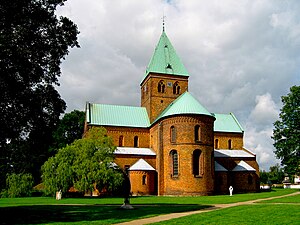
St. Bendt's Church, Ringsted
Church building in Ringsted Municipality, Denmark
Distance: Approx. 426 meters
Latitude and longitude: 55.446,11.787
St. Bendt's Church (Danish: Sankt Bendts Kirke) is a church in Ringsted, Denmark, which was originally part of a Benedictine monastery that burnt down in the 18th century. Built in the Romanesque style, it is the oldest brick church in Scandinavia, dating back to about 1170 when it replaced a travertine church from about 1080.
Rosengaard
Danish manor house
Distance: Approx. 5983 meters
Latitude and longitude: 55.46138889,11.87888889
Rosengaard is a manor house and estate in Ringsted Municipality, Denmark.
Mørup
Manor house near Sorø, Denmark
Distance: Approx. 7581 meters
Latitude and longitude: 55.45472222,11.67194444
Mørup is a manor house and estate located close to Sorø, Denmark. It is now owned by Sorø Academy The half-timbered main building dates from the beginning of the 19th century.

Sørup, Ringsted Municipality
Manor house near Rinsted, Denmark
Distance: Approx. 6295 meters
Latitude and longitude: 55.38611111,11.79472222
Sørup is a manor house and estate located 6 kilometres south of Ringsted, Denmark. The current Historicist main building was constructed after a fire in 1909. It is now operated as a hotel and conference centre.

Ringsted railway station
Railway station in Ringsted Municipality, Denmark
Distance: Approx. 558 meters
Latitude and longitude: 55.43805556,11.78638889
Ringsted railway station (Danish: Ringsted Station or Ringsted Banegård) is a railway station serving the town of Ringsted in central Zealand, Denmark. It is located in the centre of the town, on the southern edge of the historic town centre, and immediately adjacent to the Ringsted bus station. Ringsted station is an important railway junction where the main line Copenhagen–Fredericia, Copenhagen–Ringsted, and South Line railway lines all meet.
Weather in this IP's area
clear sky
6 Celsius
1 Celsius
5 Celsius
6 Celsius
1007 hPa
70 %
1007 hPa
1002 hPa
10000 meters
8.79 m/s
15.02 m/s
288 degree
7 %
