Country:
 Netherlands
Region:
City:
Latitude and Longitude:
Time Zone:
Postal Code:
IP information under different IP Channel
ip-api
Country
Region
City
ASN
Time Zone
ISP
Blacklist
Proxy
Latitude
Longitude
Postal
Route
IPinfo
Country
Region
City
ASN
Time Zone
ISP
Blacklist
Proxy
Latitude
Longitude
Postal
Route
MaxMind
Country
Region
City
ASN
Time Zone
ISP
Blacklist
Proxy
Latitude
Longitude
Postal
Route
Luminati
Country
NLASN
Time Zone
Europe/Amsterdam
ISP
BIT BV
Latitude
Longitude
Postal
db-ip
Country
Region
City
ASN
Time Zone
ISP
Blacklist
Proxy
Latitude
Longitude
Postal
Route
ipdata
Country
Region
City
ASN
Time Zone
ISP
Blacklist
Proxy
Latitude
Longitude
Postal
Route
Popular places and events near this IP address
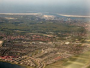
Velsen
Municipality in North Holland, Netherlands
Distance: Approx. 2517 meters
Latitude and longitude: 52.46666667,4.61666667
Velsen (Dutch pronunciation: [ˈvɛlzə(n)] ) is a municipality in the Netherlands, in the province of North Holland. It is located on both sides of the North Sea Canal. On the north side of the North Sea Canal there is a major steel plant, Tata Steel IJmuiden, formerly known as Koninklijke Hoogovens (the town of IJmuiden is actually located south of the canal).

IJmuiden
City in North Holland, Netherlands
Distance: Approx. 2281 meters
Latitude and longitude: 52.45861111,4.61944444
IJmuiden (Dutch pronunciation: [ɛiˈmœydə(n)]) is a port city in the Dutch province of North Holland. It is the main town in the municipality of Velsen which lies mainly to the south-east. Including its large sea locks, it straddles the mouth of the North Sea Canal to Amsterdam.

North Sea Canal
Dutch ship canal
Distance: Approx. 2297 meters
Latitude and longitude: 52.46388889,4.55833333
The North Sea Canal (Dutch: Noordzeekanaal) is a Dutch ship canal from Amsterdam to the North Sea at IJmuiden, constructed between 1865 and 1876 to enable seafaring vessels to reach the port of Amsterdam. This man-made channel terminates at Amsterdam in the closed-off IJ Bay, which in turn connects to the Amsterdam-Rhine Canal. The drainage of the canal to the North Sea is done through the IJmuiden sea lock, augmented by the largest pumping station in Europe.

Dance Valley
Distance: Approx. 3039 meters
Latitude and longitude: 52.4308288,4.6132296
Dance Valley ("The Woodstock of Dance") is an annual dance music festival organised by United Dance Company (UDC) in the summer in Spaarnwoude, Netherlands. The first edition was in 1995 when 8,000 people attended (and in 2001 90,000 visitors). Dance Valley grew rapidly, both in duration and number of visitors.

Tata Steel Netherlands
Former Dutch steel company
Distance: Approx. 2847 meters
Latitude and longitude: 52.47839,4.59212
Koninklijke Hoogovens known as Koninklijke Nederlandse Hoogovens en Staalfabrieken (KNHS) until 1996 or informally Hoogovens. is a Dutch steel producer founded in 1918. Since 2010, the plant is named Tata Steel IJmuiden.

IJmuider Zee- en Havenmuseum
Distance: Approx. 921 meters
Latitude and longitude: 52.4574,4.5986
The IJmuider Zee- en Havenmuseum is a museum located at the start of the Vissershaven in IJmuiden, the Netherlands, dedicated to promoting interest and conserving the fishing and shipping cultural heritage of IJmuiden and the North Sea Canal.

Hoge vuurtoren van IJmuiden
Lighthouse
Distance: Approx. 920 meters
Latitude and longitude: 52.46083333,4.58277778
The hoge vuurtoren van IJmuiden ("high lighthouse of IJmuiden") is a round, cast-iron lighthouse in IJmuiden, Netherlands, designed by Quirinus Harder. It was built in 1878 by D.A. Schretlen & Co, a company in Leiden. Together with the Lage vuurtoren van IJmuiden, the 35-meter high lighthouse forms a pair of leading lights marking the IJgeul (the entrance on the North Sea to the North Sea Canal).

Lage vuurtoren van IJmuiden
Lighthouse
Distance: Approx. 1298 meters
Latitude and longitude: 52.46183333,4.57461111
The Lage vuurtoren van IJmuiden ("low lighthouse of IJmuiden") is a round, cast-iron lighthouse in IJmuiden, Netherlands, designed by Quirinus Harder. It was built in 1878 by D.A. Schretlen & Co, a company in Leiden and activated the following year. In 1909, the top three sections were moved to Vlieland where they serve as a separate lighthouse.
Mekog
Distance: Approx. 3153 meters
Latitude and longitude: 52.475809,4.614658
Mekog (Maatschappij tot Exploitatie van Kooksovengas, English coke oven gas exploitation company) was a chemical company founded 1928, that manufactured fertilizer using hydrogen from coke oven gas as a feedstock. The company's facilities were located on the site of the Koninklijke Nederlandsche Hoogovens en Staalfabrieken steelworks near IJmuiden in the Netherlands.
Imko's
Restaurant in IJmuiden, Netherlands
Distance: Approx. 892 meters
Latitude and longitude: 52.45968889,4.59433056
Restaurant Imko's is a defunct restaurant in IJmuiden, Netherlands. It was a fine dining restaurant that was awarded one Michelin star in 1999 and retained that rating until 2003. Due to deterioration of the port area where the restaurant started suffering.
IJmuiden sea lock
Water navigation device serving Port of Amsterdam
Distance: Approx. 2299 meters
Latitude and longitude: 52.466358,4.612942
The IJmuiden sea lock (Dutch: zeesluis IJmuiden) serving Port of Amsterdam via the North Sea Canal is the largest lock in the world when considering dimensions. The lock, situated in IJmuiden in the municipality of Velsen, was opened on 26 January 2022 in the presence of King Willem-Alexander of the Netherlands. The locks of IJmuiden have a history dating back to 1876, when the largest lock of that era was opened.

Fort IJmuiden
Distance: Approx. 1536 meters
Latitude and longitude: 52.465401,4.577185
Fort IJmuiden is a former fort, now heritage site and event location in IJmuiden North-Holland. It protected the entrance to the North Sea Canal. The fort was originally located north of the canal, but by the construction of a new branch, it became an island.
Weather in this IP's area
light rain
14 Celsius
14 Celsius
14 Celsius
15 Celsius
1013 hPa
96 %
1013 hPa
1012 hPa
10000 meters
2.63 m/s
2.77 m/s
228 degree
86 %
08:12:41
18:40:28