194.164.236.3 - IP Lookup: Free IP Address Lookup, Postal Code Lookup, IP Location Lookup, IP ASN, Public IP
Country:
Region:
City:
Location:
Time Zone:
Postal Code:
ISP:
ASN:
language:
User-Agent:
Proxy IP:
Blacklist:
IP information under different IP Channel
ip-api
Country
Region
City
ASN
Time Zone
ISP
Blacklist
Proxy
Latitude
Longitude
Postal
Route
db-ip
Country
Region
City
ASN
Time Zone
ISP
Blacklist
Proxy
Latitude
Longitude
Postal
Route
IPinfo
Country
Region
City
ASN
Time Zone
ISP
Blacklist
Proxy
Latitude
Longitude
Postal
Route
IP2Location
194.164.236.3Country
Region
agder
City
arendal
Time Zone
Europe/Oslo
ISP
Language
User-Agent
Latitude
Longitude
Postal
ipdata
Country
Region
City
ASN
Time Zone
ISP
Blacklist
Proxy
Latitude
Longitude
Postal
Route
Popular places and events near this IP address
Arendal
Municipality in Agder, Norway
Distance: Approx. 360 meters
Latitude and longitude: 58.46083333,8.76638889
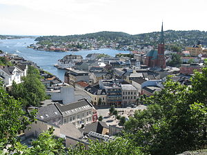
Arendal (Urban East Norwegian pronunciation: [ˈɑ̂ːɳɖɑːɫ] ) is a municipality in Agder county in southeastern Norway. Arendal belongs to the region of Sørlandet. The administrative centre of the municipality is the city of Arendal (which is also the seat of Agder county).
Barbu, Norway
Former municipality in Aust-Agder, Norway
Distance: Approx. 627 meters
Latitude and longitude: 58.46638889,8.77805556
Barbu is a former municipality in the old Aust-Agder county in Norway. Today, it is part of the is part of the town of Arendal in Agder county. The 15.3-square-kilometre (5.9 sq mi) municipality existed from 1878 until 1902 when it was merged into the town of Arendal.

Grimstad Line
Railway line in Norway
Distance: Approx. 402 meters
Latitude and longitude: 58.4649,8.7696
The Grimstad Line (Norwegian: Grimstadbanen) was a 22-kilometer (14 mi) long railway line between Grimstad and Rise in Norway. The line was a branch of the Arendal Line, which is in turn a branch of the Sørland Line. Opened as the Grimstad–Froland Line on 14 September 1907, it was originally a private railway.
Arendal station
Railway station in Arendal, Norway
Distance: Approx. 375 meters
Latitude and longitude: 58.46472222,8.77
Arendal Station (Norwegian: Arendal stasjon) is the terminus railway station of the Arendal Line, located in Arendal, Norway. The station opened on 23 November 1908 and is served by the Go-Ahead Norge.
Arendal Town Hall
Distance: Approx. 456 meters
Latitude and longitude: 58.46044783,8.76487778
Arendal Town hall (Norwegian: Arendal rådhus og kulturhus) is located in the middle of downtown Arendal, Norway. The building's two theater halls have been given names from the two lighthouses outside Arendal, Store Torungen Lighthouse and Lille Torungen Lighthouse. Central to the building is a large hall, and surrounding this hall are communal offices.
Trinity Church (Arendal)
Church in Agder, Norway
Distance: Approx. 469 meters
Latitude and longitude: 58.459215,8.765762
Trinity Church (Norwegian: Trefoldighetskirken) is a parish church of the Church of Norway in Arendal Municipality in Agder county, Norway. It is located in the central part of the town of Arendal. It is the church for the Trefoldighet parish.

Aust-Agder County Municipality
Former County in Norway
Distance: Approx. 443 meters
Latitude and longitude: 58.4644,8.767
Aust-Agder County Municipality (Norwegian: Aust-Agder fylkeskommune) was the regional governing administration of the old Aust-Agder county in Norway. The county municipality was established on 1 January 1976 when the law was changed to allow elected county councils in Norway. The county municipality was dissolved on 1 January 2020, when Aust-Agder was merged with the neighboring Vest-Agder county, creating the new Agder county which is led by the Agder County Municipality.
Arendal Airport, Rådhuskaien
Airport in Rådhuskaien, Arendal
Distance: Approx. 693 meters
Latitude and longitude: 58.456,8.7672
Arendal Airport, Rådhuskaien (Norwegian: Arendal flyvehavn, Rådhuskaien) was a water aerodrome in Arendal, Norway, which operated between 1935 and 1939. Situated at Rådhuskaien, it served the scheduled coastal seaplane service operated by Norwegian Air Lines.

Kløcker's House - Arendal Museum
Distance: Approx. 418 meters
Latitude and longitude: 58.45886,8.76749
Kløcker's House - Arendal Museum (Kløckers Hus, Arendal bymuseum) is a museum located centrally at Arendal in Agder, Norway. It is dedicated to the culture and history of Arendal with a special focus on the Kløcker family.
Arendal (town)
City/town in Southern Norway, Norway
Distance: Approx. 323 meters
Latitude and longitude: 58.4612,8.7669
Arendal (Urban East Norwegian pronunciation: [ˈɑ̂ːɳɖɑːɫ] ) is a city in Agder county, Norway. The city is the administrative centre of the municipality of Arendal and the seat of the County Governor of Agder. The city also includes a small area in the neighbouring municipality of Grimstad as well.
Barbu Church
Church in Agder, Norway
Distance: Approx. 345 meters
Latitude and longitude: 58.4643,8.7753
Barbu Church (Norwegian: Barbu kirke) is a parish church of the Church of Norway in Arendal Municipality in Agder county, Norway. It is located in the Barbu area of the town of Arendal. It is the church for the Barbu parish which is part of the Arendal prosti (deanery) in the Diocese of Agder og Telemark.
Houen Margarete Foundation
Norwegian foundation
Distance: Approx. 416 meters
Latitude and longitude: 58.46388889,8.77805556
The Houen Margarete Foundation (Norwegian: Den Houenske Margarete stiftelse), often simply referred to as the Margarete Foundation (Norwegian: Margarethestiftelsen), is a Norwegian foundation. It was created by a gift of money from Anton Christian Houen to the municipality of Arendal in 1891. The foundation was named after Houen's mother and its purpose was to build an old-age home and a park facility.
Weather in this IP's area
overcast clouds
0 Celsius
-3 Celsius
0 Celsius
0 Celsius
1020 hPa
89 %
1020 hPa
1012 hPa
10000 meters
3.37 m/s
5.78 m/s
23 degree
100 %


