Country:
 Germany
Region:
City:
Latitude and Longitude:
Time Zone:
Postal Code:
IP information under different IP Channel
ip-api
Country
Region
City
ASN
Time Zone
ISP
Blacklist
Proxy
Latitude
Longitude
Postal
Route
IPinfo
Country
Region
City
ASN
Time Zone
ISP
Blacklist
Proxy
Latitude
Longitude
Postal
Route
MaxMind
Country
Region
City
ASN
Time Zone
ISP
Blacklist
Proxy
Latitude
Longitude
Postal
Route
Luminati
Country
DEASN
Time Zone
Europe/Berlin
ISP
TelemaxX Telekommunikation GmbH
Latitude
Longitude
Postal
db-ip
Country
Region
City
ASN
Time Zone
ISP
Blacklist
Proxy
Latitude
Longitude
Postal
Route
ipdata
Country
Region
City
ASN
Time Zone
ISP
Blacklist
Proxy
Latitude
Longitude
Postal
Route
Popular places and events near this IP address
Freudenstadt (district)
District in Baden-Württemberg, Germany
Distance: Approx. 2823 meters
Latitude and longitude: 48.5,8.42
Freudenstadt is a Landkreis (district) in the middle of Baden-Württemberg, Germany. Neighboring districts are (from north clockwise) Rastatt, Calw, Tübingen, Zollernalbkreis, Rottweil and the Ortenaukreis.

Baiersbronn
Municipality in Baden-Württemberg, Germany
Distance: Approx. 4042 meters
Latitude and longitude: 48.50583333,8.37111111
Baiersbronn is a municipality and a village in the district of Freudenstadt in Baden-Württemberg in southern Germany. It is situated in the Black Forest on the Murg river. Nearby is the mountain of Rinkenkopf (759.6 m) with its hillfort, the Rinkenwall.

Freudenstadt
Town in Baden-Württemberg, Germany
Distance: Approx. 1594 meters
Latitude and longitude: 48.46333333,8.41111111
Freudenstadt (German pronunciation: [ˈfʁɔɪ̯dn̩ˌʃtat], Swabian: Fraidestadt) is a town in Baden-Württemberg in southern Germany. It is the capital of the district Freudenstadt. The closest population centres are Offenburg to the west (approx.

Reichenbach Priory (Baden-Württemberg)
Monastery in Baden-Württemberg, Germany
Distance: Approx. 5420 meters
Latitude and longitude: 48.52555556,8.40138889
Reichenbach Priory (German: Kloster Reichenbach) was a Benedictine monastery, located at Klosterreichenbach, now part of Baiersbronn in Baden-Württemberg in Germany.

Dornstetten
Town in Baden-Württemberg, Germany
Distance: Approx. 7160 meters
Latitude and longitude: 48.46666667,8.5
Dornstetten is a town in the district of Freudenstadt in Baden-Württemberg in southern Germany. It is situated in the Black Forest, 7 km east of Freudenstadt. It was founded in the early Middle Ages and is well known for its half-timbered houses (German: Fachwerkhäuser).

Freudenstadt Hauptbahnhof
Station in Freudenstadt, Baden-Württemberg, Germany
Distance: Approx. 2563 meters
Latitude and longitude: 48.4605,8.4286
Freudenstadt Hauptbahnhof is the main station in the town of Freudenstadt in the German state of Baden-Württemberg, and an important railway junction in the Northern Black Forest.
Ettenbach
River in Germany
Distance: Approx. 5570 meters
Latitude and longitude: 48.467,8.4782
Ettenbach is a small river of Baden-Württemberg, Germany. It flows into the Glatt in Aach.
Stockerbach
River in Germany
Distance: Approx. 5463 meters
Latitude and longitude: 48.4687,8.4772
Stockerbach is a small river of Baden-Württemberg, Germany. It flows into the Glatt in Aach.

Sankenbachsee
Distance: Approx. 4918 meters
Latitude and longitude: 48.484016,8.338444
The Sankenbachsee is a tarn southwest of Baiersbronn in the Black Forest in southwestern Germany. The Sankenbach stream flows through the lake. In the 1980s a low weir was built at the outflow of the Sankenbach which protects the lake from silting up.
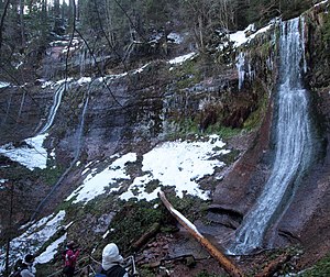
Sankenbach Waterfalls
Waterfall in Baden-Württemberg, Germany
Distance: Approx. 5318 meters
Latitude and longitude: 48.4853216,8.3332825
The Sankenbach Waterfalls (German: Sankenbach-Wasserfälle) are a cascade southwest of the village of Baiersbronn in the Black Forest in Germany. The Sankenbach flows over the waterfalls, dropping a total of 40 metres. The falls drop down the headwall of the cirque of the Sankenbach Bowl (Sankenbachkessel) in the Eckscher Horizon (Eck’scher Horizont) of the Lower Bunter Sandstone.

Rinkenkopf
Mountain in Germany
Distance: Approx. 5221 meters
Latitude and longitude: 48.515529,8.364081
The Rinkenkopf is a mountain, 760 m high, on the territory of Baiersbronn in the Northern Black Forest. The wooded mountain ridge is bounded in the south by the Murg valley and in the northeast by the valley of the Tonbach. To the northwest a roughly 50-metre-deep saddle (the Sattelei) separates it from the foothills of the Grindenschwarzwald.
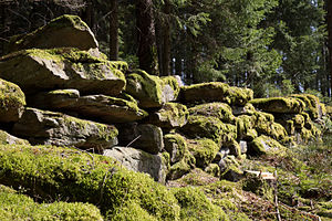
Rinkenwall
Distance: Approx. 5158 meters
Latitude and longitude: 48.515164,8.364781
The Rinkenwall or Rinkenmauer is a circular rampart fortification at the southeastern tip of the Rinkenkopf mountain above the Murg valley near the village of Baiersbronn in the county of Freudenstadt in the south German state of Baden-Württemberg. The hillfort could have been a fortification built to protect Reichenbach Abbey, which was built in the late 11th century and which is named as its owner.
Weather in this IP's area
overcast clouds
10 Celsius
9 Celsius
9 Celsius
10 Celsius
1023 hPa
98 %
1023 hPa
934 hPa
10000 meters
1.43 m/s
5.16 m/s
15 degree
100 %
07:04:59
19:37:31